Tropical Storm Arthur Slams Gulf Coast — First Named Storm of 2026 Brings Flooding Chaos
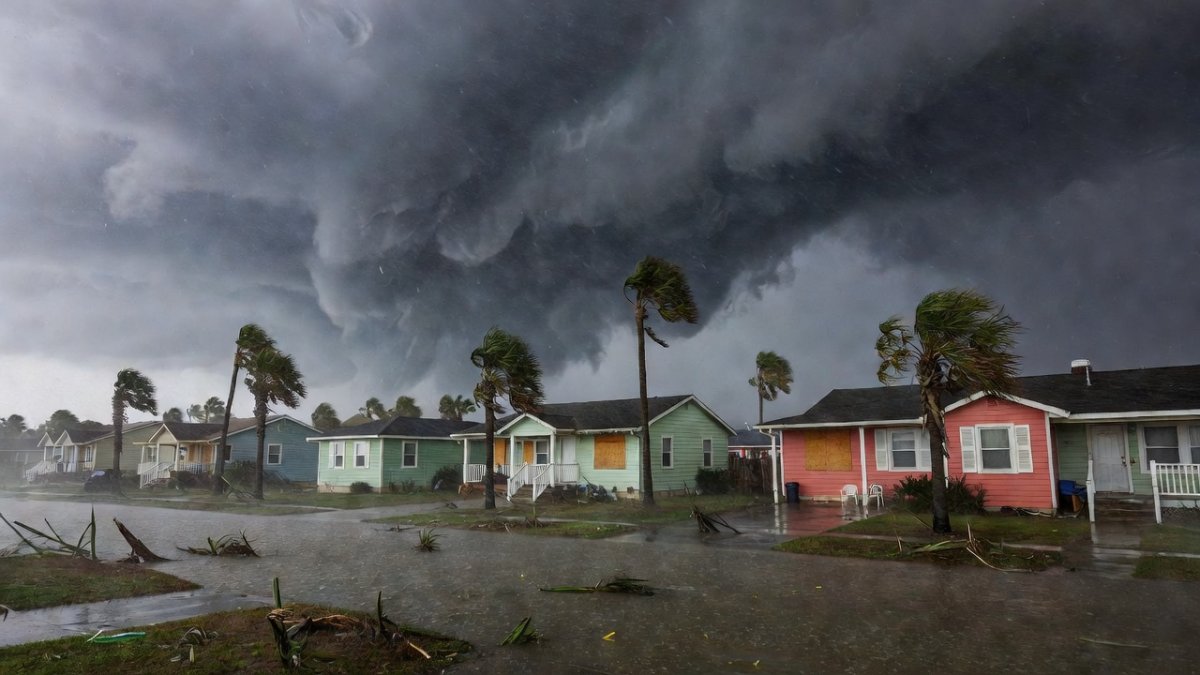
The Storm No One Saw Coming Until It Was Too Late Listen up, folks. Tropical Storm Arthur just crashed the party as the first named system of the 2026 Atlantic hurricane season, and it did it with zero fanfare and maximum mess. Forming on June 17 and slamming the Texas coast that same Wednesday afternoon, this poorly organized cyclone skipped the drama and went straight to floo
The Storm No One Saw Coming Until It Was Too Late
Listen up, folks. Tropical Storm Arthur just crashed the party as the first named system of the 2026 Atlantic hurricane season, and it did it with zero fanfare and maximum mess. Forming on June 17 and slamming the Texas coast that same Wednesday afternoon, this poorly organized cyclone skipped the drama and went straight to flooding neighborhoods from Houston to New Orleans. Heavy rain is still lashing Louisiana today, and the real threat isn't wind—it's water turning streets into rivers. NPR, CBS News, and AccuWeather are all tracking the same story: flash flooding across the Southern US that caught too many people off guard. Why should you care? Because this early arrival sets a tone for the season, and ignoring the warnings means your car could be the next one underwater. I'm fired up because the data shows we keep underestimating these quick-hit systems. Stay with me—this isn't hype, it's the truth about what just happened and what's still unfolding.
How a Tropical Wave and Cristina's Remnants Cooked Up Arthur
Let's break down the meteorology without the jargon. Arthur started as a tropical wave that merged with leftover moisture from Tropical Storm Cristina east of the Yucatán Peninsula. Warm Gulf waters supercharged the mix, spinning up a short-lived cyclone just off the Texas coast. The National Weather Service noted the system never got its act together—disorganized thunderstorms and weak circulation defined it from the start. AccuWeather's analysis highlighted how those remnant flows from Cristina provided the extra fuel, turning what might have been a nothing wave into a named storm in hours. Context matters here: early-season formation like this often signals above-average activity ahead, but Arthur's quick birth also shows how Gulf heat can manufacture threats overnight. Houston Chronicle reporting added that sea surface temperatures were running several degrees above normal, the exact recipe for rapid development. No spin, just facts—this mashup proves why monitoring every wave matters, even in June.
Wednesday Landfall: Winds, Timeline, and Instant Weakening
Wednesday afternoon delivered the punch. Arthur made landfall along the Texas coast with 40-plus mph wind gusts ripping through coastal communities. The timeline was brutal: formation just offshore in the morning, intensification by midday, and then the center crossing the shoreline by afternoon. Fox 26 Houston captured the gusts toppling signs and flooding low-lying roads within minutes of arrival. But here's the key detail—Arthur weakened to a post-tropical cyclone almost immediately after landfall because the land stripped away its energy source. ABC13 confirmed the rapid downgrade, with the system losing tropical characteristics by evening. Reuters and CBS News both emphasized how this fast cycle left little time for preparation. The 40-plus mph gusts were real but secondary; the storm's brevity meant the focus shifted instantly to rain. This wasn't a blockbuster hurricane, yet it still disrupted lives across two states in under 24 hours.
Flooding: The Danger That Won't Quit Across Texas and Louisiana
Flooding is the headline threat, and it's not letting up. The San Jacinto River Authority released water from Lake Conroe after heavy rain pushed levels to 201.24 feet above sea level, with an outflow of 529 cubic feet per second roaring downstream. That controlled release was necessary, but it added pressure on already saturated drainage systems. NPR reported ongoing concerns in the Houston metro area where streets became impassable. Louisiana is still catching the remnants today, with bands of heavy rain triggering flash flood warnings from the National Weather Service. Houston Chronicle detailed how poor drainage infrastructure in older neighborhoods turned routine downpours into dangerous events. AccuWeather's models showed totals exceeding six inches in spots, enough to overwhelm rivers and bayous. The post-tropical phase means Arthur's moisture keeps feeding storms farther east. This is the part that lingers—water doesn't care about official downgrades. Southern US residents know the drill, but each event exposes the same vulnerabilities in real time.
Rescue in Freeport: First Responders Doing the Hard Work
Two occupants were pulled from a vehicle stranded in floodwater in Freeport, a stark reminder that these storms turn everyday drives deadly. Local first responders acted fast, reaching the scene before conditions worsened. Fox 26 Houston aired footage of the rescue, showing crews using swift-water techniques to extract the people safely. ABC13 followed up with statements from authorities stressing that no one should have been on those roads in the first place. The incident highlights how quickly water rises—mere inches can sweep a car away. National Weather Service alerts had already flagged the area, yet the rescue shows the gap between warnings and action. Houston Chronicle quoted emergency officials noting multiple similar calls across the region. These teams train for exactly this, but the human cost adds up when drivers ignore "turn around, don't drown" messages. The Freeport save was one success story amid broader flooding, proving preparation at the local level still saves lives when systems fail.
What Arthur Signals for the Rest of Hurricane Season 2026
An early named storm like Arthur isn't automatic proof of a hyperactive season, but it demands attention. NOAA's seasonal outlook already pointed to warmer Atlantic waters and reduced wind shear, conditions that favor more activity. This first system forming from a wave-remnant combo shows how quickly threats can materialize before peak months. CBS News and Reuters both noted historical parallels where June storms preceded busier Julys and Augusts. Yet don't buy the hype—every season has variables, and Arthur's disorganized nature proves not every system becomes a monster. AccuWeather experts stressed monitoring the African wave train and Gulf temperatures as the real indicators. The precedent here is simple: readiness can't wait for July. Southern states saw what happens when drainage and timing collide. The 2026 season is underway, and Arthur's flooding footprint is the opening chapter, not the finale. Stay informed, not alarmed, but treat every update like it matters.
Action Steps: What You Need to Do Right Now
Check the National Weather Service alerts for your county today and set up push notifications—no excuses. Review your emergency kit: water, batteries, medications, and a go-bag ready for quick evacuation. Never drive through flooded roads; the Freeport rescue proves how fast that decision turns fatal. Help neighbors, especially elderly residents or those without transportation, by sharing ride options or checking on them directly. Houston-area officials recommend knowing your local drainage patterns and elevation risks before the next band moves in. Louisiana residents should monitor river levels and have sandbags staged if forecasts worsen. Talk to your family tonight about a meeting point and communication plan. These steps aren't panic—they're the difference between inconvenience and crisis. Local authorities from Texas to Louisiana are updating plans based on Arthur's data, so use that window. Action beats anxiety every time.
Stay Sharp and Keep Each Other Safe
Arthur showed up early, flooded hard, and left a reminder that preparation isn't optional. The rescues, lake releases, and ongoing Louisiana rain all trace back to one disorganized system that still packed a watery punch. Cut through the noise—focus on verified alerts from the National Weather Service and trusted local reporting. We've got the tools and the teams; now it's on all of us to use them. Check on your people, stay off the roads when water rises, and keep pushing for better infrastructure where it counts. This season is just getting started, and the truth is we control how ready we are. Let's move forward smarter and safer together. By Jessica Ali, Lead Anchor — Global 1 News
What's Your Reaction?
 Like
0
Like
0
 Dislike
0
Dislike
0
 Love
0
Love
0
 Funny
0
Funny
0
 Wow
0
Wow
0
 Sad
0
Sad
0
 Angry
0
Angry
0
Editor-in-Chief at Global1.News. Atlanta-based journalist who cuts through the BS and tells it like it is. Lead anchor, host, and the voice you hear when the spin stops and the truth starts.


Comments (0)