
Powerful 7.3 Quake Shakes Southern Mexico
A 7.3 earthquake struck off Chiapas on Friday, triggering tsunami warnings and evacuations across Mexico, Guatemala, and El Salvador. The quake caused limited damage in Tapachula with no fatalities, highlighting Mexico's seismic preparedness and regional cooperation.
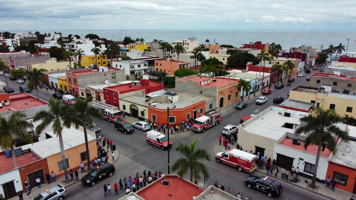
A powerful earthquake rippled through southern Mexico and into neighboring Central American nations on Friday, reminding communities along the Pacific coast of the ever-present geological forces shaping daily life from Chiapas to El Salvador. Residents in border towns felt the ground shift beneath their feet, prompting swift evacuations and highlighting the resilience built through years of regional cooperation. The event underscores how seismic activity binds the fates of Mexican states and Central American neighbors, where economic ties and migration routes cross the same vulnerable terrain.
Powerful 7.3 Quake Shakes Southern Mexico
Tapachula, Chiapas — Shaking intensified after an initial mild tremor, sending people into the streets as Protección Civil teams coordinated responses near the Guatemala border.
Tsunami Warning Triggers Coastal Precautions
The US Tsunami Warning Center recorded modest waves reaching 0.3 meters in Puerto Madero and along the Chiapas shoreline. Authorities issued alerts for both Mexican and Guatemalan coasts, though no major inundation followed. SEMAR vessels monitored sea conditions while local fishing communities stayed alert through the night.
Ground Response in Tapachula
In the moments after the powerful shaking subsided, residents of Tapachula poured into the streets, many still clutching whatever they had grabbed in haste. Dust hung in the air around the single collapsed structure, while neighbors helped one another check for injuries and assess cracked walls. Civil protection chief Demetrio Martínez quickly coordinated initial reports, noting that the damage remained limited yet demanded immediate attention across affected neighborhoods.
Evacuations unfolded in orderly fashion at schools, hospitals, and apartment blocks as teams moved through the city to verify structural safety. The injured Haitian migrant, who had jumped from a swaying building, received prompt care amid the confusion. Inspections continued through the afternoon, with officials prioritizing sites where families had gathered outside, waiting for clearance to return indoors.
Local voices carried a familiar mix of relief and resolve, reflecting years of living with the region's restless ground. Community members shared water and information while crews cordoned off the damaged site, underscoring how quickly daily rhythms in Tapachula can shift when the earth moves.
Subduction Zone Explains Persistent Seismic Risk
The July 17 magnitude 7.3 quake originated from the subduction of the Cocos Plate beneath the North American Plate at a shallow depth of 10-15 kilometers near the Mexico-Guatemala border. This tectonic boundary, which extends from Jalisco southward to Costa Rica, regularly produces large earthquakes because the plates converge at a steady rate, storing and releasing energy in sudden slips.
Chiapas and Oaxaca Face Heightened Seismic Activity
Chiapas and Oaxaca sit directly above the most active segment of this trench, making them especially prone to both strong shaking and secondary tsunami effects. The 0.3-meter waves recorded in Puerto Madero illustrate how even moderate offshore events can generate coastal hazards along this margin.
Comparable Subduction Zones Across Latin America
Comparable subduction zones elsewhere in Latin America, including the Peru-Chile trench and the Central American segment that affects El Salvador and Guatemala, share the same fundamental mechanics. Differences in convergence rate and sediment thickness influence the maximum magnitude and tsunami potential each zone can generate, yet all require sustained monitoring and preparedness.
Ongoing Tectonic Forces Shape Daily Realities
The Cocos Plate continues its steady descent beneath the North American Plate, generating the forces behind Friday's event. Chiapas and Oaxaca remain among Mexico's most active seismic zones, where fault lines run close to populated centers and vital trade corridors. This tectonic setting connects directly to the daily realities of farmers and merchants who live with the possibility of sudden disruption.
Historical Quakes Shape Modern Preparedness
The July 17 earthquake off the Chiapas coast fits into Mexico's long record of destructive events along the Pacific margin. The 1985 magnitude 8.0 quake in Mexico City claimed more than 10,000 lives, while the 2017 magnitude 7.1 Puebla event killed 370 people and the magnitude 8.2 Chiapas quake struck the same region only weeks earlier that year. These disasters prompted successive upgrades to national building codes, with stricter standards introduced after both 1985 and 2017 to improve resistance in high-risk zones.
The 1985 Mexico City earthquake left lasting lessons that reshaped how the country approaches construction and alerts. Its devastating toll prompted stricter building codes focused on flexibility and reinforcement, while also highlighting the need for earlier warnings along the coast. Those changes laid the groundwork for later expansions of the SASMEX sensor network, placing more instruments where subduction activity is most intense.
Decades later, the 2017 Puebla earthquake tested those updated standards in central regions and revealed remaining gaps in older structures. The disaster accelerated further code refinements and pushed for denser coverage of early-warning stations. Just weeks before, the powerful 2017 Chiapas event in the same subduction zone had already demonstrated the value of rapid alerts, prompting additional sensors to be installed along the Pacific margin to give coastal communities more seconds to react.
Each successive quake has reinforced the connection between memory and investment. Communities that lived through these events now treat drills and code compliance as routine parts of life, knowing that the upgrades trace directly back to hard-won experience rather than abstract planning.
Early Warning Systems and Regional Memory Drive Investment
Chiapas and Oaxaca remain among the country's most seismically active states because of their position above the Cocos Plate subduction zone. The SASMEX early-warning network, equipped with sensors along the entire Pacific coast, now provides seconds of advance notice to cities including Mexico City. In the recent event, this infrastructure helped limit damage despite the quake being felt from the capital to El Salvador.
Central American Impact Tests Cross-Border Cooperation
Although the epicenter lay just off the Mexico-Guatemala border, the July 17 shaking reached El Salvador and was reported across parts of Honduras, underscoring the transnational reach of subduction-zone events. CEPREDENAC, the Coordination Center for Disaster Prevention in Central America, facilitates information sharing and joint response protocols among member states, allowing rapid assessment of cross-border effects.
Trade Corridors and Migrant Vulnerability Highlight Regional Ties
Trade and migration corridors near Tapachula felt immediate disruption. One building sustained damage there, and two injuries occurred when a Haitian migrant jumped from a structure during the shaking. These incidents highlight the vulnerability of migrant communities living in temporary or substandard housing along the border region.
Lessons in Preparedness Across Uneven Terrain
Mexico's combination of the SASMEX early-warning system, upgraded building codes, and regular drills contrasts sharply with conditions in Haiti during its 2010 magnitude 7.0 earthquake, which caused more than 200,000 deaths. Similar disparities appear when comparing outcomes in El Salvador's 2001 magnitude 7.7 quake, which killed 944 people, and Guatemala's 1976 magnitude 7.5 event, which claimed 23,000 lives.
Regional Comparisons Highlight Progress and Gaps
The limited consequences of the July 17 Chiapas quake, with no fatalities and only minor reported damage, reflect decades of incremental investment in sensors, code enforcement, and public education. Coastal communities benefited from the brief warning window provided by Pacific sensors, allowing evacuations before the small tsunami waves arrived in Puerto Madero.
Across Latin America, Mexico's combination of the SASMEX network and evolving building codes stands in contrast to places where resources and coordination have historically lagged. The 2010 Haiti earthquake exposed how the absence of enforced standards and warning systems can turn a moderate event into catastrophic loss, while the 2001 El Salvador and 1976 Guatemala quakes similarly underscored the human cost when preparedness trails behind known seismic risk.
CEPREDENAC has worked to bridge these differences by fostering shared protocols and joint training among Central American nations. Its efforts emphasize that no single country can manage subduction-zone threats alone, especially when fault lines cross borders and migrant routes follow the same vulnerable corridors.
Regular community drills remain central to narrowing remaining gaps. They translate technical advances into everyday habits, helping residents recognize alerts and move quickly even in areas where infrastructure investment still trails behind that of wealthier neighbors.
By Elena Vasquez, Staff WriterThis article was produced with AI-assisted research and editorial support. Reporting is based on sources cited in the article.
What's Your Reaction?
 Like
0
Like
0
 Dislike
0
Dislike
0
 Love
0
Love
0
 Funny
0
Funny
0
 Wow
0
Wow
0
 Sad
0
Sad
0
 Angry
0
Angry
0

Latin America Correspondent at Global1.News. Based in Mexico City, covering politics, economics, energy, and culture across the region. Brings an on-the-ground perspective to stories spanning from the Rio Grande to Patagonia.












Comments (0)