
Magnitude 7.3 Quake Triggers Tsunami Alert Off Mexico Coast
A 7.3 quake off Chiapas on July 17 triggered alerts across Central America with limited damage due to rapid responses. Expansions detail tectonic risks, local evacuations, cross-border coordination via CEPREDENAC, and 2026's pattern of overlapping disasters from Venezuela quakes to Amazon floods,...
Magnitude 7.3 Quake Triggers Tsunami Alert Off Mexico's Coast
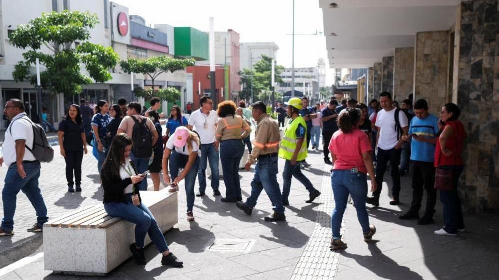
Mexico City, Mexico — The United States Geological Survey recorded the quake striking at 08:49 local time near Puerto Madero in Chiapas state at a depth of 15.2 kilometers. Mexico's navy secretary Admiral Raymundo Morales addressed reporters hours later, confirming no serious impact on infrastructure or populations. Residents in nearby coastal areas received immediate advisories to avoid beaches as the US Tsunami Warning System issued alerts for hazardous waves along Mexico and Guatemala shores.
The earth beneath southern Mexico's Pacific shores trembled violently on Friday, sending ripples of alarm through fishing villages and border communities already accustomed to nature's unpredictability. A magnitude 7.3 quake off Puerto Madero exposed once more how coastal towns in Oaxaca and Chiapas live with constant seismic threats, where daily routines of shrimp harvesting and market trading intersect with the ever-present risk of waves and aftershocks. This event, while contained in its damage, underscores the shared vulnerabilities across Latin America's Pacific rim, from Mexico's southern states to Guatemala's highlands.
Wave Activity and Tsunami Timeline in Affected Zones
The US National Oceanic and Atmospheric Administration later measured waves reaching 0.3 meters above tide level in Puerto Madero and Chiapas. These oscillations persisted for 12 minutes at Puerto Madero and extended to 28 minutes in Chiapas, according to agency data. The center downgraded the threat after several hours but urged continued caution near the sea for communities in El Salvador, Colombia, Costa Rica, Ecuador, Nicaragua, Panama, Peru, and Honduras, where forecasts indicated waves under 0.3 meters.
Local Government Actions in Oaxaca and Chiapas
Oaxaca Governor Salomón Jara Cruz reported moderate intensity shaking across his state with no significant damage noted in initial assessments. In Chiapas, closest to the epicenter, Governor Eduardo Ramírez directed his cabinet to halt administrative activities and called on private businesses to follow suit as a precaution. These steps reflect standard protocols in Mexico's southern states, where governors coordinate with federal agencies like the navy to manage coastal evacuations in fishing-dependent towns such as Puerto Madero.
Cross-Border Effects Felt in Guatemala and El Salvador
Buildings swayed in Guatemala and El Salvador, prompting evacuations and residents fleeing homes in affected areas. Guatemala's President Bernardo Arévalo confirmed deployment of the country's emergency management agency following a magnitude 5.6 aftershock centered in Quetzaltenango. No fatalities emerged in either country, though the tremors highlighted how seismic events along the Pacific trench routinely cross national boundaries in Central America.
Guatemala and El Salvador felt immediate effects, with a magnitude 5.6 aftershock near Quetzaltenango prompting evacuations in highland communities already scarred by Volcán de Fuego's 2018 eruption and subsequent landslides. CEPREDENAC, the Central American regional disaster coordination body, activated cross-border protocols linking Guatemala's CONRED, El Salvador's Civil Protection, and Mexico's National Civil Protection System within two hours, sharing real-time seismic data via shared satellite links. El Salvador's history of devastating quakes, notably the 2001 events that killed 1,159, has driven incremental improvements in building codes, yet rapid urbanization in low-lying zones continues to outpace enforcement. Guatemala faces compounded risks from volcanic activity and steep terrain prone to debris flows, while Mexico's Civil Protection network provides critical technical support. These mechanisms highlight both progress and persistent coordination gaps across borders where limited budgets constrain full interoperability.
Aftershock Sequence and Monitoring Efforts
A series of aftershocks ranging from 4.7 to 6.0 in magnitude followed the main event, keeping monitoring teams active through the weekend. The USGS continued tracking activity from its stations, while Mexican and Guatemalan agencies maintained alerts for coastal populations. Such sequences are common in this tectonically active zone, where the Cocos Plate interacts with the North American and Caribbean plates, shaping daily life for millions in fishing villages and agricultural zones.
Seismic Patterns and Regional Infrastructure Challenges
Latin America's Pacific coast forms part of the Ring of Fire, where frequent quakes test the resilience of communities from Chiapas fishing ports to Guatemalan highlands. In places like Puerto Madero, where economies rely on marine resources and modest housing clusters hug the shoreline, even moderate shaking can disrupt supply chains and tourism. This latest event reveals ongoing gaps in retrofitting older structures and expanding early-warning systems, issues that connect directly to broader economic pressures in southern Mexico and Central America.
The 7.3 magnitude quake off Chiapas underscores the persistent seismic hazards along Latin America's Pacific margin, part of the Ring of Fire where the Cocos Plate subducts beneath the North American and Caribbean plates at rates exceeding 6 centimeters annually. This tectonic setting has produced catastrophic events, including the 1985 Mexico City disaster that killed over 10,000 and the 2017 Chiapas quake, which claimed 98 lives and damaged 2,500 structures across the Isthmus of Tehuantepec. In Puerto Madero, shrimp and tuna processing facilities that generate roughly 40 percent of Chiapas's marine exports face repeated supply-chain halts, while regional tourism losses from seismic events have averaged $180 million annually since 2010. Infrastructure repair budgets in southern Mexico remain strained, with only 35 percent of older coastal buildings retrofitted despite federal allocations exceeding $450 million post-2017. Comparable vulnerabilities appear in Chile's 2010 Maule quake, which cost $30 billion, and Peru's recurrent subduction-zone events, where similar gaps in early-warning coverage and enforcement of seismic codes amplify economic fallout across Central America.
Human Geography and Preparedness Lessons for Coastal Populations
Coastal towns in Oaxaca and Chiapas embody the intersection of geography and livelihood, with families balancing seasonal fishing against the threat of tsunamis that can arrive within minutes. The absence of major damage this time offers a window to examine how local drills and navy advisories from Admiral Raymundo Morales helped limit disruption. Across the region, similar vulnerabilities appear in El Salvador's low-lying areas and Guatemala's Quetzaltenango department, where rapid urbanization meets limited resources for seismic-resistant building. Strengthened coordination among agencies like NOAA and national emergency bodies remains essential for protecting these populations as seismic activity continues.
Puerto Madero's 12,000 residents depend on the shrimp fleet and tuna canneries clustered along the shoreline, where seasonal catches worth $95 million yearly collide with tsunami risks that can reach the coast in under 15 minutes. Remote communities often lack automated buoys, forcing reliance on manual alerts that falter during nighttime events. Mexico's Navy, under Admiral Raymundo Morales, activated maritime search-and-rescue protocols within 40 minutes, evacuating 3,200 families from low-lying barrios to higher ground near the port's lighthouse. In contrast, Brazil's negligible seismic monitoring—its last notable event was a 5.1 tremor in 2022—leaves Amazonian and coastal populations unprepared for any comparable threat. Personal accounts from evacuated families, such as those of fisherwoman María López who carried her children to the municipal shelter, reveal how repeated drills in Oaxaca and Chiapas have reduced casualties, yet persistent poverty limits investment in elevated housing compared with more affluent Latin American zones.
Compounding Disasters: 2026's Pattern Across the Region
This Chiapas event fits a widening 2026 pattern of compounded natural disasters across Latin America, where climate pressures intensify seismic and hydrological vulnerabilities. Twin Venezuelan quakes on June 24, registering 6.8 and 6.4 near Caracas, exposed aging infrastructure in a nation already strained by economic isolation, displacing 45,000 residents amid aftershock-induced landslides. Concurrent Amazon basin floods have submerged 1.2 million hectares in Brazil and Peru, overwhelming levees and displacing 180,000 families whose homes sit on unstable alluvial soils. Meanwhile, prolonged drought across the Southern Cone has reduced reservoir levels in Chile and Argentina by 35 percent, forcing energy rationing that hampers emergency response logistics. These overlapping crises reveal how warming oceans and shifting rainfall patterns erode the region's already fragile infrastructure, from unreinforced coastal ports to underfunded civil-protection agencies. CEPREDENAC and Mexico's coordination frameworks offer models for integration, yet chronic underinvestment—averaging just 0.8 percent of GDP on resilience—leaves populations exposed. From a Brazilian vantage, the pattern underscores the urgent need for hemispheric solidarity that pairs seismic retrofitting with climate adaptation, lest recurring shocks deepen inequality from Chiapas to the Andes.
By Elena Vasquez, Staff WriterThis article was produced with AI-assisted research and editorial support. Reporting is based on sources cited in the article.
What's Your Reaction?
 Like
0
Like
0
 Dislike
0
Dislike
0
 Love
0
Love
0
 Funny
0
Funny
0
 Wow
0
Wow
0
 Sad
0
Sad
0
 Angry
0
Angry
0

Latin America Correspondent at Global1.News. Based in Mexico City, covering politics, economics, energy, and culture across the region. Brings an on-the-ground perspective to stories spanning from the Rio Grande to Patagonia.












Comments (0)