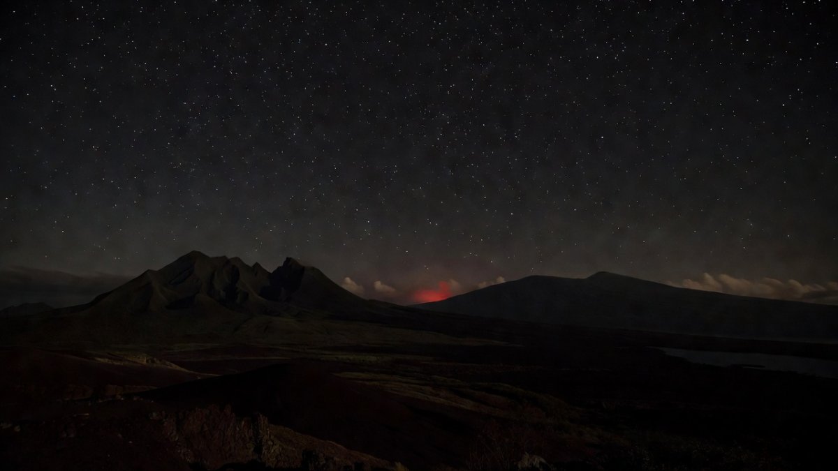
Breaking: 4.7 Quake Rocks Hawaii's Big Island in the Dead of Night
Big Island Shaken Awake: M4.7 Quake Strikes at 2:37 AM HST, Nearly 800 Reports Pour In Folks, let me tell you exactly what happened. A solid M4.7 earthquake hit the Big Island right in the middle of the night, jolting people out of bed across Hilo and the surrounding areas. This wasn't some tiny rumble that folks might shrug off. Nearly 800 people felt it and logged their exper
Big Island Shaken Awake: M4.7 Quake Strikes at 2:37 AM HST, Nearly 800 Reports Pour In
Folks, let me tell you exactly what happened. A solid M4.7 earthquake hit the Big Island right in the middle of the night, jolting people out of bed across Hilo and the surrounding areas. This wasn't some tiny rumble that folks might shrug off. Nearly 800 people felt it and logged their experiences, which tells you this one packed enough punch to grab attention even in a place used to shaking ground. The Big Island is no stranger to quakes, but this nighttime strike at 2:37 AM HST made sure plenty of residents were wide awake and checking their phones for answers.
Breaking Down the Numbers — What the USGS Confirmed
Here's the deal on the hard numbers. The quake registered M4.71 magnitude on the ml scale, with a preliminary M4.4 mb reading that seismologists later refined. It struck at a depth of 39.18 km, or about 24.4 miles, which is deep enough to spread the energy but not so shallow that it caused major surface damage. The exact time was June 10, 2026, at 08:37:40 UTC, translating to 2:37 AM HST locally. Fifty-four seismic stations fed data into the system, and the event carries full reviewed status after seismologists double-checked every reading. That review process means this is confirmed, not some preliminary guess that might change later.
Let me break it down further so you see why these details matter. The magnitude sits right in the range where people notice the ground moving but major destruction stays unlikely. Depth plays a huge role here because 39 km gives the waves time to lose some strength before reaching the surface. Those 54 stations provided a dense network of readings that locked in the location and size with high confidence. Reviewed status confirms the Hawaiian Volcano Observatory and USGS teams have signed off, so the data you are hearing now is solid.
Where the Epicenter Hit — Mapping the Shake Zone
The epicenter landed 23 km east of Pāpa'ikou on the Big Island, with Paukaa sitting just 11 km to the west. That placed the shake zone right in the path of several key communities. Hilo felt the motion clearly, as did Kea'au, Mountain View, and the entire Hamakua Coast. These population centers sit close enough that the energy traveled efficiently, which explains why so many residents reported feeling the quake even though the magnitude stayed moderate.
Think about the geography for a second. Pāpa'ikou and Paukaa sit on the windward side where the terrain funnels shaking toward Hilo. From there the waves reached Kea'au and Mountain View without losing too much strength. The Hamakua Coast communities also picked up the motion because the fault movement aligned in a way that sent energy their direction. No one area took the full brunt, but the spread across these towns shows how one moderate quake can touch multiple spots at once.
Nearly 800 Felt Reports — What That Tells Us
CDI came in at 4.3 while MMI registered 4.252, which lines up with light to moderate shaking. That level means hanging objects swing, dishes rattle, and some people get startled enough to wonder if they should head outside. The 789 felt reports through the USGS "Did You Feel It?" system give scientists a real-time map of exactly where the energy reached and how strong it felt on the ground. Each report adds a data point that refines the intensity picture beyond what instruments alone can show.
Felt data works like this: regular people become part of the measurement network. When hundreds log their experience, patterns emerge that show which neighborhoods shook harder and which ones only got a gentle roll. MMI 4 means most people indoors notice the movement while a few outdoors might miss it. CDI 4.3 adds the community decimal scale that captures how the average person described the event. Together these numbers confirm the quake was noticeable but stayed well below the threshold for serious alarm.
GREEN Alert and No Tsunami — What PAGER Actually Means
The PAGER system issued a GREEN alert, which signals low potential for casualties and economic losses. GREEN means the combination of magnitude, depth, and location points to limited impact, so no major emergency response gets triggered. Economic exposure stays minimal because the energy did not concentrate on dense urban infrastructure. Casualty estimates remain very low for the same reason. No tsunami warning followed because the quake lacked the characteristics that generate dangerous waves, and the alert stayed GREEN across the board.
Why does this matter in real time? PAGER gives responders a quick snapshot so they do not overreact to every shake. GREEN tells emergency managers they can monitor rather than mobilize heavy resources. The absence of a tsunami threat kept coastal communities from unnecessary evacuations. Still, the alert system worked exactly as designed by flagging the event, confirming the low risk, and letting everyone return to normal without added panic.
Hawaii's Volcanic Setting — Why This Was Expected Geology
Hawaii sits in earthquake country because the islands grow on top of a hot spot that keeps the crust active. Kīlauea and Mauna Loa generate hundreds of quakes every year, most of them in the M2 to M3 range that barely register with residents. An M4.7 stands out as notable but not unusual in that setting. The 2018 M6.9 event and the 2006 M6.7 quake showed what larger magnitudes can do, while the ongoing Pāhala swarm reminds everyone that smaller events happen constantly beneath the surface.
Volcanic quakes differ from tectonic ones because they often tie directly to magma movement or pressure changes inside the volcanoes. This M4.7 fits the pattern of background activity that keeps the Hawaiian Volcano Observatory busy year-round. Residents know the ground moves here, yet each felt event still serves as a reminder that the islands sit on dynamic geology that never truly sleeps.
How HVO Tracks the Shaking — 54 Stations in Action
The Hawaiian Volcano Observatory runs a network of 54 seismic stations that feed real-time data straight into monitoring centers. Those stations picked up every wave from this event and allowed scientists to separate tectonic signals from any volcanic ones. Real-time processing means the location, depth, and magnitude get calculated within minutes, giving the public accurate information fast. HVO's dual role watching both earthquakes and volcanoes lets them spot whether a quake links to Kīlauea activity or stands alone as a tectonic release.
Differentiating quake types matters because volcanic events can sometimes precede changes in eruptive behavior. The 54-station array provides enough coverage to make that call with certainty. When the data showed no alert change at Kīlauea, it confirmed this quake stayed in the normal range of island seismicity rather than signaling something new at the volcano.
What to Do When the Ground Moves — Safety Reminder
Nighttime quakes always feel scarier because you wake up disoriented with the room moving. The rule stays the same though: drop, cover, and hold on until the shaking stops. Secure heavy items like bookshelves and water heaters ahead of time so they do not become hazards when the ground lurches. Hawaii communities have lived through plenty of these events, yet quick reminders still save lives by keeping the right actions fresh in everyone's mind.
Drop to the floor, get under a sturdy table, and hold on tight. Stay inside unless you are near a coast where tsunami risk exists, which was not the case here. After the shaking ends, check for gas leaks or structural damage before moving around too much. These steps work whether the quake hits at 2 AM or 2 PM, and repeating them keeps everyone sharper when the next one arrives.
What Happens Next — Aftershocks and Monitoring
HVO continues watching for aftershocks that could follow the main event. Aftershocks are normal and usually smaller, but they keep the network on alert for any changes. USGS teams will keep updating intensity maps as more felt reports come in. If you experienced the quake, logging your details on the "Did You Feel It?" page helps refine those maps and improves future hazard assessments. Checking the USGS website or HVO updates gives the latest official information without the noise of unverified social media posts.
Monitoring stays active because even a moderate quake can shift stress on nearby faults. The reviewed status means scientists have a clean baseline to compare against any follow-up activity. Residents on the Big Island know the drill: stay informed, report what you felt, and keep an eye on official channels for any updates that might come in the hours and days ahead.
Bottom Line — Stay Sharp, Hawaii
This was a wake-up call, literally. The data is solid, the system worked, and now we stay vigilant. An M4.7 in the middle of the night proves the monitoring network catches events quickly and delivers clear information. GREEN alert status and zero tsunami threat kept the response proportionate. Hawaii's volcanic setting means more shaking will come, yet each event like this one shows the preparedness in place.
If you felt this quake, log it on the USGS "Did You Feel It?" page — your experience helps build the map. Share this article with someone on the Big Island. Stay safe out there.
By Jessica Ali, Global 1 News
What's Your Reaction?
 Like
0
Like
0
 Dislike
0
Dislike
0
 Love
0
Love
0
 Funny
0
Funny
0
 Wow
0
Wow
0
 Sad
0
Sad
0
 Angry
0
Angry
0
Editor-in-Chief at Global1.News. Atlanta-based journalist who cuts through the BS and tells it like it is. Lead anchor, host, and the voice you hear when the spin stops and the truth starts.


Comments (0)