Peru Amazon Deforestation Crisis Escalates in 2025
In the heart of the Peruvian Amazon, Indigenous communities like the Kakataibo and Wampis are watching their ancestral forests vanish at an alarming rate. Satellite data from MAAP and Global Forest Watch reveals that Peru lost 124,000 hectares of Amazon rainforest in 2025 alone — a crisis driven by agriculture, illegal gold mining, and the advancing coca frontier. With El Nino
In the heart of the Peruvian Amazon, Indigenous communities like the Kakataibo and Wampis are watching their ancestral forests vanish at an alarming rate. Satellite data from MAAP and Global Forest Watch reveals that Peru lost 124,000 hectares of Amazon rainforest in 2025 alone — a crisis driven by agriculture, illegal gold mining, and the advancing coca frontier. With El Nino conditions expected in 2026, the destruction risks accelerating further, threatening the region's biodiversity and the livelihoods of those who call it home.
Peru's Amazon Under Siege: 124,000 Hectares Lost as Agriculture and Illegal Mining Devour the Rainforest
Lima, Peru — June 29, 2026 — The Peruvian Amazon is losing ground to a multi-front assault that stripped 124,000 hectares of forest in 2025, satellite data confirms. Agriculture accounts for 94.6 percent of the loss, while illegal gold mining — concentrated in the Madre de Dios region — has produced a cumulative 139,169 hectares of scarred landscape, contaminating 225 rivers across nine regions.
Human Angle: Communities on the Frontlines
Indigenous communities such as the Kakataibo and Wampis stand at the center of Peru's Amazon crisis. These groups have long protected vast forest territories yet now confront direct violence from encroaching loggers and miners. Indigenous Guards patrol remote borders daily, documenting incursions while facing threats that have escalated in recent years. The human cost extends beyond statistics as families lose access to clean rivers and traditional hunting grounds. Reports from organizations including Amazon Watch and SPDA highlight repeated attacks on community leaders who oppose illegal activities. In Madre de Dios alone, cumulative illegal gold mining has already claimed 139,169 hectares, with 97.5 percent concentrated in this single region. This loss disrupts entire ways of life for people who depend on the forest for food, medicine, and cultural continuity. El Nino conditions expected in 2026 threaten to intensify these pressures by drying forests and making them more vulnerable to fire and clearing. Community members describe watching rivers turn muddy from upstream mining while mercury levels rise in fish they once ate safely. The 132,000 hectares lost inside protected areas and Indigenous territories represent not only ecological damage but also the erosion of ancestral rights. Despite these challenges, groups continue to deploy basic monitoring tools and seek alliances with institutions like IIAP and GIZ to strengthen their defenses. Their resilience underscores the urgent need for sustained support against expanding threats from multiple sectors.
Deforestation Numbers Reveal Scale of Loss
The Amazon basin lost 736,484 hectares of forest in 2025 according to MAAP, UMD GLAD, and Global Forest Watch data. Peru accounted for approximately 16.8 percent of this total, equaling roughly 124,000 hectares within its borders. These figures place Peru among the most affected countries in the basin. Of the Peruvian loss, 94.6 percent stemmed from agriculture while 5.3 percent resulted from illegal gold mining. An additional 132,000 hectares disappeared inside protected areas and Indigenous territories, showing that legal safeguards have not halted the advance. Mining operations have now spread across nine regions and affected 225 rivers and streams. In Madre de Dios, more than 3,000 hectares were cleared between May and October 2025 alone. Such rapid clearing in a single season illustrates how quickly forests can vanish when enforcement lags. The concentration of mining damage in Madre de Dios, representing 97.5 percent of cumulative illegal gold mining losses totaling 139,169 hectares, reveals a geographic hotspot that demands targeted intervention. Data from MINAM and SERFOR confirm that these losses compound annually, reducing carbon storage capacity and fragmenting habitats. Without stronger measures, projections tied to El Nino suggest even higher rates in 2026 as drier conditions facilitate easier access for clearing crews. The numbers provide a clear baseline for measuring future progress or continued decline across the Peruvian Amazon.
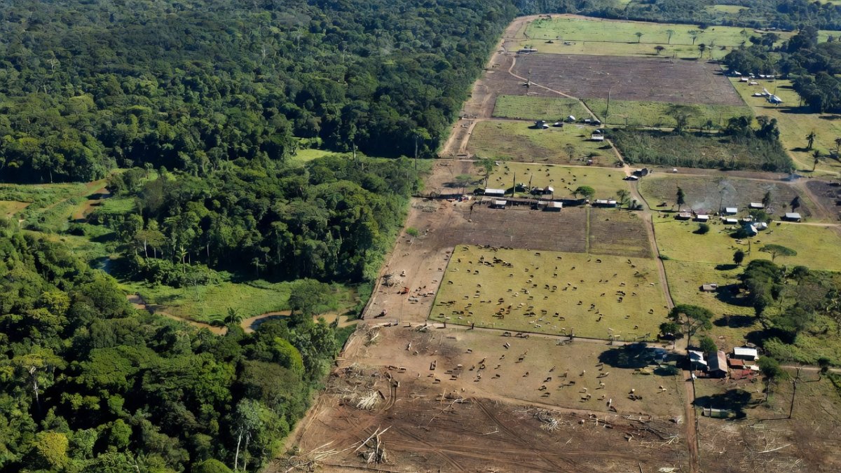
Agriculture Remains Primary Driver
Agriculture drove 94.6 percent of Peru's 124,000 hectares of Amazon deforestation in 2025. Small-scale and commercial operations alike convert forest into pasture and cropland at accelerating rates. This dominance of agricultural expansion overshadows other causes and reflects growing demand for commodities both domestically and internationally. Areas once covered by dense canopy now support cattle or monoculture plots, releasing stored carbon and reducing biodiversity. The 736,484 hectares lost across the broader Amazon basin include Peru's substantial share, underscoring how national trends mirror regional patterns. Institutions such as SERFOR track these conversions yet struggle to keep pace with the speed of clearing. In regions like Ucayali and Loreto, agricultural frontiers advance steadily into previously intact zones. The overlap with protected areas and Indigenous territories, where 132,000 hectares were lost, shows that even designated lands are not immune. El Nino forecasts for 2026 raise concerns that drier weather will further ease agricultural expansion by lowering natural barriers. Data from MAAP and Global Forest Watch provide precise mapping that helps identify priority zones for intervention. Without addressing the economic incentives behind agricultural clearing, Peru risks continued high annual losses that undermine national climate commitments and local ecosystem services.
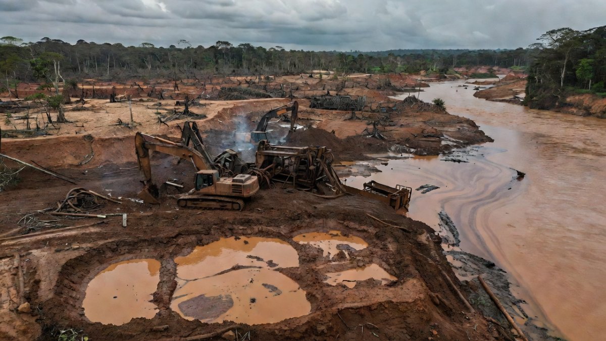
Illegal Gold Mining Crisis Intensifies
Illegal gold mining accounted for 5.3 percent of Peru's 2025 deforestation yet produced outsized cumulative damage totaling 139,169 hectares. Madre de Dios holds 97.5 percent of this scarred landscape, with operations now extending into eight additional regions. The activity has polluted 225 rivers and streams, altering water flows and sediment loads across wide areas. Between May and October 2025, Madre de Dios alone lost over 3,000 hectares to mining. These operations often occur inside or adjacent to protected areas and Indigenous territories, contributing to the 132,000 hectares of documented losses in such zones. The spread demonstrates how mining adapts to enforcement gaps by shifting locations rapidly. MINAM and OSINFOR monitor these sites, but the remote terrain complicates consistent oversight. Mining also intersects with other pressures, creating compound threats that accelerate overall forest loss. The 736,484 hectares basin-wide total includes Peru's mining-related share, highlighting the activity's role in regional degradation. As El Nino approaches in 2026, reduced river levels may expose new mining sites and intensify existing ones. Coordinated responses involving SERFOR and international partners remain essential to curb this expanding crisis before further rivers and forests are compromised.
Indigenous Communities Face Mounting Pressures
Indigenous territories absorbed significant portions of the 132,000 hectares lost inside protected areas and Indigenous lands in 2025. The Kakataibo and Wampis, among others, endure direct confrontations with miners and loggers who enter their territories illegally. Indigenous Guards operate with limited resources to deter these incursions, often at personal risk. Violence against community monitors has increased as economic interests push deeper into remote zones. The 139,169 hectares of cumulative illegal gold mining damage, concentrated 97.5 percent in Madre de Dios, directly overlaps with ancestral lands in multiple cases. Agricultural clearing, responsible for 94.6 percent of Peru's 124,000 hectares lost, further fragments these territories. Nine regions now host mining activity that affects 225 rivers and streams vital to Indigenous livelihoods. El Nino conditions projected for 2026 could worsen access for outsiders by drying paths through the forest. Organizations including Amazon Watch, SPDA, and IIAP work alongside communities to document violations and advocate for stronger protections. The human dimension of these losses includes disrupted cultural practices and heightened health risks from contaminated resources. Sustained support for Indigenous monitoring remains critical to reversing trends that threaten both people and the 736,484 hectares lost across the Amazon basin.
Mercury Contamination Poses Health Risks
Mercury released during illegal gold mining contaminates waterways across the Peruvian Amazon. Operations responsible for 139,169 cumulative hectares of damage, mostly in Madre de Dios, introduce this toxin into 225 affected rivers and streams. Fish consumed by local populations accumulate mercury, creating long-term health concerns for communities already stressed by the 124,000 hectares of 2025 deforestation. The 5.3 percent of losses attributed to mining in Peru contributes to this persistent pollution problem. Indigenous groups including the Kakataibo and Wampis report changes in water quality that affect daily life and traditional diets. Data from MAAP and IIAP track the geographic spread of mining into nine regions, correlating with rising contamination zones. Protected areas and Indigenous territories, which lost 132,000 hectares, suffer similar exposure when mining occurs nearby. El Nino in 2026 may concentrate mercury in remaining water bodies as flows diminish. MINAM and GIZ support studies that quantify these impacts, yet remediation lags behind the pace of new mining. The health burden compounds other pressures from agriculture and coca cultivation, creating overlapping vulnerabilities for forest-dependent populations. Addressing mercury requires both halting new mining and managing legacy contamination from existing sites.
Coca Cultivation Advances onto Indigenous Lands
Coca cultivation continue
 s to advance onto Indigenous territories, adding another layer to the 124,000 hectares of Peruvian Amazon deforestation recorded in 2025. This expansion often occurs alongside agricultural clearing that accounts for 94.6 percent of losses. Narco-related activities exploit remote areas where enforcement is weak, converting forest into illicit crops. The 132,000 hectares lost inside protected areas and Indigenous territories include zones impacted by coca frontiers. Communities such as the Wampis and Kakataibo face additional security risks when these operations overlap with their lands. Mining, which has cumulatively damaged 139,169 hectares with 97.5 percent in Madre de Dios, sometimes coexists with coca plots, creating complex conflict zones. Nine regions now experience mining effects on 225 rivers and streams, and coca follows similar patterns of infiltration. El Nino forecasts suggest drier conditions could facilitate further planting in 2026. Institutions including SERFOR and OSINFOR monitor these trends, while SPDA and Amazon Watch document community impacts. The intersection of coca with other drivers accelerates overall forest loss beyond the basin-wide 736,484 hectares recorded. Targeted strategies that combine eradication with alternative livelihoods are needed to protect remaining Indigenous territories from this advancing threat.
Government Response Mobilizes Institutions
Peruvian government agencies including MINAM and SERFOR coordinate responses to the 124,000 hectares of deforestation recorded in 2025. Control posts established in Ucayali, Junin, Loreto, and Madre de Dios aim to intercept illegal timber and mining equipment. These efforts address the 5.3 percent mining share and the dominant 94.6 percent agricultural driver. OSINFOR oversees forest concessions while IIAP provides scientific backing for policy. The 139,169 hectares of cumulative illegal gold mining damage, concentrated in Madre de Dios, receives focused attention through interagency task forces. Despite these measures, losses inside protected areas and Indigenous territories reached 132,000 hectares, indicating gaps in coverage. Mining has spread to nine regions affecting 225 rivers and streams, requiring expanded patrols. El Nino projections for 2026 prompt preparatory planning to prevent accelerated clearing. Partnerships with GIZ and SPDA strengthen capacity for monitoring and community engagement. The broader Amazon basin loss of 736,484 hectares places Peru's response within a regional context that demands cross-border cooperation. Continued investment in these institutions remains essential to translate data into effective on-the-ground reductions.
Technology and Enforcement Tools Expand
Technology supports enforcement against the 124,000 hectares of 2025 deforestation in Peru. Drones and AI systems deployed by MAAP and SERFOR enable near-real-time detection of clearing in remote zones. MaderApp assists in tracking legal timber flows to reduce illegal logging linked to agricultural expansion. Control posts in Ucayali, Junin, Loreto, and Madre de Dios integrate these tools to monitor traffic along key routes. The 139,169 hectares of cumulative mining damage, 97.5 percent in Madre de Dios, is mapped more precisely through satellite analysis from UMD GLAD and Global Forest Watch. Indigenous Guards receive training to use basic tech for documenting incursions into territories that lost portions of the 132,000 hectares inside protected areas. Mining impacts on 225 rivers and streams across nine regions are tracked to prioritize interventions. El Nino risks in 2026 underscore the value of predictive modeling to anticipate new clearing hotspots. Collaborations involving IIAP and GIZ enhance data sharing among agencies. These technological advances complement traditional patrols and help address the basin-wide 736,484 hectares lost in 2025 by improving response times and targeting resources effectively.
Amazonia 2030 Framework Offers Path Forward
The Amazonia 2030 framework promotes bioeconomy approaches to counter the 124,000 hectares of Peruvian deforestation recorded in 2025. This strategy emphasizes sustainable value chains that generate income without clearing forest. Drones, AI, and MaderApp form part of the technological backbone supporting monitoring and legal supply chains. Institutions such as MINAM, SERFOR, and IIAP collaborate on implementation while GIZ provides technical assistance. The framework addresses both the 94.6 percent agricultural driver and the 5.3 percent mining contribution to losses. Indigenous territories, which saw portions of the 132,000 hectares lost inside protected areas, stand to benefit from bioeconomy models that respect community rights. Control posts in Ucayali, Junin, Loreto, and Madre de Dios integrate into broader enforcement under this vision. El Nino conditions anticipated for 2026 highlight the need for resilient economic alternatives that reduce pressure on forests. SPDA and Amazon Watch contribute civil society perspectives to ensure inclusive design. By linking data from MAAP and Global Forest Watch with on-the-ground action, Amazonia 2030 seeks to reverse trends that contributed to the 736,484 hectares basin-wide loss while building long-term economic alternatives for forest communities.
The Bottom Line
Peru's Amazon faces compounded threats from agriculture, mining, coca, and climate factors that produced 124,000 hectares of loss in 2025. The 736,484 hectares basin total, Peru's 16.8 percent share, and the 132,000 hectares inside protected areas and Indigenous territories demonstrate the urgency. Mercury from 139,169 cumulative mining hectares, concentrated in Madre de Dios, adds health dimensions while 225 rivers suffer impacts across nine regions. Indigenous communities endure violence as they defend their lands. El Nino in 2026 risks worsening outcomes. Government institutions, technology, and the Amazonia 2030 framework provide tools for response, yet sustained commitment is required to protect remaining forests and the people who depend on them. Data from MAAP, SERFOR, and partners must translate into measurable reductions in future years.
What's Your Reaction?
 Like
0
Like
0
 Dislike
0
Dislike
0
 Love
0
Love
0
 Funny
0
Funny
0
 Wow
0
Wow
0
 Sad
0
Sad
0
 Angry
0
Angry
0
Latin America Correspondent at Global1.News. Based in Mexico City, covering politics, economics, energy, and culture across the region. Brings an on-the-ground perspective to stories spanning from the Rio Grande to Patagonia.


Comments (0)