Navigating the 2026 Atlantic Hurricane Season: Arthur Arrives, El Nino Looms, and the Caribbean Prepares
Navigating the 2026 Atlantic Hurricane Season: Arthur Arrives, El Niño Looms, and the Caribbean Prepares pThe 2026 Atlantic hurricane season is upon us, and after the early arrival of Tropical Stor
The 2026 Atlantic hurricane season is upon us, and after the early arrival of Tropical Storm Arthur and NOAA's below-normal forecast, Caribbean communities are watching the skies with cautious attention. From Trinidad and Tobago to Jamaica, families are taking stock of what this season means for daily life across our islands.
Navigating the 2026 Atlantic Hurricane Season: Arthur Arrives, El Niño Looms, and the Caribbean Prepares
Port of Spain, Trinidad and Tobago – June 2026 — As the Atlantic basin settles into its annual hurricane rhythm, residents across the Caribbean are balancing a below-normal outlook with the real-world reminder that even quiet seasons can produce systems that test community preparedness. The One Caribbean Forecast video from One Caribbean Television has been helping families interpret the signals and plan accordingly.
The One Caribbean Forecast and What It Means for Daily Caribbean Life
The One Caribbean Forecast serves as a vital community resource that brings together meteorologists and regional experts to discuss the season ahead in language that resonates with ordinary families across the islands. In Trinidad and Tobago, where many households tune in together on evenings after work, the forecast translates complex weather patterns into practical advice about when to secure zinc roofs, stock extra water, or check on elderly neighbours. This approach fosters a sense of shared responsibility rather than fear, reminding viewers that preparation is part of our cultural fabric. Daily life in places like Port of Spain or San Fernando often revolves around outdoor markets and fishing, so understanding early signals helps vendors protect their goods and fishermen plan safer outings. The forecast also highlights how Saharan dust can reduce visibility and affect breathing, encouraging parents to keep children indoors during heavy haze. By grounding predictions in local realities, it strengthens community bonds and encourages neighbours to share resources such as generators or canned goods well before any system approaches.
NOAA's Below-Normal Outlook Explained in Detail with the Specific Numbers
The National Oceanic and Atmospheric Administration released its 2026 Atlantic Hurricane Season Outlook in May, projecting a below-normal season with 55 percent confidence. Forecasters anticipate between 8 and 14 named storms, of which 3 to 6 are expected to reach hurricane strength and 1 to 3 to become major hurricanes. These figures sit below the long-term average and reflect the anticipated development of El Niño conditions that typically suppress Atlantic activity through increased wind shear. For Caribbean nations, this outlook offers cautious reassurance but does not eliminate risk, as even a single storm can bring significant rainfall and flooding. Officials in Trinidad and Tobago have noted that the numbers guide planning for the June to November period without creating complacency. The outlook also reminds communities that activity often clusters between August and October, the traditional peak. While the reduced numbers are welcome, regional meteorologists stress that every household should still review insurance policies and evacuation routes, because historical seasons with similar forecasts have still produced impactful systems that affect agriculture and coastal infrastructure.

Tropical Storm Arthur: Formation, Path, Rainfall, and What It Signals
Tropical Storm Arthur formed on 17 June 2026 in the Gulf of Mexico, arriving just days ahead of the average first-named-storm date of 20 June. The system tracked toward the United States Gulf Coast, delivering between 5 and 10 inches of rain in most areas with isolated totals reaching 20 inches. Although Arthur remained distant from the eastern Caribbean, its early development served as a timely reminder that the season begins on 1 June and runs through 30 November. In Trinidad and Tobago, news of Arthur prompted families to review their hurricane kits and check drainage around homes, even though direct impacts were minimal. The storm's rainfall patterns demonstrated how moisture from the Gulf can influence weather far beyond its centre, sometimes feeding showers across the southern Caribbean. Community groups in Tobago used the event to organise small workshops on clearing blocked drains, reinforcing the idea that early-season activity offers practice for later months. Arthur also highlighted the importance of monitoring updates from the National Hurricane Center, as even below-normal seasons can produce systems that test preparedness at the community level.
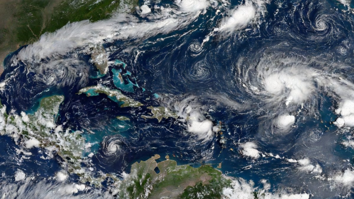
Current NHC Tracking: Details on the Four Tropical Waves and Saharan Dust
The National Hurricane Center is currently monitoring four tropical waves across the Atlantic basin. One wave sits in the far eastern Atlantic near 21W, another in the central Atlantic around 60W south of 19N, a third near the Anegada Passage in the Caribbean at 66W south of 19N, and the fourth in the eastern Atlantic at 27W. None of these waves show immediate signs of organisation, and the seven-day outlook issued on 20 June indicates no tropical cyclone formation is expected across the North Atlantic, Caribbean Sea or Gulf of Mexico in the near term. At the same time, Saharan dust continues to affect parts of the Caribbean, reducing air quality and sometimes suppressing shower activity. In Trinidad and Tobago, residents notice the hazy skies and take extra care with respiratory health, particularly in rural communities where access to medical facilities can be limited. These waves and the dust layer together illustrate the varied influences that shape our weather during the season, reminding families to stay informed through official channels rather than relying on rumours that sometimes circulate in markets and on social media.
El Niño's Mechanics and Caribbean Implications
El Niño develops when warmer-than-average waters in the central and eastern Pacific alter global wind patterns, often increasing upper-level winds over the Atlantic that tear apart potential storms. This mechanism tends to reduce the number of hurricanes that form and reach the Caribbean, which aligns with the current below-normal outlook. For islands such as Trinidad and Tobago, the effect can mean fewer direct hits but does not remove the possibility of heavy rainfall events or flooding from passing systems. Farmers in the central plains watch these forecasts closely because even suppressed seasons can bring prolonged wet periods that damage crops like cocoa and vegetables. Coastal communities also consider how changes in sea-surface temperatures influence fish stocks, affecting livelihoods that depend on the sea. While El Niño offers a measure of relief, experts caution that the phenomenon can shift rainfall patterns in ways that still challenge water management and agriculture. Families are encouraged to maintain flexible plans that account for both reduced storm counts and the lingering possibility of disruptive weather throughout the season.
Hurricane Preparedness Specifically for Trinidad and Tobago Homes and Communities
In Trinidad and Tobago, preparedness begins at the household level with simple but consistent actions. Families are advised to secure loose roofing sheets, trim overhanging branches, and identify the nearest community centre designated as a shelter. The Office of Disaster Preparedness works with local groups to distribute checklists that include battery-powered radios, stored drinking water, and copies of important documents. In rural areas such as Mayaro or Cedros, neighbours often form small networks to assist elderly residents who may need help boarding windows. Schools across the country incorporate basic drills so children understand what to do when alerts are issued. Community leaders also emphasise clearing drains before the peak months of August to October, as blocked waterways have caused flooding in past seasons. These measures reflect a practical, community-centred approach that values shared knowledge over individual effort alone. By focusing on everyday habits rather than last-minute rushes, households build resilience that serves them well regardless of how many storms ultimately develop.
SIDS and Climate Change: How Rising Seas and Warming Oceans Affect Hurricane Risk for Islands
Small Island Developing States like those in the Caribbean face heightened vulnerability because rising sea levels and warmer ocean temperatures can intensify rainfall and storm surge even in seasons with fewer named systems. In Trinidad and Tobago, coastal villages already observe gradual shoreline changes that affect fishing landing sites and tourism infrastructure. Warmer waters provide more energy for storms that do form, potentially increasing the amount of rain delivered in a short period. This reality prompts discussions in community meetings about elevating homes in flood-prone zones and protecting mangrove forests that act as natural barriers. While the 2026 outlook suggests reduced activity, long-term climate trends mean that preparedness must evolve to address both frequency and intensity. Regional scientists continue to study these interactions so that planning documents reflect the latest understanding. For families, this means incorporating climate considerations into home improvements, such as better drainage and wind-resistant features, ensuring that daily life remains secure as conditions shift over the coming decades.
Tourism Season and Hurricane Planning: Implications for the Caribbean Economy
The Caribbean tourism sector, which supports jobs in hotels, restaurants and transport across islands including Jamaica, Barbados and Trinidad and Tobago, must balance visitor safety with economic needs during the June to November period. Hotels typically maintain detailed hurricane plans that include guest communication protocols and backup power supplies. When early systems like Arthur appear, operators review these procedures even if impacts remain distant. Reduced storm activity projected for 2026 could support steadier visitor arrivals, yet planners still allocate resources for potential disruptions that affect flight schedules and cruise itineraries. In Tobago, where tourism contributes significantly to local revenue, community businesses prepare by diversifying offerings and maintaining flexible booking policies. This careful coordination helps protect both the economy and the reputation of the region as a safe destination. By integrating weather awareness into tourism planning, the sector demonstrates how preparedness supports livelihoods while welcoming guests who appreciate the islands' natural beauty and warm hospitality.
Regional Cooperation Through CARICOM and CDEMA
CARICOM and the Caribbean Disaster Emergency Management Agency play central roles in coordinating responses across member states when weather threats emerge. CDEMA facilitates information sharing and resource mobilisation so that smaller islands can access support from larger neighbours during emergencies. In recent planning meetings, representatives from Trinidad and Tobago have emphasised the value of joint training exercises that build capacity at the community level. These efforts ensure that early warnings reach remote areas promptly and that relief supplies can be distributed efficiently. The current below-normal outlook provides an opportunity to strengthen these networks without the pressure of active systems. By working together, countries maintain a unified approach that respects each nation's unique geography while pooling expertise. Families in Trinidad and Tobago take comfort in knowing that regional mechanisms stand ready to assist if needed, reinforcing the sense of Caribbean solidarity that has long characterised our response to seasonal challenges.
By Sharon Sahatoo, Staff Writer
What's Your Reaction?
 Like
0
Like
0
 Dislike
0
Dislike
0
 Love
0
Love
0
 Funny
0
Funny
0
 Wow
0
Wow
0
 Sad
0
Sad
0
 Angry
0
Angry
0


Comments (0)