China Deploys Movable Platform in Bajo de Masinloc
A movable platform documented by Philippine authorities at Bajo de Masinloc (Global 1 News) The recent placement of a movable platform by Chinese vessels in Bajo de Masinloc has raised fresh concerns over unauthorized maritime activities in Philippine waters. Officials from the National Maritime Council confirmed that the structure appeared without Manila's approval, marking th
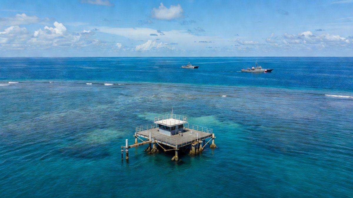
A movable platform documented by Philippine authorities at Bajo de Masinloc (Global 1 News)
The recent placement of a movable platform by Chinese vessels in Bajo de Masinloc has raised fresh concerns over unauthorized maritime activities in Philippine waters. Officials from the National Maritime Council confirmed that the structure appeared without Manila's approval, marking the first documented instance of such equipment at the shoal. This development comes amid ongoing efforts by Philippine agencies to monitor activities within the exclusive economic zone.
Timeline of Detection and Initial Monitoring
Philippine authorities first detected signs of the platform through commercial satellite imagery on May 20, when no man-made structure was visible at the southeast entrance of Bajo de Masinloc. By May 21, two Chinese research vessels identified as Yusha Yuji 20028 and Yuzan Yuji 6 were observed at the same location, leading officials to suspect they had transported the equipment. The National Maritime Council spokesperson Alexander Lopez noted during a June 11 interview on PTV's Bagong Pilipinas Ngayon that monitoring began as early as May 20 or 21.
The Bureau of Fisheries and Aquatic Resources documented the platform during a routine maritime domain awareness flight on May 26, followed by low-altitude images captured by the Philippine Coast Guard on May 28. These steps highlight the coordinated response among multiple agencies including the BFAR, PCG, Armed Forces of the Philippines, Philippine Navy, and Philippine Air Force. Such patrols continue to ensure awareness of developments in the area.
Further observations showed six Chinese nationals on the deck by May 30, with the platform shifting position inside the shoal on May 31 supported by two service boats. This sequence of events underscores the rapid deployment and the challenges of responding to activities that occur without prior notification to Manila. The monitoring process reflects the government's commitment to protecting its maritime domain through consistent aerial and sea-based efforts.
For coastal communities in Zambales, these documented movements serve as a reminder of how distant activities can influence daily maritime routines. Fisherfolk who rely on the waters around Bajo de Masinloc for their livelihood watch these developments closely, aware that unauthorized structures may affect access to traditional fishing grounds. The timeline of detection demonstrates the value of sustained vigilance by Philippine agencies in safeguarding resources that sustain families across the province.
Physical Characteristics of the Movable Platform
The platform measures approximately 30 square meters in deck area and spans five to seven meters in length, featuring fenders around its perimeter and four metal poles at each corner believed to function as stilts when stationary. Philippine Coast Guard Rear Adm. Jay Tarriela described this as the first documented movable platform at Bajo de Masinloc, distinguishing it from fixed installations previously observed in other areas. Its compact design allows for relocation, which officials assess as suited for temporary maritime research operations.
By May 25, satellite imagery revealed a square object near the southeast entrance, confirming the structure's presence after the arrival of the two research vessels. This mobility raises questions about how such equipment can be repositioned quickly within the shoal without detection in real time. The design elements suggest an intent for data collection that can be adjusted based on environmental conditions or operational needs.
Analysts within the National Maritime Council view the platform's features as indicative of systematic information gathering that bypasses required authorizations. The presence of personnel on deck further points to active management of the equipment during its initial placement. These details provide concrete evidence of activities that Philippine officials argue fall under the regulatory authority of the coastal state.
Families in nearby provinces understand that even small structures like this one can signal broader patterns of presence that limit traditional navigation routes. The platform's size and setup, while modest, represent a tangible change in the seascape that affects how local mariners plan their voyages. Community leaders in Zambales often discuss how such additions accumulate over time and shape the everyday realities of those who depend on the sea.
Legal Framework and Philippine Assertions
Under the United Nations Convention on the Law of the Sea, maritime surveys and research activities within the exclusive economic zone require explicit authorization from the coastal state. Alexander Lopez emphasized that any such operations by foreign entities amount to unauthorized extraction of data, stating that the actions practically involve taking information without consent. Bajo de Masinloc lies 100 to 119 nautical miles from Zambales, placing it firmly inside the Philippines' 200-nautical-mile exclusive economic zone and more than 500 nautical miles from China's Hainan province.
The Department of Foreign Affairs has lodged diplomatic protests and demarches, calling on China to remove the platform immediately. DFA maritime affairs spokesperson Rogelio Villanueva Jr. affirmed the Philippines' indivisible, incontrovertible, and longstanding sovereignty and jurisdiction over the shoal. These statements align with the 2016 arbitral award and the 2002 Declaration on the Conduct of Parties in the South China Sea, both of which underscore the need for consent in such matters.
Officials stress that only the Philippines holds the right to place structures or conduct activities at Bajo de Masinloc. The continued presence of the platform without approval violates these established principles and creates friction in regional maritime governance. This legal stance forms the foundation of Manila's response, focusing on peaceful assertion of rights through established international channels.
Residents along the western seaboard feel the weight of these legal principles in their daily lives, as fishing communities have long operated under the understanding that the exclusive economic zone belongs to the nation. The emphasis on authorization protects not only territorial claims but also the economic activities that support generations of Filipino families. Such assertions resonate deeply in barangays where the sea represents both heritage and sustenance.
Diplomatic Actions and Internal Assessment
The DFA's formal communications with Beijing seek the prompt withdrawal of the platform and cessation of related activities. These steps occur alongside continued internal monitoring rather than immediate appeals to external partners. Alexander Lopez indicated that at this stage, the focus remains on domestic capabilities, with the government assessing whether the platform signals additional intentions from the other side.
President Ferdinand Marcos Jr. has reinforced the position that not even a square inch of Philippine territory will be relinquished, a message delivered during one of his State of the Nation Addresses. This commitment guides the measured approach taken by agencies involved in maritime domain awareness. The strategy prioritizes documentation and diplomatic channels while maintaining readiness through existing patrol assets.
By keeping assessments internal initially, Manila aims to build a comprehensive understanding before expanding coordination. This measured pace allows for careful evaluation of implications without escalating tensions prematurely. The approach reflects a preference for legal and peaceful defense of maritime rights as outlined by national leadership.
Local government units in affected provinces often coordinate with national agencies to relay updates to their constituents, ensuring that fishing communities receive timely information. Such collaboration strengthens the link between policy decisions in Manila and the lived experiences of those whose work takes them closest to the shoal. The internal focus reassures many that responses are grounded in direct knowledge of conditions on the water.
Human Impact on Coastal Communities
Fisherfolk from Zambales and surrounding areas have long navigated the waters around Bajo de Masinloc as part of their regular routes, relying on these grounds for catches that sustain household incomes. The appearance of the platform introduces uncertainty about future access and safety during routine voyages. Community members express concern that unauthorized data collection could indirectly influence resource management decisions that affect their catches.
Children in coastal barangays grow up hearing stories of the shoal from elders who have fished there for decades, embedding a sense of connection to these waters. Any development that occurs without Philippine involvement disrupts this intergenerational link and raises questions about long-term stewardship. The human stories behind the monitoring reports remind officials and citizens alike of the personal stakes involved.
Women in fishing households often manage the economic side of the trade, from selling catches to supporting family needs during lean seasons. Disruptions at sea translate directly into household budgeting challenges that ripple through entire communities. The platform's presence, though distant in physical terms, connects to these everyday pressures faced by families who contribute to the nation's food supply.
Barangay captains in the region frequently organize discussions to share information gathered from national patrols, helping residents understand how diplomatic efforts protect their interests. This grassroots engagement ensures that the broader implications of maritime activities reach those most directly affected. The focus on human impact keeps the conversation centered on people rather than abstract boundaries alone.
Broader Regional Context and Future Vigilance
The placement of the platform occurs against the backdrop of established Philippine commitments to uphold the 2016 arbitral award and regional agreements on conduct in the South China Sea. Continued patrols by multiple agencies demonstrate sustained attention to developments that could affect the wider maritime environment. Officials remain open to evaluating any signals of expanded activity while prioritizing internal capabilities.
Analysis by the National Maritime Council suggests that such structures may serve purposes beyond immediate data collection, though assessments continue without premature conclusions. The emphasis on peaceful and legal responses aligns with the nation's broader foreign policy orientation. This stance seeks to maintain stability while firmly protecting recognized rights under international law.
For the Philippine public, these events reinforce the importance of awareness about exclusive economic zone boundaries and the activities permitted within them. Educational efforts in schools and community centers often highlight how maritime issues connect to national identity and economic resilience. The ongoing situation provides a concrete example for discussions on sovereignty that resonate across generations.
Ultimately, the response from Manila centers on protecting the interests of citizens whose lives intersect with these waters daily. Through consistent monitoring and diplomatic engagement, the government works to ensure that future activities respect established rules. This approach reflects a deep commitment to the welfare of coastal populations and the preservation of maritime heritage for years ahead.
By Bella Reyes, Staff WriterWhat's Your Reaction?
 Like
0
Like
0
 Dislike
0
Dislike
0
 Love
0
Love
0
 Funny
0
Funny
0
 Wow
0
Wow
0
 Sad
0
Sad
0
 Angry
0
Angry
0
Philippines/Southeast Asia Correspondent at Global1.News. Manila-based journalist covering Philippine politics, environment, maritime security, and social issues. Passionate about marine conservation and the communities protecting the Philippines' natural heritage.


Comments (0)