AI GPS Tracking Reduces Bear Encounters Across Japan
The Rising Frequency of Bear Encounters in Japan Bear encounters have increased across multiple Japanese prefectures in recent years, driven by environmental shifts and habitat pressures. The Ministry of the Environment compiles national encounter data and works with prefectural governments in regions such as Akita, Iwate, Toyama, Nagano, and Gifu to coordinate responses. Japan
The Rising Frequency of Bear Encounters in Japan
Bear encounters have increased across multiple Japanese prefectures in recent years, driven by environmental shifts and habitat pressures. The Ministry of the Environment compiles national encounter data and works with prefectural governments in regions such as Akita, Iwate, Toyama, Nagano, and Gifu to coordinate responses. Japan’s two primary bear species—brown bears (higuma) in Hokkaido and Asian black bears (tsukinowaguma) on Honshu and Shikoku—now appear more frequently near human settlements.
Contributing factors include changing climate patterns that affect food availability in mountainous areas, combined with gradual expansion of residential zones into former forest edges. These conditions have prompted prefectural authorities to seek technology-based solutions rather than relying solely on traditional patrol methods.
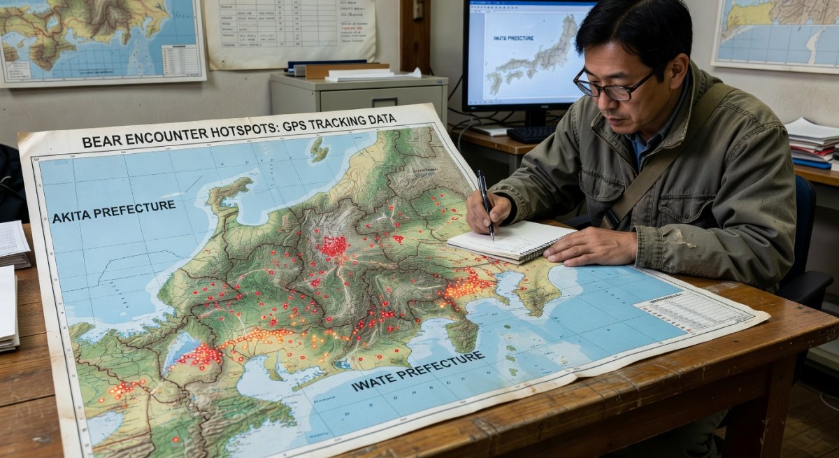
GPS Tracking Collars and Real-Time Movement Data
GPS collars deployed on selected bears transmit location coordinates at regular intervals, allowing researchers to map movement corridors and identify seasonal habitat use. The collars operate on low-power semiconductor platforms suited for remote mountainous terrain where battery replacement is difficult. Data streams feed into centralized databases managed through partnerships between the Ministry of the Environment and prefectural wildlife divisions.
By analyzing repeated movement patterns, authorities can determine which valleys or ridgelines serve as primary travel routes between feeding areas and den sites. This spatial information supports targeted placement of warning signs and temporary trail closures during high-activity periods. Edge-computing nodes installed at field stations process collar data locally before transmission, reducing latency and conserving bandwidth in areas with limited cellular coverage.
AI Predictive Models for Encounter Probability
The AI model highlighted in the NHK BOSAI segment integrates multiple environmental datasets to generate encounter-risk forecasts. Inputs include temperature and precipitation records, mast production surveys that track acorn and beechnut yields, and habitat condition metrics derived from satellite imagery. These variables are processed through machine-learning algorithms trained on historical encounter logs maintained by prefectural governments.
Output maps assign probability scores to specific grid cells, indicating elevated risk zones for the coming weeks or months. When mast production is low in a given year, the model typically elevates risk estimates near lower-elevation settlements as bears seek alternative food sources. Accuracy improves as additional collar data and ground observations are incorporated into retraining cycles. The Ministry of the Environment has supported pilot deployments of these models in coordination with the Digital Agency’s infrastructure initiatives for environmental monitoring.
Alignment with Japan’s Society 5.0 Vision
Japan’s Society 5.0 framework explicitly promotes the application of AI and IoT technologies to address societal challenges, including human-wildlife coexistence. The bear-management projects illustrate this approach by combining sensor networks, predictive analytics, and automated alert systems. METI’s semiconductor strategy supports development of energy-efficient chips that enable long-term deployment of field devices without frequent maintenance.
The Digital Agency’s role in standardizing data-exchange protocols between central and local governments facilitates wider adoption of the AI models. This policy linkage ensures that encounter forecasts generated in one prefecture can inform planning in neighboring regions that share similar ecological conditions. The result is a scalable national capability rather than isolated local experiments.
Practical Implications for Communities and Wildlife Managers
Local governments now receive weekly risk bulletins that guide decisions on trail access, garbage collection schedules, and resident advisories. In Akita and Gifu, for example, automated early-warning systems linked to the AI outputs send push notifications to registered residents when probability thresholds are exceeded. These measures reduce reliance on reactive responses after an incident occurs.
Wildlife managers use collar data to evaluate the effectiveness of habitat interventions such as supplemental feeding stations placed away from populated areas. Over time, the combined GPS and AI system supports evidence-based adjustments to hunting regulations and protected-area boundaries. Communities gain practical tools that balance safety with conservation objectives.
Expert Perspectives and Future Development Outlook
Researchers involved in the NHK BOSAI coverage emphasize that continued refinement of mast-production monitoring remains essential for model improvement. Integration of additional IoT sensors measuring soil moisture and forest canopy density is under discussion. Such enhancements would further increase forecast precision during atypical weather years.
Future phases may incorporate real-time camera-trap imagery processed at the edge to validate AI predictions on the ground. The Ministry of the Environment continues to evaluate cost-sharing frameworks that would allow smaller municipalities to access the same analytical tools used in larger prefectures.
Key Developments to Monitor in Upcoming Seasons
Observers should watch for expanded collar deployments in Hokkaido brown-bear populations and the release of updated national encounter statistics from the Ministry of the Environment. Any announcements regarding new Digital Agency-funded pilot sites will indicate the pace of nationwide rollout. Seasonal mast surveys conducted each autumn will provide early signals of potential risk elevation for the following spring and summer.
These technology-driven countermeasures represent a measured response to an evolving ecological challenge, grounded in Japan’s broader commitment to data-informed environmental management.
By Kenji Tanaka, Staff Writer
What's Your Reaction?
 Like
0
Like
0
 Dislike
0
Dislike
0
 Love
0
Love
0
 Funny
0
Funny
0
 Wow
0
Wow
0
 Sad
0
Sad
0
 Angry
0
Angry
0
Japan Correspondent at Global1.News. Tokyo-based voice covering Japanese politics, technology, economy, and culture. Tracks the intersection of tradition and innovation in one of the world's most dynamic societies.


Comments (0)