Typhoon Francisco Intensifies Rapidly, Signal No. 1 Up in Northern Luzon
<p>ANC 24/7 reported on June 22 that Typhoon Francisco had rapidly strengthened over the Philippine Sea, prompting PAGASA to raise Tropical Cyclone Wind Signal No. 1 in parts of Northern Luzon while t
ANC 24/7 reported on June 22 that Typhoon Francisco had rapidly strengthened over the Philippine Sea, prompting PAGASA to raise Tropical Cyclone Wind Signal No. 1 in parts of Northern Luzon while the southwest monsoon brought gale-force gusts across wide areas of the country. The broadcast detailed how the storm's center sat 620 kilometers east of Tuguegarao City by 11 AM, with maximum sustained winds now at 155 kph.
Typhoon Francisco Intensifies Rapidly, Signal No. 1 Up in Northern Luzon
Manila, Philippines — PAGASA recorded at 5 AM on June 22 that Typhoon Francisco was centered 715 km east of Tuguegarao City, Cagayan, with maximum sustained winds of 140 kph and gusts up to 170 kph. The storm moved west-northwest at 30 kph under a central pressure of 965 hPa. By 11 AM the same day, the center had shifted to 620 km east of Tuguegarao City as winds intensified to 155 kph with gusts reaching 190 kph and forward speed slowed to 15 kph west-northwest.

Typhoon Francisco Intensifies Over the Philippine Sea
PAGASA forecasters noted the storm's quick strengthening between the two observations on June 22, with central pressure dropping and sustained winds climbing 15 kph in six hours. This intensification occurred while the system remained over warm waters east of Cagayan, allowing it to organize its circulation more tightly. Residents in coastal barangays of Gonzaga and Santa Ana already reported stronger afternoon winds whipping through coconut groves and sari-sari store awnings.
Fisherfolk families in the Babuyan Islands prepared their bancas earlier than usual after hearing the updated advisory. Many households in Camiguin Island recalled how past storms with similar wind speeds damaged nipa roofs and scattered fishing gear across the shoreline. The Philippine Coast Guard station in Aparri logged increased radio traffic from vessels seeking shelter in the hours after the 11 AM bulletin.
Local officials in Batanes emphasized that the current track could still shift slightly westward, bringing the core closer to the northernmost provinces. Community leaders in Basco organized quick checks of evacuation centers that had last been used during previous typhoon seasons. Farmers in the foothills of the Sierra Madre in Isabela began securing their rice seedlings against the expected increase in rainfall once the outer bands arrive.
Signal No. 1: Who Is Affected and What It Means
PAGASA raised Tropical Cyclone Wind Signal No. 1 at 11 AM on June 22 for the entire province of Batanes, the northeastern portion of Cagayan including the municipalities of Gonzaga and Santa Ana, and the eastern Babuyan Islands consisting of Babuyan, Didicas, and Camiguin Islands. Under this signal, winds of 39 to 61 kph are expected within 36 hours, enough to damage light materials and pose risks to small sea craft. The agency warned that peak intensity could reach super typhoon strength by Tuesday, June 23.
In Gonzaga, barangay captains conducted door-to-door visits to remind families to secure galvanized iron sheets and check drainage canals before the first rain bands reach the coast. Fisherfolk in Santa Ana tied down their outrigger boats at the municipal port after the Philippine Coast Guard issued its no-sail reminder. Schools in the affected Babuyan Islands announced early dismissal so students could help their parents prepare homes.
The signal also covers areas where coconut farmers fear losing harvests if gusts exceed 60 kph for several hours. In Batanes, the Ivatans community drew on bayanihan traditions to stack sandbags around low-lying homes near the shoreline. Local radio stations in Tuguegarao City broadcast the exact list of municipalities under Signal No. 1 every hour to ensure no household missed the update.
Southwest Monsoon Enhanced: Nationwide Impacts
The southwest monsoon enhanced by Typhoon Francisco produced gale-force gusts over La Union, Pangasinan, CALABARZON, Romblon, Masbate, most of the Visayas, the Zamboanga Peninsula, Misamis Occidental, Lanao del Norte, Camiguin, Surigao del Norte, Dinagat Islands, Davao Occidental, and Davao Oriental on June 22. PAGASA reported cloudy skies with scattered rains across Palawan, the Visayas, and Mindanao as the monsoon flow strengthened. These conditions are expected to persist while Francisco remains east of Luzon.
In Pangasinan, rice farmers in the lowlands near the Agno River checked irrigation canals after forecasters warned of possible flooding from sustained monsoon rains. Fisherfolk in Romblon and Masbate hauled their boats higher onto the beach as waves reached 2.5 meters. In the Zamboanga Peninsula, vegetable vendors at public markets reported slower sales because residents stayed indoors during the gusty afternoon showers.
Residents of Surigao del Norte and Dinagat Islands experienced rough coastal waters that prevented inter-island pump boats from operating on their regular schedules. In Davao Oriental, upland communities prepared for possible landslides after the ground became saturated from repeated monsoon downpours. The Department of Social Welfare and Development regional offices in these areas stood ready to distribute relief goods if flooding worsens in the coming days.
PCG No-Sail Policy and Danger to Fisherfolk
The Philippine Coast Guard enforced a no-sail policy in parts of Northern Luzon following the 11 AM PAGASA bulletin, citing rough seas up to 3.5 meters along the eastern seaboards of the Babuyan Islands, mainland Cagayan, Batanes, and Isabela. Moderate to rough seas were also reported in Northern Luzon, Bicol, Eastern Visayas, and Eastern Mindanao, affecting daily livelihood activities of thousands of small-scale fishers. PCG personnel at the Aparri and San Vicente stations boarded vessels to ensure compliance.
In Camiguin Island, families who rely on daily fishing trips for their income faced immediate loss of earnings as the no-sail order took effect. Many turned to alternative work such as repairing nets and mending boats while waiting for the seas to calm. The Coast Guard advised operators of larger commercial vessels to remain in port until the gale-force monsoon winds subside.
Barangay officials in coastal Cagayan coordinated with the Philippine Coast Guard to post additional lookouts at popular launch sites. Fisherfolk associations in Isabela reminded members that past violations of similar advisories had led to capsized boats and loss of life. The policy is expected to remain in place at least until Francisco exits the Philippine Area of Responsibility on June 25 or 26.
Preparations and Government Response
DSWD prepositioned relief goods including rice, canned sardines, and instant noodles at its regional warehouse in Tuguegarao City on June 22 to serve families that may need evacuation. Barangay officials across Signal No. 1 areas performed door-to-door checks to identify vulnerable households, particularly those living in nipa huts near riverbanks. Local government units also advised residents to inspect their roofs and clear drainage systems before the expected heavy rains.
In Batanes, the provincial disaster risk reduction office activated its emergency operations center and tested radio communications with all municipalities. The Department of Health regional office in Tuguegarao City reminded hospitals to stock additional medicines for possible injuries from flying debris. NDRRMC coordinated with DPWH district offices to position heavy equipment near known flood-prone roads in Cagayan and Isabela.
Community volunteers in Santa Ana organized bayanihan sessions to help elderly residents board up windows. Sari-sari store owners in Gonzaga reported increased purchases of candles, batteries, and canned goods as families followed the government advisory to prepare for possible power outages. These localized efforts complement the larger prepositioning of supplies by national agencies.
Economic Impact on Agriculture and Fisheries
The agricultural sector in Northern Luzon faces significant risks as Typhoon Francisco approaches at the tail end of the planting season. The Department of Agriculture in Cagayan Valley reported that rice and corn farmers in Gonzaga and Santa Ana have already begun emergency harvesting of crops that are near maturity to minimize potential losses from heavy rains and strong winds. Coconut farmers in the Babuyan Islands face particular danger, as gusts exceeding 60 kph can strip trees of fruit and damage trunks, setting back production for an entire growing season.
Fisherfolk in Batanes and Cagayan face the most immediate economic disruption, as the PCG no-sail policy halts the daily fishing operations that feed families and supply local markets. In small coastal communities like those on Camiguin Island and Didicas Island, a single week without fishing can strain household budgets that operate on thin margins. The National Fisheries Research and Development Institute noted that rough seas during monsoon seasons typically reduce municipal fishing output by 40 to 60 percent in affected regions.
Local vendors in Tuguegarao City's public market reported reduced supplies of fresh fish on Monday as the no-sail policy took effect. Prices of galunggong and bangus rose by 15 to 20 pesos per kilo in some stalls, according to market vendors. The Department of Trade and Industry regional office said it is monitoring price movements and will coordinate with the National Food Authority to ensure stable food supply if the weather disruption extends beyond the week.
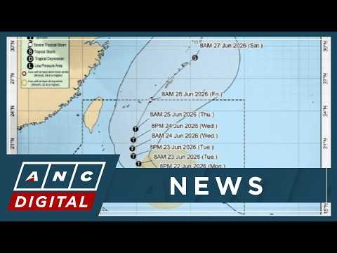
Forecast Track and What to Watch For
PAGASA forecast that Typhoon Francisco will reach peak intensity on Tuesday, June 23, with a possibility of attaining super typhoon category before it begins to weaken. The storm is expected to exit the Philippine Area of Responsibility between Friday, June 25, and Saturday, June 26. A slight westward shift in the track remains possible, which could bring the center closer to Extreme Northern Luzon and increase direct impacts on Batanes and northern Cagayan.
Residents in the Babuyan Islands were advised to monitor subsequent PAGASA bulletins every six hours for any changes in the forecast track. Local officials in Tuguegarao City urged families to identify evacuation routes in case river levels rise rapidly from monsoon-enhanced rainfall. The agency also warned that even if the core stays offshore, the enhanced southwest monsoon could still produce flooding in low-lying areas of Visayas and Mindanao through the weekend.
Communities across Northern Luzon continued to stock basic supplies while waiting for the next update. Fisherfolk associations planned to resume operations only after the Philippine Coast Guard lifts the no-sail policy. PAGASA emphasized that timely preparation remains the most effective defense against the combined effects of the typhoon and the monsoon. With the storm expected to reach its peak strength within hours and the southwest monsoon extending its reach across the archipelago, the coming days will test the preparedness of communities from Batanes to Davao Oriental.
By Bella Reyes, Staff Writer
What's Your Reaction?
 Like
0
Like
0
 Dislike
0
Dislike
0
 Love
0
Love
0
 Funny
0
Funny
0
 Wow
0
Wow
0
 Sad
0
Sad
0
 Angry
0
Angry
0


Comments (0)