
South Korea's CAS500-4 Satellite Advances Agricultural Sovereignty
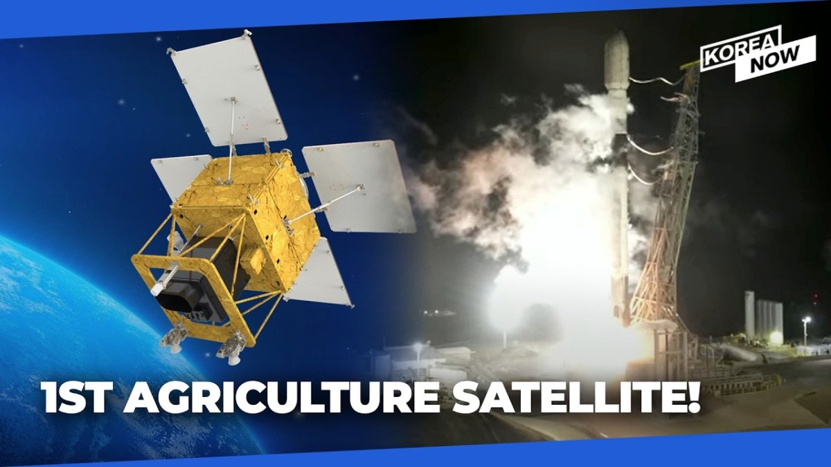
Launch Marks Milestone in Domestic Satellite Development South Korea achieved a significant step in its space program with the successful deployment of the CAS500-4 satellite on July 7, 2026, at 4:10 PM KST. The 514-kilogram spacecraft lifted off from Vandenberg Space Force Base aboard a SpaceX Falcon 9 rocket as part of a rideshare mission carrying more than eighty additional
Launch Marks Milestone in Domestic Satellite Development
South Korea achieved a significant step in its space program with the successful deployment of the CAS500-4 satellite on July 7, 2026, at 4:10 PM KST. The 514-kilogram spacecraft lifted off from Vandenberg Space Force Base aboard a SpaceX Falcon 9 rocket as part of a rideshare mission carrying more than eighty additional satellites. This event underscores Seoul's commitment to building independent Earth-observation infrastructure tailored to national priorities in agriculture and forestry.
The Korea Aerospace Research Institute (KARI) led technical development while Korea Aerospace Industries (KAI) served as the prime contractor. The Korea AeroSpace Administration (KASA) coordinated launch logistics with U.S. authorities. This division of labor reflects a maturing domestic supply chain that reduces reliance on foreign prime contractors for medium-class satellites.
Technical Specifications and Operational Capabilities
CAS500-4 carries a wide-area electro-optical camera delivering five-meter resolution imagery across a 120-kilometer swath. These parameters enable complete coverage of the Korean Peninsula every three days, providing consistent temporal resolution essential for seasonal crop monitoring. The Rural Development Administration and Korea Forest Service, both under the Ministry of Agriculture, Food and Rural Affairs (MAFRA), will operate the satellite and process its data streams.
Applications include crop-yield forecasting, agricultural water-resource management, forest-resource assessment, disaster response, and climate-change impact analysis. Unlike earlier CAS500 missions that served broader remote-sensing needs, CAS500-4 represents the first platform dedicated exclusively to agriculture and forestry requirements, aligning sensor design directly with MAFRA policy objectives.
Food Security as a Dimension of Geopolitical Strategy
Seoul has long treated food security as a strategic vulnerability given the peninsula's limited arable land and exposure to climate variability. CAS500-4 supplies high-frequency, domestically controlled data that supports science-based policy interventions, from precision irrigation scheduling to early detection of pest outbreaks. This capability strengthens South Korea's position in regional agricultural trade negotiations and reduces dependence on external weather or yield data sources.
Integration of satellite-derived metrics into MAFRA decision frameworks also facilitates more accurate subsidy allocation and export planning. In an era of supply-chain disruptions, such tools contribute to national resilience without requiring expansion of physical farmland.
International Partnerships and Technological Sovereignty
The choice of a U.S. launch site and commercial Falcon 9 vehicle illustrates pragmatic international cooperation. South Korea gains reliable access to orbit while continuing to develop indigenous launch vehicles for future missions. This hybrid approach mirrors strategies employed by other middle powers seeking to accelerate capability growth without full vertical integration.
CAS500-4 follows CAS500-1, launched in March 2021, and CAS500-2, which reached orbit on May 3, 2026, after an earlier Russian launch opportunity was cancelled. The progression demonstrates sustained program momentum despite shifting geopolitical conditions affecting launch-provider availability.
Comparative Context Within Global Agricultural Satellite Programs
Other nations operate dedicated agricultural monitoring constellations, yet CAS500-4 occupies a distinct niche through its exclusive focus on temperate-zone crops and forest management relevant to the Korean Peninsula. European Sentinel-2 satellites provide broader multispectral coverage but operate under multinational governance structures. India's Resourcesat series emphasizes national food-grain estimation yet serves a vastly larger land area. South Korea's medium-class platform offers higher revisit frequency over a compact territory, optimizing data utility for intensive farming systems typical of East Asia.
These design choices position South Korea as a potential exporter of tailored agricultural remote-sensing services to countries with similar topographic and climatic profiles.
Implications for Inter-Korean Agricultural Monitoring
Regular, high-resolution imagery of the entire peninsula creates new possibilities for tracking agricultural conditions north of the demilitarized zone. While direct data sharing remains constrained by political realities, the satellite's unclassified outputs could support indirect confidence-building measures or humanitarian planning in the event of future agricultural crises in the North. Historical precedents, such as joint environmental monitoring proposals, suggest that technical data can occasionally transcend immediate political barriers when framed around shared ecological concerns.
Strategic Outlook for Korea's Space Economy
CAS500-4 advances South Korea's broader ambition to secure a larger share of the global space economy through specialized public-sector applications. By concentrating on agriculture and forestry, the program generates measurable returns in food security and disaster preparedness while nurturing industrial competencies transferable to commercial Earth-observation markets. Continued investment in subsequent CAS500-series satellites and planned geostationary meteorological assets will further consolidate these gains.
The satellite's operational phase will test the effectiveness of inter-agency data pipelines linking KARI, KASA, MAFRA, and the Korea Forest Service. Successful integration could serve as a template for future multi-ministry space applications, reinforcing South Korea's reputation for disciplined execution of medium-scale space projects.
By Prof. David Park, Staff Writer
This article was produced with AI-assisted research and editorial support. Reporting is based on sources cited in the article.
What's Your Reaction?
 Like
0
Like
0
 Dislike
0
Dislike
0
 Love
0
Love
0
 Funny
0
Funny
0
 Wow
0
Wow
0
 Sad
0
Sad
0
 Angry
0
Angry
0

East Asia/Technology Correspondent at Global1.News. Seoul-based voice covering Korean politics, technology, business, and culture. Analyzes how technology and geopolitics intersect across East Asia.














Comments (0)