
Hurricane Fausto Targets Hawaii - Islands Brace for Potential Impact
Listen up, folks, because this one is moving fast and it deserves your full attention right now. Hurricane Fausto is carving a path straight across the Pacific that puts Hawaii squarely in the crosshairs, and the islands are already shifting into high gear to get ready. This is not some distant weather story you can scroll past.
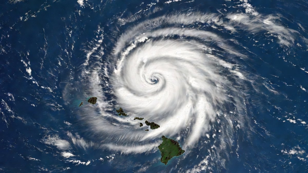
Listen up, folks, because this one is moving fast and it deserves your full attention right now. Hurricane Fausto is carving a path straight across the Pacific that puts Hawaii squarely in the crosshairs, and the islands are already shifting into high gear to get ready. This is not some distant weather story you can scroll past. It is the kind of situation that can turn daily routines upside down in a matter of days, and the details coming in demand we pay close attention together.
Hurricane Fausto Targets Hawaii - Islands Brace for Potential Impact
Dateline Honolulu - July 25, 2026. The latest track data shows Fausto holding steady as a Category 2 hurricane while it barrels west at 14 mph, with landfall windows opening around July 27-28. The National Hurricane Center cone sweeps across every major island except Kauai, and that alone tells you how broad the threat has become. I have watched these systems for years, and the combination of forward speed, intensity, and the trailing Genevieve behind it means we are looking at a compressed timeline that leaves little room for last-minute scrambling. The reality is simple: the Pacific is delivering another test, and Hawaii has to meet it head-on.
What We Know About Fausto Right Now
Fausto sits at Category 2 strength with sustained winds between 96 and 110 mph on the Saffir-Simpson scale. That places it firmly in the range where roof damage, power outages, and dangerous surf become the norm rather than the exception. It is moving west at 14 mph and is expected to reach the islands between July 27 and 28. The National Hurricane Center cone currently covers all islands except Kauai, which sits just outside the main envelope for now. The storm itself is slightly smaller than average, yet that compactness does not reduce the punch it can deliver once it arrives.
The Saffir-Simpson Hurricane Wind Scale classifies storms from Category 1 to 5 based solely on sustained wind speeds, with Category 2 representing dangerous winds that can cause extensive damage. In Hawaii’s context, this intensity often translates to storm surges of three to five feet along exposed coasts, widespread power outages lasting days, and uprooted trees that block evacuation routes. Coastal flooding risks rise sharply on south- and east-facing shores where wave run-up compounds the surge, while inland valleys may see flash flooding from the storm’s concentrated rainfall core.
At the 140 degrees west longitude handoff line, operational responsibility transfers from the National Hurricane Center in Miami to the Central Pacific Hurricane Center in Honolulu, allowing local forecasters to issue more granular watches and warnings tailored to island topography. Genevieve is already forming in its wake, which adds another layer of concern because any recovery effort could be interrupted before it even starts. The handoff line at 140 degrees west longitude is where the National Hurricane Center passes responsibility to the Central Pacific Hurricane Center in Honolulu, and Fausto is right on schedule to cross that boundary soon. Historically, Hawaii has seen only three Category 2 or stronger impacts in more than thirty years: Iniki in 1992, Lane in 2018, and Douglas in 2020. That rarity does not make the current threat any less real; it simply reminds us how infrequently these systems reach the islands at full strength.
Most East Pacific hurricanes weaken before reaching Hawaii because they encounter cooler sea-surface temperatures north of 20 degrees latitude and increased vertical wind shear that disrupts their circulation. These environmental factors explain why only a handful of systems have maintained Category 2 or greater strength upon arrival, making the current Fausto track an outlier that demands heightened vigilance from emergency officials and residents alike.
The Forecast: Where Is It Heading?
The GFS and ECMWF models both point to Fausto recurving northwestward in the coming days. Current probabilities show a 60 percent chance the center passes between Maui and Oahu, while the odds of hurricane-force winds actually affecting the islands sit near 45 percent. Those numbers matter because Hawaiian geography creates narrow windows where storms can either thread the needle through deep channels like the Alenuihaha Channel or get disrupted by the massive volcanic peaks that trigger orographic lifting and dump extreme rainfall on the windward slopes.
Orographic lifting occurs when moist air is forced upward over steep volcanic slopes, cooling rapidly and condensing into heavy precipitation. On Maui’s windward slopes, this process can generate 10 to 20 inches or more of rain in a 24-hour period, overwhelming drainage systems and triggering landslides. The Alenuihaha Channel, spanning roughly 26 miles between Maui and the Big Island, acts as a narrow corridor where the storm’s core could either intensify briefly over warmer channel waters or begin to fragment against the island masses on either side.
The 45 percent probability of hurricane-force winds represents a statistically significant risk when applied across the entire state, equating to roughly a coin-flip chance that at least one major island experiences sustained winds above 74 mph. Compare this setup to past storms and the differences stand out clearly. Iniki made a direct Category 4 landfall on Kauai and left lasting scars. Lane stalled south of the islands and produced record rainfall totals without a direct hit. Douglas weakened before arrival and spared the state major damage. Fausto sits somewhere in between those outcomes right now, and the track uncertainty is exactly what keeps emergency managers awake at night. The cone is the tool we watch, not the individual model runs that shift every six hours.
Both the GFS and ECMWF are medium-range global models whose accuracy improves markedly inside the 72-hour window; with Fausto now within that timeframe, forecasters place greater weight on the consensus track that shows a northwestward recurvature after initial approach. This convergence reduces some uncertainty but still leaves room for small shifts that could determine whether the center clips Oahu or slides south of the Big Island.
Why Size Matters - and Why It Doesnt
Fausto is running a little smaller than the average Pacific hurricane, and some people might think that lowers the odds of a direct hit on these small islands scattered across a huge ocean. That logic holds on paper, yet a compact storm can still unload concentrated rain and wind in a very tight footprint once it interacts with the terrain. The real issue is track uncertainty, not diameter. When the cone covers multiple islands, every coastal community has to treat the threat as personal rather than statistical.
Compact storms can intensify or weaken rapidly because their smaller circulation responds more quickly to changes in sea-surface temperatures and wind shear. In the Pacific, size and intensity are loosely correlated; a smaller storm may pack a tighter eyewall with higher localized winds even if its overall diameter is modest. Historical examples include Hurricane Dot in 1959 and Tropical Storm Flossie in 2013, both of which delivered concentrated damage despite modest size.
Emergency managers focus on the cone because that is where the highest probability of impacts lives. Measurements of size can shift with every satellite pass, but the steering pattern and forward speed are what determine whether homes lose power for days or whether roads become impassable from debris. The smaller size does not give anyone a pass; it simply changes the flavor of the impacts we should expect if the center stays on its current line.
A compact eyewall passing directly over populated areas such as Honolulu or Kahului could produce wind gusts exceeding 100 mph in a swath only a few miles wide, leading to highly localized but severe structural damage and prolonged power outages for tens of thousands of residents.
Preparing for the Worst, Hoping for the Best
Concrete steps are what separate preparation from panic. Stock water, batteries, non-perishables, and any prescription medications you or your family need for at least a week. Secure outdoor furniture and loose items that can become projectiles in 100-mile-per-hour winds. Know your evacuation zone and have a plan for where you will go if officials issue orders. Check on neighbors, especially older residents or anyone living alone, because small communities pull together fastest when everyone watches out for each other.
Residents should prepare a seven-day supply including one gallon of water per person daily, canned goods, a manual can opener, flashlights with extra batteries, a battery-powered radio, and a fully charged power bank. Fill vehicle gas tanks and have cash on hand, as ATMs may be inoperable. Generator users must operate units outdoors at least 20 feet from windows to avoid carbon-monoxide poisoning and never connect them directly to household wiring.
Honolulu evacuation routes prioritize H-1 and H-2 freeways toward higher ground in central Oahu, while Hilo residents head mauka along Highway 11 and Kahului evacuees use Highway 37 toward Upcountry Maui. Pet owners should pack carriers, leashes, food, and vaccination records for shelter access. Genevieve trailing behind means supplies need to cover a potential round two, so do not treat this as a single-storm event. Sign up for local alerts through your county emergency management office and review your insurance coverage before the first rain bands arrive. These small steps taken today beat the scramble that happens when the outer bands are already overhead. The islands have faced this before, and the communities that fare best are the ones that treat preparation as routine rather than optional.
When power outages extend for days, unplug sensitive electronics, use battery lights instead of candles, and check on refrigerated food every four hours to minimize spoilage. Community cooling centers open at designated schools and recreation facilities once winds subside.
The Bigger Picture: Hurricane Season 2026
NOAA released its seasonal forecast calling for 17 to 22 named storms, above the average of 15. They expect 9 to 11 hurricanes, compared with the average of 8, and 4 to 6 major hurricanes against an average of 4. La Nina conditions are suppressing wind shear across the basin while enhancing moisture, which creates a more favorable environment for development. The earliest Category 2 storm in the East Pacific this season formed in mid-June, and climate factors suggest more systems are forming farther east and tracking toward the Central Pacific than in neutral years.
Warmer sea-surface temperatures linked to long-term climate trends are enabling earlier tropical cyclone formation and allowing storms to maintain intensity farther north. Compared with the 2025 season, which produced 14 named storms and only two hurricanes reaching Hawaii’s vicinity, 2026’s elevated activity reflects stronger La Niña-driven suppression of shear. La Niña specifically reduces upper-level westerly winds that normally tear apart developing systems, thereby lengthening the period when storms can intensify before encountering cooler waters.
That broader pattern means Hawaii cannot view Fausto as an isolated event. The same steering currents and ocean temperatures that allow one storm to reach the islands can support additional systems in quick succession. Residents who have lived through multiple seasons know the drill, but newcomers and visitors need the same clear guidance. The season is running above average, and the window for impacts stretches well into the fall.
Long-range guidance through October suggests continued above-average activity, with potential for two to three additional systems to threaten the islands before the season concludes in November.
By Jessica Ali, Staff Writer
Check the latest National Hurricane Center cone this evening, grab the supplies you still need, and tell your neighbors what you are hearing. The next forty-eight hours will shape how this plays out, and staying informed together is the strongest move any of us can make right now.
This article was produced with AI-assisted research and editorial support. Reporting is based on sources cited in the article.
What's Your Reaction?
 Like
0
Like
0
 Dislike
0
Dislike
0
 Love
0
Love
0
 Funny
0
Funny
0
 Wow
0
Wow
0
 Sad
0
Sad
0
 Angry
0
Angry
0

Editor-in-Chief at Global1.News. Atlanta-based journalist who cuts through the BS and tells it like it is. Lead anchor, host, and the voice you hear when the spin stops and the truth starts.











Comments (0)