
Nan Province Devastated by Flash Floods, Pua District Hit Hardest
Flash floods from monsoon downpours swept through Thailand's Nan province on Wednesday, submerging homes in Pua district, collapsing a bridge on Highway 1256 and cutting off villages. Authorities issued cell broadcast warnings and opened evacuation centres as rescue teams reached stranded residents.
The mountains of Nan province woke to a roar on Wednesday morning that was not thunder, but the sound of water tearing through forested slopes and narrow valleys. By 8am, a heavy downpour had transformed the region's gentle streams into raging torrents, sending runoff cascading into residential areas and forcing rivers to burst their banks. For the people of Pua district and surrounding communities, the familiar anxiety of Thailand's monsoon season has once again become a lived reality, as flash floods swept through homes, collapsed bridges, and cut off entire villages from the outside world.
This is not the first time Nan has faced such devastation, and it will not be the last. But each flood season brings its own particular heartbreak — a family with a six-month-old baby awaiting rescue, an elderly patient needing evacuation, a farmer watching the season's work disappear under brown water. As authorities scramble to respond, the resilience of northern Thai communities is being tested once again.
Nan Province Devastated by Flash Floods as Monsoon Rains Trigger Widespread Inundation and Infrastructure Collapse
Bangkok, Thailand - Wednesday - The Nan Provincial Disaster Prevention and Mitigation Office reported Wednesday morning that heavy downpour began pounding the northern province at approximately 8am, triggering rapid runoff from forested highlands and causing rivers to overflow their banks. The flooding has affected multiple districts, with Pua district emerging as the hardest-hit area, where water levels in some properties almost completely submerged ground floors, according to local officials.

Emergency Response Underway as Affected Villages Identified
The Nan Provincial Disaster Prevention and Mitigation Office has confirmed that many residential areas in Pua district are inundated, with specific villages bearing the brunt of the flooding. Affected communities include Moo 2, 8 and 10 in tambon Ouan; Moo 3, 6 and 7 in tambon Woranakhon; Moo 1 and 5 in tambon Sila Laeng; Moo 2 in tambon Chai Wattana; and Moo 1, 4, 7 and 8 in tambon Pua. Floodwaters have entered numerous houses, and several roads have become impassable due to both flooding and landslides, complicating rescue efforts.
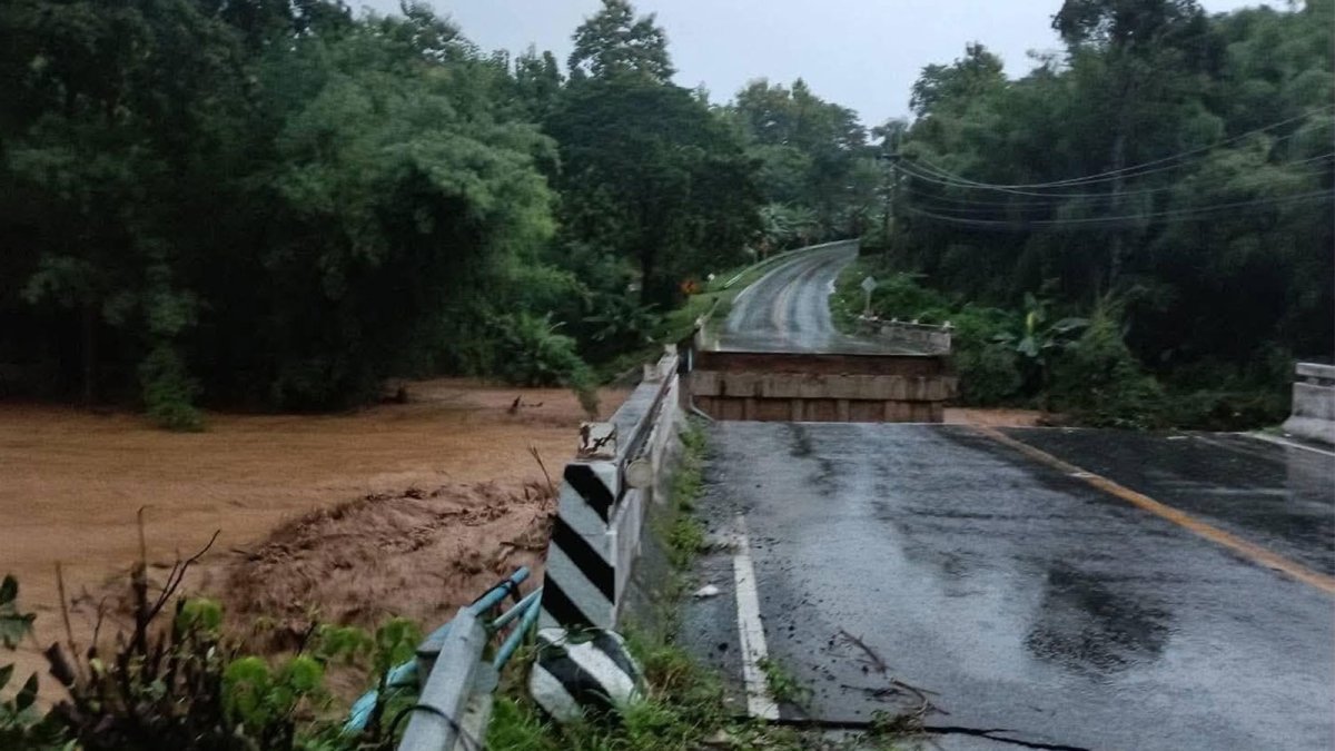
High waters have also been reported in Moo 11 in tambon Fai Kaeo of Phu Phiang district, as well as Moo 4 in tambon Muang Chang and Moo 1 in tambon Phong of Santisuk district. The Nan Provincial Public Relations office confirmed that a bridge in Pua district collapsed due to the heavy downpours, with photographic evidence released by the Nan Provincial Disaster Prevention and Mitigation Office showing the structural failure. Authorities are currently helping local residents evacuate and conducting preliminary damage assessments across the affected areas.
Cell Broadcast Warnings and Road Closures Across the Province
Earlier Wednesday morning, the Department of Disaster Prevention and Mitigation (DDPM) issued a Cell Broadcast warning specifically for flooding in Pua district, urging residents to immediately move their belongings to higher ground. This emergency alert system, which sends direct notifications to mobile phones in affected areas, represents a significant advancement in Thailand's disaster communication infrastructure, allowing authorities to reach residents within seconds of a threat being identified.
The Nan Highway Office 2 has reported several major road closures that are severely disrupting travel in the region. Highway 101 between Chang Phueak and Pua intersection remains flooded, while Highway 1371 between Teentok and Ban Mon area near Ban Fai bridge is also under water. Most critically, Highway 1256 in areas between Pua and Doi Phu Kha National Park has been rendered impassable after a bridge collapsed along the route. Officials have installed warning signs and safety equipment at affected locations, and motorists are being advised to avoid these routes entirely. For travellers heading to Bo Kluea, authorities recommend using Highway 1081 through Santisuk as an alternative route.
Thailand Context — Monsoon Season and the Northern Flood Cycle
This flooding event must be understood within the broader context of Thailand's annual monsoon cycle, which typically brings heavy rainfall to the northern region between August and October. The Northern Meteorological Centre issued a weather advisory at 7am Wednesday, forecasting light to moderate rain covering all districts of Nan and nearby provinces including Phrae, Phayao, Lampang, Lamphun and Chiang Rai. The rain is expected to move southwest, and officials are cautioning drivers about slippery roads and reduced visibility.
The Nan municipality has reported that more than 200 millimetres of rain fell in some areas — particularly Pua, Santisuk and Mae Charim districts — since midnight, a volume that overwhelmed drainage systems and natural waterways. Water levels in the Yao and Wa rivers continue to rise, and heavy to very heavy rain was continuing as of 6am Wednesday. The Irrigation Department is monitoring the situation, particularly after the Nalaw Weir, which it manages, suffered a collapsed wall caused by the strong current, which also damaged the adjacent road in Santisuk district.
This event echoes previous devastating floods in Nan, particularly those of 2006 and 2024, which the municipality has specifically referenced in its warnings. The Nan municipality has urged residents in communities at risk of flooding in Nan city to move belongings and vehicles to higher ground and to prepare to evacuate vulnerable people, with particular attention to areas that experienced flooding in those previous years. This institutional memory of past disasters is crucial for effective disaster preparedness in a region where monsoon patterns are becoming increasingly unpredictable.
Community Impact — Evacuation Centres and Rescue Operations
The human cost of this disaster is becoming clearer as rescue teams work through the day. In Pua district, a family with a six-month-old baby was among those requesting assistance, highlighting the particular vulnerability of young children during such emergencies. The Border Patrol Police 325 Chiang Klang have released photographs showing a disaster response team rescuing a man, a woman and a girl from a flooded area despite strong currents, demonstrating the bravery and dedication of local emergency services.
The Nan Provincial Public Relations office has announced the establishment of evacuation centres in Pua district to accommodate displaced residents. These centres include the Silaphet Community School Auditorium, Pua Municipality Auditorium, Pa Muet Temple in Sila Laeng Subdistrict Municipality, the area at the 3-way intersection entering Ban Don Chai, Woranakhon Subdistrict Administrative Organization and Chom Chaeng School, and Ban Siao School in Chai Watthana Subdistrict Administrative Organization. The use of Buddhist temples as evacuation centres reflects the deep integration of religious institutions in Thai community life, providing not just shelter but also a familiar and comforting environment for those displaced from their homes.
In Santisuk district, strong currents washed away one side of the Na Lao irrigation weir, damaging the road beside it, according to the Nan provincial public relations office. Ban Pang Chang in Pong subdistrict is among the affected communities, and the Phayaeng-Kiew Muang road towards the Nan provincial capital has been rendered impassable. A motorboat from the Pa Laeo Luang Subdistrict Administrative Organisation has been deployed to assist residents stranded near floodwaters in Ban Sri Bun Rueang, Pong subdistrict. Residents were also stranded on a bridge over the Muap stream at Ban Nam Song in Du Phong subdistrict, though all were brought to safety by rescue teams.
Regional Perspective — ASEAN Monsoon Impacts and Shared Vulnerabilities
For Thai readers and the wider ASEAN region, this flooding in Nan is a stark reminder of the shared vulnerabilities that come with living in Southeast Asia's monsoon belt. The same weather systems that bring life-giving rains to the region's rice paddies can, within hours, become destructive forces that claim lives and livelihoods. The Department of Disaster Prevention and Mitigation has urged local authorities to move vulnerable residents, including elderly people and bedridden patients, to safer locations — a priority that resonates across the region where ageing populations in rural communities face particular risks during natural disasters.
The flooding in Nan also has implications for regional trade and tourism. Nan province, while not a major international tourist destination, is increasingly popular with domestic travellers seeking authentic northern Thai culture and natural beauty, particularly around Doi Phu Kha National Park. The collapse of the bridge on Highway 1256 along the Pua-Bo Kluea route will disrupt access to these areas, potentially affecting local communities that depend on tourism revenue. For ASEAN neighbours like Laos, which shares a border with Nan province, such events highlight the interconnected nature of disaster risk in the Mekong subregion, where river systems and weather patterns transcend national boundaries.
Expert Perspectives — Official Responses and Community Resilience
Nan provincial officials have urged residents to remain alert from August 19 to 21, especially those in low-lying areas, near waterways or close to mountain slopes. The extended warning period reflects the ongoing nature of the threat, with continued rainfall expected over the coming days. People have been advised to move belongings and electrical appliances to higher ground, prepare for possible evacuation, and avoid flooded roads, damaged bridges and strong currents.
The DDPM has been coordinating with provincial authorities to ensure a comprehensive response. Residents staying home have been advised to prepare at least three days of food, drinking water and medicines, plus lighting, cooking and communication equipment. Authorities have also warned that electricity supplies could be suspended in some areas, adding to the challenges faced by affected communities. The main road between Pua and Chiang Klang has been closed to all vehicles, and the route between Pua and Bo Kluea has been cut off after a bridge was damaged, isolating some communities from emergency services.
Government agencies, local administrative organisations and rescue teams are monitoring conditions closely, with particular attention to young children, elderly people, patients and at-risk areas. The coordinated response involving multiple agencies — from the Border Patrol Police to local administrative organisations — demonstrates the strength of Thailand's disaster management framework, even as the scale of the challenge grows with each passing year.
What to Watch For
As the situation continues to evolve, several key factors will determine the trajectory of this disaster. The Northern Meteorological Centre's forecast of continued light to moderate rain across all districts of Nan and nearby provinces means that water levels in the Yao and Wa rivers are likely to remain elevated for the foreseeable future. The Nan provincial officials' warning for residents to remain alert from August 19 to 21 suggests that the peak of the flooding may not yet have passed.
Road closures, particularly the collapse of the bridge on Highway 1256, will complicate recovery efforts and may prolong the isolation of affected communities. The alternative route via Highway 1081 through Santisuk will face increased traffic, and authorities will need to ensure that this route remains passable. The damage to the Nalaw Weir, managed by the Royal Irrigation Department, raises concerns about water management infrastructure in the region and the potential for further structural failures if rainfall continues.
For the people of Nan, the coming days will be a test of endurance and community solidarity. The establishment of evacuation centres, the deployment of rescue teams, and the issuance of clear warnings reflect a disaster response system that has learned from past tragedies. But the true measure of recovery will come in the weeks and months ahead, as families return to damaged homes, farmers assess ruined crops, and communities begin the slow process of rebuilding.
As Thailand's monsoon season continues, the flooding in Nan serves as a sobering reminder of nature's power and the importance of preparedness. For Thai readers across the country, this event is not a distant news story but a reflection of shared vulnerability and resilience. The images of rescue workers wading through floodwaters to reach a family with a six-month-old baby, or the sight of a Buddhist temple opening its doors as an evacuation centre, speak to the enduring spirit of Thai communities in the face of adversity. The road to recovery will be long, but the people of Nan have faced such challenges before — and they will face them again with the same determination that defines the northern Thai character.
This article was produced with AI-assisted research and editorial support. Sources: Bangkok Post, Khaosod English, The Thaiger, Thai PBS World, Thai Rath.
By Ann Srisawat, Staff Writer
What's Your Reaction?
 Like
0
Like
0
 Dislike
0
Dislike
0
 Love
0
Love
0
 Funny
0
Funny
0
 Wow
0
Wow
0
 Sad
0
Sad
0
 Angry
0
Angry
0

Southeast Asia Correspondent at Global1.News. Based in Bangkok, covering Thai and Southeast Asian politics, economy, technology, and culture. Deep regional perspective on one of the world's most dynamic regions.














Comments (0)