
Khon Kaen to Declare Disaster Area After Seven Sinkholes
In the heart of Isaan, authorities in Khon Kaen are moving this week to declare Ban Wang Charoen a disaster area after seven sinkholes opened across farmland in Huai Muang subdistrict of Phu Pha Man district, disrupting rice cultivation and prompting immediate safety measures from the Royal Thai Government.
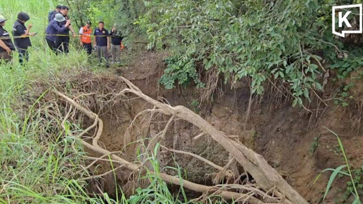
In the heart of Isaan, authorities in Khon Kaen are moving this week to declare Ban Wang Charoen a disaster area after seven sinkholes opened across farmland in Huai Muang subdistrict of Phu Pha Man district, disrupting rice cultivation and prompting immediate safety measures from the Royal Thai Government.
Sinkholes Appear in Ban Wang Charoen Farmland
Seven circular sinkholes formed in the fields of Ban Wang Charoen, Huai Muang subdistrict, Phu Pha Man district, Khon Kaen, with each measuring an average depth of 4-5 metres. Local officials from the Department of Mineral Resources Regional Office 2 joined geologists to inspect the sites this week after reports reached Khon Kaen Governor Khajornkiat Rakpanichmanee.
The collapses occurred in active rice paddies where farmers had been transplanting seedlings, directly affecting daily agricultural routines in this Isaan community known for its tight-knit village life and reliance on seasonal monsoon cycles.
Under Thai law the disaster-area declaration process begins with provincial assessment and moves to formal approval by the Ministry of Interior, unlocking targeted assistance such as emergency funding for farmland restoration and temporary relocation support for affected households. For rice farmers in Ban Wang Charoen this step means access to compensation that can offset lost seedlings and damaged soil, preserving the seasonal income that sustains entire families through the dry months ahead.
The Isaan region sits atop extensive limestone formations across the Khorat Plateau, making villages like Ban Wang Charoen especially prone to sinkhole formation when surface water infiltrates ancient fractures. Historical records from the Department of Mineral Resources show repeated incidents in similar terrain, reminding local communities that geological hazards form part of everyday rural life rather than isolated surprises.
Rice cultivation remains the economic backbone for households in Huai Muang subdistrict, where each rai of paddy supports both household consumption and sales at nearby markets. When sinkholes damage fields, the immediate loss extends beyond one harvest to affect seed reserves and community sharing networks that have long helped Isaan farmers weather natural setbacks.
Inspections by Department of Mineral Resources Regional Office 2
Director Oruma Summat of the Department of Mineral Resources Regional Office 2 in Khon Kaen led the on-site assessment alongside provincial officers. She confirmed that each sinkhole resulted from surface soil collapsing into pre-existing underground cavities formed over time.
Oruma Summat stated that the cavities show no signs of further underground expansion, allowing temporary filling with soil as an immediate step while longer-term solutions are prepared under Thai disaster management protocols.
The Department of Mineral Resources maintains regional offices across Thailand specifically to monitor geological hazards, providing technical expertise that provincial governments rely upon during events like the Ban Wang Charoen collapses. This systematic approach helps translate field observations into practical recommendations that protect both farmland and village infrastructure.
By confirming the cavities will not expand further, the inspection team offers reassurance that allows farmers to plan the next planting cycle with greater certainty. Such clarity from the Department of Mineral Resources supports the steady rhythm of Isaan agriculture, where timing of monsoon rains and field preparation directly determines household food security.
Coordination between the regional office and local officials reflects Thailand's layered disaster response system, in which scientific assessment precedes administrative action. This sequence ensures that measures taken in Phu Pha Man district align with national standards while addressing the specific limestone conditions found in Khon Kaen province.
Ancient Limestone Geology Behind the Collapses
Geologists from the Department of Mineral Resources explained that the sinkholes developed in ancient limestone layers fractured millions of years ago by tectonic movement. These natural cracks, combined with local soil conditions in Phu Pha Man district, led to the ground giving way in Ban Wang Charoen.
The area carries a documented history of recurring sinkholes due to its underlying limestone geology, a feature common across parts of the Khorat Plateau that shapes farming practices and water management in Isaan villages.
Limestone terrain across the Khorat Plateau has produced sinkholes in multiple provinces, creating a shared challenge for rural communities that depend on stable ground for irrigation canals and paddy bunds. Understanding this geological continuity helps Thai planners anticipate similar risks in neighbouring districts and allocate monitoring resources accordingly.
Land use practices such as seasonal flooding of rice fields can interact with natural fractures, gradually widening cavities over successive monsoons. In Ban Wang Charoen this interaction underscores the need for careful water management that respects both agricultural needs and the underlying limestone structure.
Comparisons with sinkhole events elsewhere in Southeast Asia reveal that Thailand's proactive inspection system, led by the Department of Mineral Resources, provides an early-warning advantage that many regional neighbours are still developing. This positions Khon Kaen as a case study for balanced land stewardship within ASEAN agricultural zones.
Warnings Issued to Watch for Bubbling Signs
Officials advised residents of Ban Wang Charoen and nearby Huai Muang subdistrict to monitor for bubbling water or air rising from the ground, indicators of possible underground cavities that could precede additional collapses. The Department of Mineral Resources Regional Office 2 distributed these guidelines directly to village leaders this week.
These practical alerts connect to longstanding Thai rural traditions of observing natural signs in the land, helping communities protect both their crops and the Buddhist temples that often stand at the centre of village life in Khon Kaen province.
Bubbling water signals trapped air or water movement within cavities, a visible cue that allows farmers to evacuate fields before further collapse occurs. By teaching residents to recognise this sign, the Department of Mineral Resources strengthens community-level preparedness that complements official monitoring efforts.
Village leaders play a central role in relaying these warnings through morning announcements and temple gatherings, ensuring even elderly farmers who may not read official notices receive timely information. This grassroots communication network remains vital in Isaan where personal relationships often determine how quickly safety advice reaches every household.
Staying alert to such signs also supports broader disaster preparedness across the region, where climate variability can intensify groundwater fluctuations that trigger geological movement. Thai authorities continue to refine these advisories so they remain practical for daily farm work rather than disruptive to it.
Resident Ranong Khaophuang Describes Her Experience
Ranong Khaophuang, a farmer in Ban Wang Charoen, noticed bubbles emerging in her four-rai rice field while transplanting seedlings and quickly moved to safety. She expressed concern over the sudden ground movement that threatened her season's harvest.
Ranong Khaophuang also raised questions about whether operations at a nearby limestone quarry might have played a role, though authorities including the Department of Mineral Resources have not established any connection between the quarry and the seven sinkholes.
Four rai of rice paddy represents a substantial portion of a typical Isaan household's annual production, directly influencing both food supply and cash income from surplus sales. When such land faces sudden damage, the ripple effects touch school fees, medical expenses, and contributions to village merit-making ceremonies that bind communities together.
Questions about nearby quarries reflect the careful attention Isaan farmers pay to changes in their surroundings, even when official findings point solely to natural limestone processes. This vigilance helps maintain open dialogue between residents and agencies like the Department of Mineral Resources as investigations continue.
The experience of Ranong Khaophuang illustrates how individual observations contribute to collective understanding of geological risks, reinforcing the value of listening to farmers who work the land every day. Their accounts guide future safety recommendations tailored to the realities of rice cultivation in Phu Pha Man district.
Governor Khajornkiat Rakpanichmanee Orders Disaster Declaration
Khon Kaen Governor Khajornkiat Rakpanichmanee announced that Ban Wang Charoen will be declared a disaster area following the identification of additional high-risk locations. Officials will cordon off dangerous zones and activate assistance measures under Thai law for affected families.
The declaration enables coordinated support from provincial agencies, reflecting the Thai emphasis on communal resilience in Isaan where neighbours often share resources during times of natural disruption.
Once declared, the disaster area status triggers specific assistance measures including soil rehabilitation grants and temporary income support for farmers whose fields are cordoned off. These provisions help families in Ban Wang Charoen maintain stability while geologists complete their assessments and plan longer-term solutions.
Cordoning dangerous areas protects both residents and livestock, preventing accidental injury in zones where further subsidence remains possible. Provincial teams work alongside village headmen to mark boundaries clearly, ensuring daily routines can resume safely around the affected paddies.
The governor's decision aligns with Thailand's national framework for rapid response to geological events, demonstrating how local leadership connects village concerns to broader administrative support. This linkage proves especially important in rural Khon Kaen where timely aid can prevent one season's setback from becoming a multi-year hardship.
Implications for Isaan Agriculture and Regional Stability
The events in Phu Pha Man district highlight ongoing geological challenges that influence rice production across the Isaan region, where farmland supports both local livelihoods and Thailand's position as a key ASEAN rice exporter. Temporary soil filling offers short-term relief while geologists continue monitoring.
For Southeast Asian readers, the Khon Kaen case underscores the value of sharing geological data among ASEAN neighbours facing similar limestone terrains, strengthening cross-border cooperation on land safety without affecting tourism routes or trade corridors in the near term.
Climate patterns that bring heavier monsoon rains can accelerate cavity formation in limestone areas, making consistent monitoring by the Department of Mineral Resources an essential component of long-term agricultural planning. Isaan communities benefit when such data informs decisions about crop rotation and irrigation infrastructure.
Land use practices that balance rice farming with geological awareness help sustain the productivity that underpins rural economies in Khon Kaen province. By combining scientific insight with traditional observation, villages like Ban Wang Charoen maintain both their harvests and their cultural connection to the land.
Overall, the sinkhole response in Huai Muang subdistrict illustrates Thailand's capacity to address natural hazards through coordinated action between central agencies, provincial leadership, and local residents. This approach supports stable food production and community well-being across the wider Isaan region for years to come.
By Ann Srisawat, Staff WriterThis article was produced with AI-assisted research and editorial support. Reporting is based on sources cited in the article.
What's Your Reaction?
 Like
0
Like
0
 Dislike
0
Dislike
0
 Love
0
Love
0
 Funny
0
Funny
0
 Wow
0
Wow
0
 Sad
0
Sad
0
 Angry
0
Angry
0

Southeast Asia Correspondent at Global1.News. Based in Bangkok, covering Thai and Southeast Asian politics, economy, technology, and culture. Deep regional perspective on one of the world's most dynamic regions.














Comments (0)