
Fuego Volcano Eruption Forces Evacuations in Guatemala
Fuego volcano in Guatemala erupted Monday, forcing evacuations of 250 people from villages on its slopes and leaving 1,700 in shelters. Red alerts in three municipalities affected 29,000 people as ash fell, closing schools and a key highway. INSIVUMEH later declared the eruptive phase over, but r...
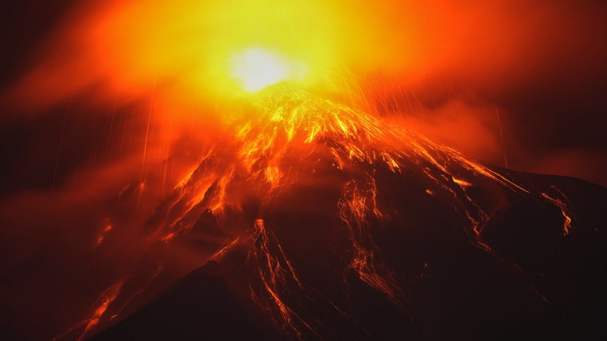
Residents near Guatemala's Fuego volcano watched as lava and ash burst from the slopes on Monday, sending families scrambling from their homes in El Porvenir and Las Lajitas. With pyroclastic flows racing down the southeastern flank and rain threatening to turn ash into mud, the human stakes remain high for those living in the shadow of one of the region's most active peaks. Guatemala's disaster response now faces a critical test of preparedness built from hard lessons.
Guatemala City, Guatemala — Fuego volcano, standing 3,768 meters high and located 45 kilometers from the capital and 16 kilometers west of Antigua, began spewing lava and ash on Monday. The national seismology institute INSIVUMEH reported a progressive reduction in activity by Wednesday and declared the eruptive phase that started August 3 finished. Conred, Guatemala's disaster management agency, coordinated evacuations and shelter support while monitoring ongoing risks from the stratovolcano.
The Eruption: Fire and Ash on Fuego's Slopes
Fuego, one of the most active volcanoes in the Western Hemisphere, triggered pyroclastic currents of gas, volcanic ash and rock fragments that flowed down its southeastern slope early Tuesday. INSIVUMEH tracked the flows as the government agency responsible for monitoring seismic and volcanic activity. The eruption placed the country on high alert, with ash clouds billowing and lava visible on the slopes.
Central America's position on the Pacific Ring of Fire makes such events a recurring reality for nations from Guatemala to Costa Rica. Communities here have long adapted to living alongside active geological forces, yet each eruption underscores the need for stronger regional coordination in disaster preparedness.
Villages Evacuated as Conred Raises the Alarm
Conred issued a nationwide orange alert, the second-highest level, and evacuated around 250 people from El Porvenir and the hamlet of Las Lajitas. About 1,700 people remained in shelters as of Wednesday, with evacuations set to continue until conditions improve. The agency urged residents to keep windows and doors closed, warned visitors and locals to avoid the volcano's slopes entirely, and distributed food to affected families.
The Education Ministry suspended classes in nearby towns, and schools close to the volcano cancelled lessons. In the small communities on Fuego's flanks, families gathered what they could carry, often leaving livestock and crops behind, as Conred protocols guided the move to temporary shelters.
For families who remember earlier eruptions, the shelter experience carries familiar weight. Parents comforted children while volunteers handed out meals and basic supplies, and Conred staff worked to support eventual returns once conditions eased. The orange alert that later became red in Sacatepéquez, Escuintla, and Chimaltenango underscored how quickly life can shift in these rural stretches near Antigua.
Red Alert: Ash Over Three Municipalities
Officials raised the alert to red in the municipalities of Sacatepéquez, Escuintla and Chimaltenango, where roughly 29,000 people face ashfall impacts. Schools in these areas stayed closed as ash continued to fall.
The red alert covers zones directly affected by the volcano's output, demonstrating how Guatemalan authorities prioritize targeted responses based on real-time monitoring. Ashfall blanketed the three departments in a region where coffee and sugar plantations sit alongside small farms and tourism routes leading to Antigua. The fine gray layer settled on fields and rooftops, forcing residents to adjust daily tasks such as tending crops and traveling to markets. Tourism around the UNESCO heritage site of Antigua also slowed as roads turned dusty and visibility dropped, squeezing local vendors and guides who depend on visitors from Guatemala City and beyond.
Conred executive director Claudinne Ogaldes advised residents to cover water deposits and wear face masks, protection rooted in the need to prevent ash from contaminating drinking supplies and irritating lungs during outdoor work. In coffee-growing areas, workers faced reduced visibility and the risk of ash settling on plants, threatening both immediate harvests and longer-term soil health. Public health concerns centered on breathing difficulties and water safety, especially for children and older residents who spend long hours in the fields.
Mudflows and the Race Against Rain
Authorities identified the next 72 hours as critical, with mudflows up to 7 kilometers long descending from the volcano and incoming rain expected to heighten risks. National Route 14, a major highway passing close to Fuego, was closed to traffic. No mudflows have reached villages yet and no structures have been damaged, according to Conred reports.
INSIVUMEH's declaration that the eruptive phase has ended offers some relief, yet the agency continues supporting family returns and aid distribution. Rain falling on freshly deposited ash quickly turns loose material into fast-moving lahars that can travel several kilometers, which is why officials kept monitoring ravines closely even though none had yet reached villages. National Route 14, the main highway linking the highlands to Guatemala's Pacific coast, stayed closed to prevent vehicles from being caught in sudden flows — a shutdown that rippled through supply chains and forced detours for farmers and merchants.
Secondary hazards often follow once lava and pyroclastic activity subside, including weakened slopes prone to further slides and contaminated water sources. INSIVUMEH tracked the progressive reduction in activity, yet the combination of rain and loose volcanic material kept authorities on alert. Communities along the route prepared for possible extended disruptions while waiting for clearer conditions.
The 2018 Tragedy Still Haunts Fuego's Neighbors
More than 200 people died in Fuego's 2018 eruption, with 194 confirmed dead and 234 missing after pyroclastic flows buried San Miguel Los Lotes and El Rodeo. Many victims were caught in fast-moving currents along the Las Lajas ravine. That event remains a defining moment in Guatemala's recent disaster history.
Subsequent eruptions in 2023 displaced about 1,200 residents, while last year's event in 2025 forced more than 500 people into shelters and closed schools. These repeated incidents have shaped Conred's current protocols and reinforced the importance of early warnings in protecting lives along the volcano's flanks. The 2018 eruption reshaped Guatemala's preparedness — early warning systems and regular evacuation drills now guide responses, while INSIVUMEH maintains closer monitoring of Fuego's activity.
Similar shifts occurred elsewhere in Latin America after major disasters. Colombia strengthened monitoring around Nevado del Ruiz following the 1985 Armero tragedy, and Mexico refined alert systems for Popocatépetl to protect nearby populations. In Guatemala, these improvements mean more residents reach shelters before flows arrive, though the emotional weight of past burials lingers in communities near the 3,768-meter stratovolcano. The pattern of repeated eruptions keeps preparedness at the center of daily life across the region.
Living on the Ring of Fire
Guatemala regularly experiences volcanic and seismic activity, and Fuego alone has triggered mass evacuations multiple times in recent years, testing the limits of local infrastructure and community response systems. The 1932 eruption sent ash as far as El Salvador and Honduras, illustrating the wide reach of such events.
Regional solidarity among Central American nations has grown through shared experiences with these natural forces. Countries along the Ring of Fire exchange lessons on evacuation planning and public alerts, helping build collective strength against future threats. Guatemala's people demonstrate remarkable endurance while advocating for improved resources to face ongoing geological risks.
What Comes Next
With the eruptive phase declared finished, Conred focuses on safe returns and continued monitoring of potential mudflows. Officials emphasize that further rain could still generate additional volcanic mudflows in the coming days. The agency maintains its support systems for families impacted by ashfall across the three red-alert municipalities.
Guatemala's response highlights both progress in disaster management and the persistent challenges of living near active volcanoes. As communities rebuild routines, the focus remains on vigilance and mutual aid that define resilience across Latin America's high-risk zones.
By Elena Vasquez, Staff WriterThis article was produced with AI-assisted research and editorial support. Reporting is based on sources cited in the article.
What's Your Reaction?
 Like
0
Like
0
 Dislike
0
Dislike
0
 Love
0
Love
0
 Funny
0
Funny
0
 Wow
0
Wow
0
 Sad
0
Sad
0
 Angry
0
Angry
0

Latin America Correspondent at Global1.News. Based in Mexico City, covering politics, economics, energy, and culture across the region. Brings an on-the-ground perspective to stories spanning from the Rio Grande to Patagonia.














Comments (0)