
Brazil Issues Red Alert as Cyclone Forms in the South
A red alert - Brazil's highest storm warning - covers four states from Thursday as an extratropical cyclone forms between Rio Grande do Sul and Santa Catarina. Forecasters warn of 100 km/h winds, hail, flooding and possible tornadoes into Friday.
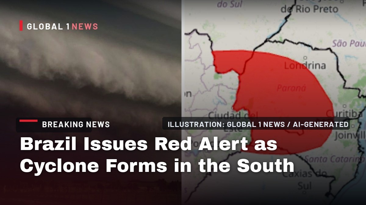
Brazil's National Institute of Meteorology has issued its highest-level storm warning — a red alert, "grande perigo," meaning great danger — for four states, effective from 00:00 Thursday 10 September until 23:59 the same day. The alert covers southern Mato Grosso do Sul, Parana, Santa Catarina and the extreme northwest of Rio Grande do Sul. Forecasters expect rainfall above 100 mm, wind gusts above 100 km/h and hail in those zones, with isolated tornadoes possible in the worst-hit areas.
Brazil Issues Red Alert as Cyclone Forms in the South
Atlanta, Georgia — This is the top of INMET's three-tier scale: yellow means potential danger, orange means danger, red means great danger. And for Thursday, a huge swath of southern Brazil sits under red. The agency names the risks plainly: damage to buildings, interruption of electricity supply, losses to crops, falling trees, flooding, and disruption to road transport. INMET does not rule out extremely intense wind gusts caused by atmospheric microbursts, and says isolated tornadoes are possible in the worst-hit regions. Folks, this is not a routine rain event — and it is arriving in a region still healing from disaster.
What Is Actually Happening in the Atmosphere
INMET blames a "cavado" — an elongated area of low pressure sitting over Brazil's South Region. That trough, combined with north-westerly winds and the South American Low-Level Jet, is intensifying the transport of moisture deep into the interior of the continent. Higher up, an active subtropical jet stream is adding further instability, and areas of wind diffluence — where air currents spread apart at altitude — are stimulating the development of very intense storms. INMET also forecasts a cyclonic circulation forming at low levels over southern Brazil, reinforcing the whole setup.
Meteored meteorologist Ana Maria Pereira Nunes says the low-level jet acts like a conveyor belt carrying water vapour and heat from the Amazon, feeding an intense atmospheric river toward the centre-south of Brazil. That jet is forecast to reach extreme values on Friday, exceeding 100 km/h. Climatempo meteorologists describe the same moisture corridor being pulled south. In plain English: the sky over southern Brazil is being loaded with fuel, and something is about to light it.
The Cyclone Timeline: Thursday, Friday, Saturday
Cyclogenesis — the birth of a cyclone — begins over southern Brazil during Thursday afternoon, expected to result in the formation of a cyclone and then a cold front. The system will be most organised on Friday 11 September. G1 and Climatempo report the extratropical cyclone is expected to organise between Rio Grande do Sul and Santa Catarina on Friday, with pressure at the centre potentially falling below 1,000 hectopascals.
The cyclone is then expected to move out over the Atlantic while the cold front pushes toward the South-East. On Saturday 12 September, the cyclone heads for open ocean; the cold front reaches Mato Grosso do Sul, Sao Paulo and Rio de Janeiro; and a polar air mass moves over the south and starts to reach Mato Grosso do Sul and Sao Paulo. Temperatures will drop significantly across the whole South Region and parts of Sao Paulo and Mato Grosso do Sul. The cold air mass over Argentine Patagonia is intense, but current wind patterns should keep it from reaching Brazil with the same strength and reach seen over the 7 September holiday.
G1 RS reports Friday is the day of greatest attention in Rio Grande do Sul because of the deepening low pressure and the cyclone's formation, with rainfall of 20 to 80 mm. The Serra and the north-east of the state are in the most unstable band.
Where the Danger Is Worst — State by State
Parana is bracing hard. INMET issued an orange alert covering practically the whole state on Wednesday, with rain of 30-60 mm per hour or 50-100 mm per day, winds of 60-100 km/h and hail. The state's Civil Defense issued an alert for Friday 11 September, citing a high risk of falling trees, roof damage, flooding and hail, especially in Paranavai, Umuarama and Querencia do Norte, and said winds could exceed 100 km/h when the cyclone arrives on Friday. Simepar meteorologist Raissa Pimentel says the formation of an extratropical cyclone over Rio Grande do Sul plus a cold front advancing over southern Brazil will create favourable conditions for severe storms in Parana. Climatempo estimates rainfall accumulations in Parana could exceed 300 mm in some places by Friday, especially in the west, south-west, south and centre of the state.
In Rio Grande do Sul, the Civil Defense warns of storms with hail, intense gusts and heavy rain across the northern half of the state; gusts above 90 km/h are forecast for the north-west, north and north-east on Friday. Santa Catarina's Civil Defense reports moderate to high risk of flooding and flash floods, mainly in areas near the Parana border, with storms intensifying on Friday with hail and gusts above 80 km/h. In Sao Paulo, an orange alert covers the extreme south-west, around Teodoro Sampaio, and the far south, including Itaporanga, Itarare, Itapeva and Registro. Almost the whole state has a chance of rain, and the state's Civil Defense warns of flooding, flash floods, falling trees and landslides.
Mato Grosso do Sul is under a red alert for the south-west, with the extreme south — including Paranhos, Amambai, Iguatemi, Mundo Novo, Itaquirai and Navirai — under the highest warning. Central Rio Grande do Sul, including Porto Alegre, Santa Maria and Uruguaiana, sits under a yellow alert, along with the north and part of the east of the state, forecasting up to 50 mm of rain, winds of 40-60 km/h and hail. Rio de Janeiro, Minas Gerais and Goias are also under alert — a potential danger warning for up to 50 mm of rain a day, 40-60 km/h winds and possible hail. INMET also issued a gale warning for winds of 60-100 km/h in areas of Rio Grande do Sul, Santa Catarina, Parana, Mato Grosso do Sul and Mato Grosso.
Hail, Microbursts and the Tornado Question
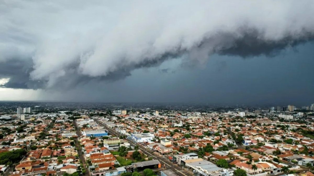
Meteored reports hail risk is high across the entire South Region on Friday, especially in Rio Grande do Sul and western Santa Catarina and Parana. Hail may be large and fall in large quantities, putting people, animals and infrastructure at risk. There is potential for extreme wind events ranging from intense gusts to microbursts or tornadoes. Gusts should exceed 80 km/h on Friday, especially over Parana, with 60-80 km/h gusts across a wide area of Mato Grosso do Sul and Sao Paulo.
Meteored adds that rain associated with repeated intense storms will be extreme between Thursday 10 and Saturday 12, with accumulations that can exceed 100 mm per day. By the end of Sunday, large areas between Santa Catarina, Parana, Sao Paulo, Minas Gerais and Mato Grosso do Sul will have accumulated more than 100 mm, with the biggest volumes between south-west Parana and north-west Santa Catarina exceeding 200 mm — most of it falling between Thursday and Friday. A separate Climatempo alert for southern and western Parana, the extreme south of Mato Grosso do Sul and south-western and southern Sao Paulo state lists tornadoes, hail and wind gusts above 90 km/h from supercell thunderstorms, with the greatest risk on Friday 11 September.
Here is the uncomfortable context: the broader region — southern Brazil, northern Argentina, Uruguay and Paraguay — is one of the world's most active severe-storm corridors, comparable in convective energy to the central United States. Brazil records tornadoes most years, chiefly in Parana, Santa Catarina, Rio Grande do Sul and interior Sao Paulo. This is not foreign weather. It is local weather.
A Region Still Recovering — and Why That Matters
The memory of recent disasters shapes how people here respond to a red alert. In a bulletin issued on 9 August 2026, the Civil Defense of Rio Grande do Sul put the number of people displaced from their homes at 2,686, after an instability line linked to a cold front caused severe storms, with damage recorded in 117 municipalities, including roofs torn off and fallen trees and power poles. One death and five injuries were reported from the storms that began on Friday 7 August, including a motorcyclist killed on state highway RS-124 in Montenegro. The most affected communities included Minas do Leao with 500 displaced, Novo Hamburgo with 480 and Sapiranga with 360.
On 9 September 2026, Brazil's federal government, through the National Secretariat for Protection and Civil Defense, recognised a state of emergency in five municipalities in the South and South-East under Portaria 2.970, published in the Official Gazette. They are Agrolândia in Santa Catarina, from a vendaval on 6 August 2026; Candido de Abreu in Parana, hail on 18 August; Renascença in Parana, hail on 2 September; Irai in Rio Grande do Sul, hail on 31 August; and Lajeado in Rio Grande do Sul, from flooding that began on 22 July 2026, after the town has been repeatedly hit by river floods in recent years.
And then there is May 2024, when Rio Grande do Sul suffered the worst flooding in its history, killing more than 180 people and affecting millions across hundreds of municipalities. That is the backdrop. An extratropical cyclone is a common system in Brazil's centre-south, but forecasters say the combination of heat, humidity and instability in this episode is stronger than usual. Folks, when a state has buried that many neighbours, a red alert is not background noise.
What INMET Says You Should Do Right Now
INMET's own safety guidance is direct. Switch off electrical appliances and the main power switch if necessary. Put documents and valuables in plastic bags in case of flash floods. Seek shelter and avoid staying outdoors in a great-danger situation. In an emergency, call Civil Defense on 199 or the Fire Department on 193.
Beyond that, watch the clock. Thursday is the red-alert day. Friday is the day of greatest attention in Rio Grande do Sul and the day of greatest risk in Parana, according to state authorities. Saturday the system moves offshore but the cold front keeps pushing north and east. If you are in Paranavai, Umuarama, Querencia do Norte, Paranhos, Amambai, Iguatemi, Mundo Novo, Itaquirai, Navirai, Teodoro Sampaio, Itaporanga, Itarare, Itapeva or Registro, you are in a named high-risk zone. Charge your phone, secure anything loose outside, and check on elderly neighbours who live alone.
Do not drive into standing water. Do not shelter under trees. Do not wait for the sky to turn black before you act. And keep your phone on: INMET, Climatempo, Meteored, Simepar and the state Civil Defenses of Parana, Rio Grande do Sul and Santa Catarina are all publishing updates as the cyclone forms. The forecast will change. Your preparation should not.
By Jessica Ali, Staff Writer
This article was produced with AI-assisted research and editorial support. Sources: Instituto Nacional de Meteorologia (INMET), Climatempo, Meteored, Simepar, Defesa Civil do Parana, Defesa Civil do Rio Grande do Sul, Defesa Civil de Santa Catarina, G1, Agencia Brasil, NSC Total, ND Mais, O Globo, UOL Noticias.
What's Your Reaction?
 Like
0
Like
0
 Dislike
0
Dislike
0
 Love
0
Love
0
 Funny
0
Funny
0
 Wow
0
Wow
0
 Sad
0
Sad
0
 Angry
0
Angry
0

Editor-in-Chief at Global1.News. Atlanta-based journalist who cuts through the BS and tells it like it is. Lead anchor, host, and the voice you hear when the spin stops and the truth starts.










Comments (0)