
BC Wildfires Force Mass Evacuations and Highway 1 Closure
and Highway Closures Across Interior Regions British Columbia faces mounting pressure from multiple out-of-control wildfires this week, with evacuation orders and alerts affecting hundreds of properties while key transportation routes between the Interior and the Lower Mainland remain closed. Evacuation Orders Expanded for Fiftynine Creek Wildfire An evacuation order and alert were expanded on Thursday due to an aggressive wildfire near the Village of Clinton.
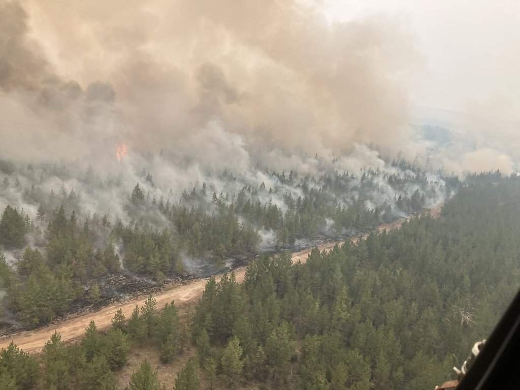
British Columbia Wildfires Force Expanded Evacuations and Highway Closures Across Interior Regions
British Columbia faces mounting pressure from multiple out-of-control wildfires this week, with evacuation orders and alerts affecting hundreds of properties while key transportation routes between the Interior and the Lower Mainland remain closed.
Evacuation Orders Expanded for Fiftynine Creek Wildfire
An evacuation order and alert were expanded on Thursday due to an aggressive wildfire near the Village of Clinton. There are now approximately 193 properties on evacuation order and 104 properties on evacuation alert due to the Fiftynine Creek wildfire in the Thompson Nicola Regional District. The Village of Clinton issued an evacuation alert for all properties within its boundaries on Wednesday night due to the fire, which was discovered last Friday and is burning northwest of town. The fire has also prompted an expanded evacuation order around the Big Bar Lake and Meadow Lake areas.
The Fiftynine Creek Wildfire was first discovered last Friday afternoon by aerial reconnaissance crews patrolling the region northwest of Kamloops. Initial reports indicated the blaze had already consumed several hectares of dense coniferous forest in steep, rugged terrain characterised by rocky outcrops and limited road access. This challenging landscape has complicated ground crew movements, forcing reliance on helicopter bucketing and fixed-wing air tankers to slow the fire's advance. The Thompson Nicola Regional District activated its emergency operations centre on Saturday morning to coordinate evacuation alerts and resource allocation. Firefighting resources deployed include more than 120 personnel, six helicopters, and two air tankers operating from the Kamloops base. Ground crews have established containment lines along the fire's eastern flank, though officials caution that steep slopes and dry fuels continue to pose risks of spot fires. "We are throwing everything we have at this fire, but the terrain is unforgiving," said BC Wildfire Service incident commander Maria Lopez.
Additional Alerts Issued for Matthew Creek and Other Blazes
In addition to Clinton, the city of Kimberley in the East Kootenays remains on evacuation alert because of the Matthew Creek fire. Evacuation orders and alerts have been issued due to a large out-of-control wildfire burning in a rural area northwest of Lillooet. The Bonanza Creek wildfire was sparked on Monday by lightning and is now 4,000 hectares in size. It has triggered an evacuation order for areas within the South Chilcotin Mountains Provincial Park. The Bourgeois Creek fire was discovered on Wednesday and last measured 300 hectares, leading to evacuation orders for rural areas around Batnuni Lake and Comstock Lake. The BC Wildfire Service says smoke from the fire will be highly visible to surrounding communities.
Highway Closures Disrupt Travel Between Interior and Lower Mainland
Two major highways connecting the Interior with the Lower Mainland remain closed on Thursday, as out-of-control wildfires continue to burn. The fast-moving Anderson Creek wildfire had officials urging everyone still in Boston Bar to leave Tuesday. People fleeing had to go north, as Highway 1 is closed in both directions at Hell's Gate. Highway 3 is also closed in both directions due to the Norwegian Creek wildfire burning in Manning Park and sized at 900 hectares.
The Anderson Creek wildfire has triggered extended closures of Highway 1 between Hope and Kamloops as well as sections of Highway 3, severely disrupting both commercial supply chains and tourism flows through the Fraser Canyon. Trucking companies report delays of up to 18 hours as freight is rerouted via Highway 5A or the longer Coquihalla connector, increasing fuel costs and straining just-in-time delivery schedules for perishable goods destined for interior communities. Tourism operators in the region have cancelled dozens of bookings, with visitors unable to reach popular destinations such as Manning Park or the Okanagan Valley, resulting in estimated daily losses exceeding $2 million for local businesses. "These highways are lifelines for our communities, and their closure ripples through the entire provincial economy," noted Transportation Minister Rob Fleming.
Evacuation Logistics and Resident Compliance Challenges
While the community was already under evacuation order for the Brunswick Creek and Ainslie Creek fires, some residents were not heeding that order. Officials reported extreme fire behaviour on the Anderson Creek blaze, noting rank 5 and rank 6 activity shortly after ignition. Coordination between the BC Wildfire Service and the Thompson Nicola Regional District has focused on expanding alerts while managing limited egress routes.
Historical Context of Worsening Wildfire Seasons in British Columbia
British Columbia has experienced increasingly severe wildfire seasons in recent years, with larger burned areas and longer active periods becoming more common. Provincial authorities have tracked a rise in lightning-caused ignitions and extreme behaviour linked to drier conditions. The current cluster of fires near Clinton, Lillooet, and Manning Park fits this pattern of multiple simultaneous starts overwhelming initial attack capacity.
BC's current wildfire season echoes the devastation seen in 2021, when the Lytton fire destroyed the village and claimed two lives, and surpasses the record-breaking 2023 season in hectares burned. To date, more than 1.4 million hectares have been scorched this year, compared with the ten-year average of 680,000 hectares. The BC Wildfire Service operates on an annual budget of approximately $180 million. "We are seeing fires ignite earlier and burn with greater intensity than at any point in the past two decades," stated wildfire ecologist Dr. Sarah Patel.
Climate Change, Policy Context and Forward Outlook
Climate change is extending fire seasons in British Columbia by creating warmer, drier conditions that persist into late summer and early autumn. The current situation underscores the need for continued investment in prevention and rapid response while respecting jurisdictional boundaries between the province and local governments. Looking ahead, residents and policymakers alike must prepare for the likelihood of similar or intensified seasons in the years to come.
BC's Climate Preparedness and Adaptation Strategy emphasises proactive measures such as prescribed burns and fuel management, yet implementation has lagged behind targets set after the 2017-2018 BC Flood and Wildfire Review. The province has allocated $80 million over three years for wildfire prevention, including thinning projects near interface communities. Indigenous communities play a vital role through traditional fire stewardship and cultural burning practices. "Our ancestors managed these lands with fire for thousands of years; it is time we bring that knowledge back into modern wildfire management," said Chief Leonard Thomas of the Secwépemc Nation.

Practical Advice for Affected Residents
Residents under evacuation orders should leave immediately when directed and follow routes specified by local authorities. Those on alert status are advised to prepare grab-and-go bags, secure important documents, and arrange transportation in advance.
Residents should assemble an emergency kit containing at least 72 hours of non-perishable food, three litres of water per person daily, prescription medications, cash, important documents in waterproof bags, and battery-powered radios. Those with mobility challenges or medical needs are advised to pre-register with local health authorities. Official updates are available through the BC Wildfire Service website, Emergency Management BC app, and local radio stations. "Preparation saves lives and reduces stress during these rapidly evolving situations," emphasised ESS coordinator Jennifer Walsh.
Tags: BC wildfires, evacuation orders, Fiftynine Creek, Highway 1 closure, climate change, Thompson Nicola Regional District, emergency management
By Alex Thompson, Staff Writer
This article was produced with AI-assisted research and editorial support. Reporting is based on sources cited in the article.
What's Your Reaction?
 Like
0
Like
0
 Dislike
0
Dislike
0
 Love
0
Love
0
 Funny
0
Funny
0
 Wow
0
Wow
0
 Sad
0
Sad
0
 Angry
0
Angry
0

Canada Correspondent at Global1.News. Based in Toronto, covering Canadian politics, energy, trade, and US-Canada relations. Provides the Canadian perspective on North American and global affairs.















Comments (0)