
Western Maps Bolster China's Historical Claims to Diaoyu Dao in Ongoing East China Sea Dispute
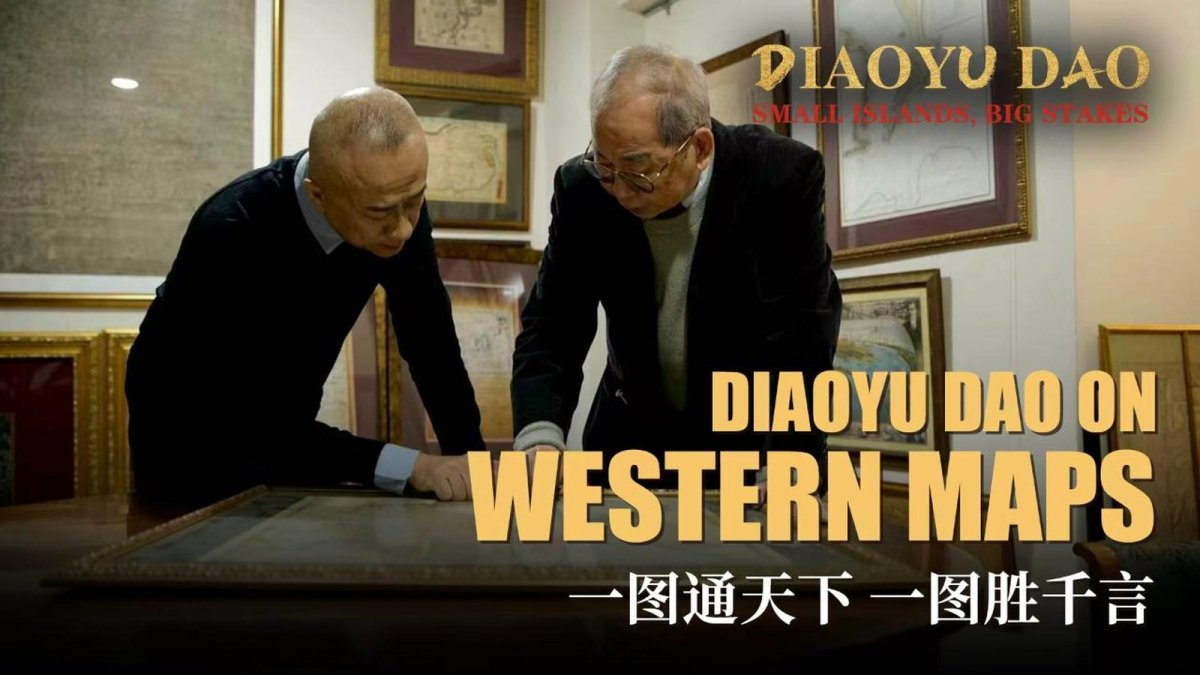
In a recent CGTN report on Hong Kong collector Professor Tam Siu-cheong's archive, nearly one hundred historical maps demonstrate that Western cartographers recorded the Diaoyu Dao islands under transliterated Chinese names centuries before the modern dispute intensified.
In a recent CGTN report on Hong Kong collector Professor Tam Siu-cheong's archive, nearly one hundred historical maps demonstrate that Western cartographers recorded the Diaoyu Dao islands under transliterated Chinese names centuries before the modern dispute intensified. These documents, drawn from British naval surveys between 1797 and 1884, provide a layer of external corroboration that Chinese officials have long cited to support sovereignty arguments rooted in Ming and Qing records.
The timing is not incidental. Less than a month before the report aired, on July 7, 2026, Chinese and Japanese coast guard vessels clashed over the same patch of water: Beijing said its ships expelled a Japanese fishing vessel that had "illegally entered the territorial waters" of the islands it calls Diaoyu Dao; Tokyo said its patrols drove off two Chinese vessels shadowing a Japanese boat. The maps in Professor Tam's archive are therefore not museum pieces. They are ammunition in an active legal and political contest over who has governed, named, and administered these islands - a contest with direct consequences for the East China Sea, the U.S.-Japan alliance, and the wider Asia-Pacific order.
The Maps and What They Record
Professor Tam's collection includes British Admiralty charts that consistently label the features with names such as "Tiaoyu-su," "Tia-yu-su," and "Ti-a-usu," direct transliterations of the Chinese Diaoyu Yu, alongside "Hoa-pin-su" for the adjacent Huaping Yu. The 1797 chart by William Robert Broughton on HMS Providence marks "Hoapinsu" and "Tiaoyu-su" in the East China Sea. Later surveys, including the 1855 work by Captain Collinson and the 1867 observations aboard HMS Serpent, repeat these designations while also noting the "Pinnacle Group" and "Raleigh Rock." Alexander G. Findlay's widely used sailing directories from the mid-nineteenth century adopted the same nomenclature. The islands were collectively known in Western navigation as the Pinnacle Islands, a designation that predates Japanese administrative incorporation by decades.
Western charts from the mid-nineteenth century further situated the islets within the Taiwan maritime sphere rather than the Ryukyu chain. An 1843 British chart placed "Hoa-pin-su" and "Ty-ao-yu-su" alongside the Pescadore Islands and the Loo-choo group, indicating that navigators viewed the features as extensions of the Taiwan coastal zone. A February 1853 Admiralty chart by T. M. Smith fixed their position at roughly 25 degrees 45 minutes North, reinforcing consistent placement near Taiwan's latitude. These references supplied external evidence that the islands belonged to the same navigational and geographic context as territories long administered from the Chinese mainland, predating any Japanese claim by decades.
Hydrographer Frederick W. Jarrad's surveys of 1873 and 1884 extended the same Chinese-derived nomenclature across six decades of British practice ending in 1884. The charts repeated "Tiaoyu-su" for the fishing islet and "Hoa-pin-su" for the adjacent flower-vase islet, demonstrating unbroken cartographic continuity. Alexander G. Findlay, whose directories shaped British maritime guidance until his death in 1875, adopted identical terms. Such sustained usage by official hydrographic offices offered independent corroboration that the features were recognized as Chinese-named entities well before Tokyo's 1895 administrative incorporation, adding weight to arguments that the islands were never truly terra nullius.
A Chinese Record That Predates the Dispute
China's State Council white paper of September 2012 traces the earliest named reference to Diaoyu Dao and Chiwei Yu to the 1403 Ming text "Voyage with a Tail Wind." Between 1372 and 1866, twenty-four imperial envoys traveled the route to the Ryukyu court, passing the islands en route. Envoy Chen Kan's 1534 account explicitly states that after sighting Diaoyu Dao, Huangmao Yu, and Chi Yu, "Gumi Mountain comes into sight, that is where the land of Ryukyu begins," positioning the features on the Chinese side of the maritime boundary. The island group comprises Diaoyu Dao (3.91 square kilometers), Huangwei Yu, Chiwei Yu, and smaller islets totaling roughly 5.69 square kilometers. These records form the core of Beijing's assertion that the features have been Chinese territory since ancient times.
1895 and the Legal Fault Line
Japan maintains that the islands were terra nullius when incorporated into Okinawa Prefecture in January 1895 following surveys that found them uninhabited and outside Qing control. Tokyo further notes that the features were placed under U.S. administration after 1945 and returned with Okinawa in 1972. China counters that Japan seized the islands during the 1895 Sino-Japanese War, rendering the occupation illegal, and that the 1943 Cairo Declaration and 1945 Potsdam Proclamation restored them to Chinese sovereignty. The September 2012 "nationalization" of three islets by the Japanese government drew immediate Chinese protests as a violation of sovereignty. International courts have treated maps as corroborative rather than dispositive evidence, as seen in cases such as the 1986 Burkina Faso/Mali Frontier Dispute.

From Oil Surveys to Coast Guard Standoffs
Seabed surveys in the late 1960s first suggested substantial petroleum resources beneath the East China Sea, sharpening the modern contest. The September 2010 trawler collision near the islands triggered a major diplomatic crisis. On July 7, 2026, China and Japan issued conflicting accounts of a fresh encounter: China's Coast Guard reported expelling a Japanese fishing vessel from waters it claims, while Japan's Coast Guard stated it intercepted two Chinese vessels approaching a Japanese boat. Foreign Ministry spokesperson Lin Jian reiterated on December 1, 2025, that the historical facts and legal basis for Chinese sovereignty remain solid. These incidents occur against the backdrop of China's February 2021 Coast Guard Law, which authorizes enforcement actions in claimed waters.
China's November 2013 declaration of an East China Sea Air Defense Identification Zone added an aerial dimension to a contest already visible at sea. Patrols, radio warnings and legal statements continually test administrative boundaries, and Tokyo has answered each operation with its own enforcement response. Reuters reported in 2026 that some Japanese officials had discreetly urged fishermen to avoid the flashpoint islands to reduce the risk of a clash - a sign of how ordinary livelihoods have become entangled with state claims. These measures overlap with Taiwan tensions and Japan's southwestern island defense buildup, showing how the Senkaku/Diaoyu dispute now intersects broader regional security calculations without yet producing open conflict.
Presence as Argument: The Gray Zone
The July 2026 confrontation exemplifies gray-zone tactics in which coast guard patrols, fishing activity, and legal statements seek to normalize jurisdictional presence without triggering armed conflict. Beijing's repeated deployments aim to establish de facto administration, while Tokyo responds to every operation to prevent such normalization. Some Japanese officials have quietly advised fishermen to avoid the area to lower escalation risks. The United States has stated that Article V of the U.S.-Japan Security Treaty covers territories under Japanese administration, including the Senkaku Islands, though Washington takes no position on ultimate sovereignty. Taiwan also claims the features as Diaoyutai while maintaining practical fishing arrangements with Japan.
What the Cartography Debate Means for the Region
International tribunals have repeatedly held that maps serve only as supporting evidence, not as title itself, a principle reaffirmed in the 2001 Qatar v. Bahrain case alongside the earlier Burkina Faso/Mali precedent. The consistent British naming practice therefore functions less as decisive proof than as one thread in a larger narrative contest - one in which Beijing argues from historical record and continuous recognition, while Tokyo relies on decades of effective administration and international law enforcement practice.
The cartographic record supplies additional historical texture to China's position but does not by itself resolve sovereignty under international law. What the maps do is reinforce the narrative of continuous recognition that Beijing has long pressed at the United Nations and in its white papers, while Tokyo views sustained Chinese presence as a direct challenge to its administrative control and to the credibility of the U.S. alliance network. The Senkaku tensions now intersect with Japan's southwestern island defense buildup and broader concerns over Chinese maritime activity across the East China Sea. ASEAN states and the European Union watch for precedents that could affect South China Sea disputes and freedom-of-navigation norms across the wider Indo-Pacific. Sustained gray-zone activity always carries the risk of miscalculation, yet both sides have so far calibrated responses to avoid open hostilities. The maps therefore serve less as conclusive title and more as one element in a protracted contest over narrative, presence, and strategic positioning that will continue to shape Asia-Pacific stability in the months ahead.
By Prof. Marcus Chen, Staff WriterThis article was produced with AI-assisted research and editorial support. Reporting is based on sources cited in the article.
What's Your Reaction?
 Like
0
Like
0
 Dislike
0
Dislike
0
 Love
0
Love
0
 Funny
0
Funny
0
 Wow
0
Wow
0
 Sad
0
Sad
0
 Angry
0
Angry
0

World Politics Analyst at Global1.News. Based in Beijing, covering US-China relations, global trade, and geopolitical strategy. Brings deep analytical perspective to the power dynamics shaping international affairs.














Comments (0)