
Colombia Earthquake: 7.4 Magnitude Rocks Western Colombia
Folks, if you haven't heard the news yet this morning, I'm going to give it to you straight: a massive 7.4-magnitude earthquake just slammed western Colombia, sending shockwaves across the country and into three neighboring nations.
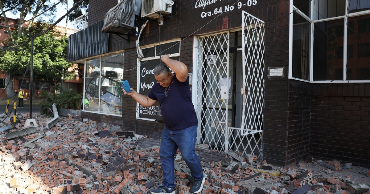
Folks, if you haven't heard the news yet this morning, I'm going to give it to you straight: a massive 7.4-magnitude earthquake just slammed western Colombia, sending shockwaves across the country and into three neighboring nations. This wasn't some distant seismic event you glance at on a map and forget. This one hit close to home — literally for millions of Colombians who felt their buildings sway this morning, and figuratively for all of us who understand that when the ground shifts in the Pacific Ring of Fire, you don't just feel it where the epicenter lands. You feel it everywhere. I've been tracking this since the first USGS alert crossed my screen, working through the data and the official statements, and here's everything you need to know — the facts, the analysis, and what comes next.
Colombia Earthquake: 7.4 Magnitude Rocks Western Colombia
Bogotá, Colombia — August 10, 2026 — A powerful earthquake struck western Colombia at 07:34 a.m. local time on Monday morning, sending people pouring into the streets across the country and triggering emergency protocols from Bogotá to Quibdó. Here's what we know as of right now.
What Happened: The Hard Numbers
Let's cut through the noise and get straight to the seismic facts, because precision matters when the ground moves. The United States Geological Survey has confirmed a magnitude 7.4 earthquake centered approximately 5 kilometers — about 3 miles — east of San José del Palmar in the Chocó Department, on Colombia's Pacific side. That places the epicenter about 240 kilometers, or 150 miles, west of Bogotá, the capital.
Timing: this hit at 07:34 a.m. local time, which is 12:34 UTC — right as millions of Colombians were starting their Monday routines. Schools were opening. Workers were commuting. The USGS measured the depth at 110.3 kilometers, or 68.5 miles. The Colombian Geological Survey also recorded magnitude 7.4, with a slightly shallower depth estimate of 96 kilometers, or about 60 miles. Either measurement tells the same story: this was a deep earthquake. And here's the important part — the energy from a deep quake radiates outward from depth, and the low-frequency waves travel long distances, which is why the shaking carried so far. That's why people felt this in Panama, Ecuador, and Venezuela, hundreds of miles from ground zero.
Where It Hit: Chocó and a Region Already Struggling
This earthquake struck Chocó, and I need you to understand what that means in real terms. Chocó is one of Colombia's poorest departments — a Pacific-side region of dense rainforest and extreme rainfall, where infrastructure challenges are a daily reality even before a disaster strikes. The departmental capital, Quibdó, is now at the center of the damage assessment, and that's a city that simply doesn't have the resilience of a modern financial hub. When the ground shakes here, the consequences are amplified because buildings are older, roads are more fragile, and resources are thinner.
Here's a geographic detail that should grab your attention: the shaking was strongly felt in Colombia's three largest cities — Bogotá to the east, Medellín to the north, and Cali to the south. That means the quake wasn't contained to one population center. This was, quite literally, a three-city event, and that's why the government response is going to have to be massive in scale.
The municipality of Pereira, located in the coffee-growing region on the other side of the Central Andes, also reported injuries and structural damage, according to departmental authorities. That's a significant data point — Pereira is not right next to the epicenter, but the damage there shows just how far this quake's energy traveled through the earth.
The Shaking: A Country and Continent Felt It
Let me paint you the picture of what this morning looked like across the region. In Bogotá, hundreds of people evacuated homes and high-rise buildings almost immediately after the first tremors rolled through the capital. One of the more dramatic moments came when the TransMiCable gondola lift system — a cable car transit network that can carry around 7,000 people per hour — had to be evacuated after the shaking began. Imagine being suspended in a cable car high above the city when the ground starts rolling beneath you. That's not a drill. That's real life, and it's terrifying.
In Medellín, Cali, and Pereira, residents reported strong shaking that sent people into the streets, many of them still in work clothes and slippers, staring up at buildings and waiting for the tremors to stop. Across the borders, the movement was felt in Ecuador to the south, Panama to the north, and Venezuela to the east. This wasn't a localized event — this was a regional event. The fact that a deep earthquake at 7.4 magnitude could rattle countries spanning multiple borders is a reminder of just how interconnected seismic risk is across Latin America. When the Nazca plate grinds against the South American plate, no one in this region gets a free pass.
The Human Toll: Injuries and Significant Damage
Now let's talk about the human cost, because that's what really matters. At the time of this reporting, no official death toll has been confirmed. I want to be clear about that — and I also want to be clear that the absence of a confirmed death toll is not the same thing as saying no one died. Disaster response is still in its early phase, and injury counts are still being compiled. We need to be honest about that reality even as we hope for the best.
What we do know comes from Chocó Governor Nubia Carolina Córdoba, who confirmed that people have been injured — she did not specify how many — and reported "significant damage" to buildings in Quibdó. Governor Córdoba also warned residents to stay alert for possible aftershocks, which is standard but absolutely critical guidance in the hours immediately following a quake of this size.
Pereira also reported injuries and damage, according to departmental authorities. But here's what I want you to understand about the information coming out of Chocó: this is a region where communication and access are already difficult even in good times. Dense rainforest, heavy rainfall, and limited road networks mean that damage assessments in the most remote areas could take days. The early picture we're seeing is likely incomplete — and it's going to become clearer, and possibly more sobering, as emergency teams reach areas that are currently cut off.
The Government Response: Promises and Protocols
Colombia's new President Abelardo de la Espriella — sworn in just three days before this quake, on August 7 — has already weighed in, requesting the installation of a Unified Command Post in San José del Palmar, the municipality at the epicenter, to coordinate the emergency response. The National Unit for Disaster Risk Management, known by its Spanish acronym UNGRD, is also coordinating the effort, and authorities have already begun evaluating the extent of the destruction across the affected areas. The machinery of the state is moving, and moving fast — but the question is whether it can move fast enough for a region as geographically challenging as Chocó.
Here's the thing that worries me, folks: emergency officials have warned of possible aftershocks. That's not alarmism — that's geology. A quake of this magnitude leaves stress in the crust, and the crust readjusts. Aftershocks in the days following a 7.4 event are not just possible; they're expected. The challenge for the government, and for UNGRD, is to keep public attention focused on preparedness while also managing the medium-term recovery. The deep nature of this quake may reduce the likelihood of some of the most severe secondary effects, but the risk is not zero.
President de la Espriella's order is a good sign, but words don't rebuild buildings. The real test will be whether the resources — the search-and-rescue teams, the medical support, the engineering assessments, the food and water supplies — actually reach Chocó quickly. And in a department as difficult to traverse as this one, speed is not guaranteed. I've covered disasters before, and I can tell you: the first 72 hours decide everything.
Why Colombia Shakes: The Tectonic Reality
Let's step back and talk about why this happened, because understanding the forces at work is important. Colombia sits on the Pacific Ring of Fire, the arc of intense seismic and volcanic activity that circles the Pacific Ocean. The reason is subduction: the Nazca plate is being forced beneath the South American plate along the Pacific coast. That process builds enormous pressure over time, and when the pressure releases suddenly, you get earthquakes — sometimes moderate, sometimes catastrophic.
Colombia has history here, and it's not distant history. In 1999, a magnitude 6.2 earthquake struck the city of Armenia, killing around 1,000 people. In 1983, the city of Popayán was devastated by another significant quake. The country knows what seismic violence looks like, and yet — and this is the uncomfortable truth — the gap between the regions that suffer most and the cities that can respond means that the same magnitude event can have wildly different outcomes depending on where it lands. A 7.4 quake under Bogotá would be a different story than a 7.4 quake under Chocó. Not because the ground behaves differently, but because the buildings do.
What It Means: Regional Seismic Activity in 2026
Here's where I'm going to give you some sharp analysis, and you can take it to the bank. Colombia is not an isolated incident. On July 17, 2026 — less than a month ago — a 7.3 magnitude earthquake struck off the Pacific coast of southern Mexico near the Guatemala border, prompting localized tsunami warnings. That's two major Latin American earthquakes in under four weeks. The Ring of Fire is awake, folks, and 2026 is shaping up to be a year that tests the region's disaster preparedness in ways we haven't seen in recent memory.
What does this mean for Colombia specifically? It means Chocó's infrastructure challenges are now front and center on a national stage. This is one of the poorest regions in the country, with high rainfall, dense rainforest, and limited connectivity. The reconstruction effort here is going to be measured in years, not weeks. And the broader lesson for the region is simple: seismic activity on this scale doesn't follow a calendar. It doesn't announce itself. All we can do is build better, prepare better, and respond faster. That's not a slogan — that's survival.
What You Can Do: From Awareness to Action
Look, I'm not one to sit in a studio and wring my hands. If you're as fired up as I am about helping the people of Chocó, here's what you can actually do right now. First, if you're in a position to donate, send money to recognized aid organizations that are operating in Colombia — established groups with local partners on the ground. Avoid the urge to send physical goods to the region; transportation is the bottleneck in Chocó, and cash allows relief agencies to buy what's needed locally, supporting the local economy in the process.
Second, stay informed. The USGS continues to monitor the region, and the Colombian Geological Survey is your best source for local seismic data. Aftershocks are possible, and if you or someone you love is in the affected area, know your evacuation routes and drop-cover-hold-on protocols. If an earthquake starts, drop to the ground, take cover under something sturdy, and hold on until the shaking stops. That's not an oversimplification — that's training that saves lives.
And third, keep your attention on this story. Disasters like this don't end when the news cycle moves on. The recovery in Chocó is going to take years, and sustained attention is what keeps resources flowing and governments accountable. Donate what you can. Make your voice heard. But above all, don't look away.
That's the story from here. The ground moved in Colombia this morning, and the aftershocks — both geological and political — are going to be felt for a long time. We'll be watching, and we'll keep bringing you the facts as they emerge. Stay safe, stay informed, and remember: in a region that shakes, preparation is not an option. It's a necessity.
By Jessica Ali, Staff Writer
This article was produced with AI-assisted research and editorial support. Sources: Reuters, BBC, DW, NYT, CBS News, USGS, AP.
What's Your Reaction?
 Like
0
Like
0
 Dislike
0
Dislike
0
 Love
0
Love
0
 Funny
0
Funny
0
 Wow
0
Wow
0
 Sad
0
Sad
0
 Angry
0
Angry
0

Editor-in-Chief at Global1.News. Atlanta-based journalist who cuts through the BS and tells it like it is. Lead anchor, host, and the voice you hear when the spin stops and the truth starts.











Comments (0)