
Canada's New Tornado Warning System Targets Alert Fatigue
In a recent CBC News report, Environment and Climate Change Canada (ECCC) unveiled a significant overhaul of how tornado and severe thunderstorm warnings reach Canadians. The new Convective Alert Modernization (CAM) system, which took effect on Tuesday, replaces broad, pre-determined warning zones with precise, free-form polygons that target only the areas most likely to be affected by extreme weather. Canada's New Tornado Warning System Aims to End Alert Fatigue with Precisi
In a recent CBC News report, Environment and Climate Change Canada (ECCC) unveiled a significant overhaul of how tornado and severe thunderstorm warnings reach Canadians. The new Convective Alert Modernization (CAM) system, which took effect on Tuesday, replaces broad, pre-determined warning zones with precise, free-form polygons that target only the areas most likely to be affected by extreme weather.
Canada's New Tornado Warning System Aims to End Alert Fatigue with Precision Targeting
Ottawa, Ont. – August 2026 — The days of receiving a tornado warning for a storm 200 kilometres away are coming to an end. Environment and Climate Change Canada officially launched its Convective Alert Modernization (CAM) system this week, a change that allows forecasters to draw custom polygons around the exact areas where severe thunderstorms and tornadoes are expected to strike. The system, confirmed operational on Tuesday with an official launch planned for Wednesday, represents the most significant update to Canada's severe weather alert infrastructure in decades.
The Story: How the New System Works
Under the CAM system, ECCC forecasters no longer issue warnings for large, pre-determined alert zones that can stretch across several hundred kilometres. Instead, they use free-form polygons to define the warning area based on the storm's projected path. The narrow end of the polygon indicates the current focus of concern, while the polygon widens downstream to reflect uncertainty in the storm's exact trajectory. This approach, already used in the United States since 2007, allows for dramatically more precise alerts.
When a warning is issued, cellphones within the polygon receive emergency text notifications through the National Public Alerting System (Alert Ready). The alerts include a list of up to 10 locations ordered by projected time of arrival, along with the main weather hazards — wind, hail, heavy rain — and safety information. Giselle Dookhie, warning preparedness meteorologist at ECCC, explained that the system "will provide a list of locations in nearby areas that could be impacted, and that list will be ordered by time of arrival and display up to 10 different locations" while still containing "all of the relevant information in terms of what the main weather hazards are."
It's important to note that the polygons will not be visible on mobile apps like WeatherCAN. The targeted warnings are delivered exclusively through the Alert Ready system, meaning radio and television alerts will still use the older broadcast-region system because broadcast regions are large. ECCC's alert map will feature multiple layers for warnings and watches, capable of showing overlapping alerts as storms develop.
Why the Old System Fell Short
The previous system relied on zone-based warnings, which often meant that residents in a major city like Edmonton or Winnipeg would receive a tornado warning for a storm that was actually threatening a sparsely populated rural area hundreds of kilometres away. This over-warning contributed to what meteorologists call "alert fatigue" — a dangerous desensitization where Canadians begin to ignore the very alerts designed to save their lives.
Jonathan Bau, senior meteorologist at ECCC, acknowledged the problem directly. "What this means is that when we're issuing one of those two warnings, the alert goes out to a larger number of people than perhaps what the immediate danger really represents," he said. "The change to freeform polygons is to reduce the amount of over-alerting."
David Sills, director of the Northern Tornadoes Project at Western University in London, Ont., has been advocating for this change for years. "It's great that Environment Canada is finally able to implement this," Sills said. "The idea is that instead of warning for a county or some other municipal boundary that's typically large in certain parts of Canada, you're warning based on the meteorology, based on where the storm is actually going to affect." Sills pointed to the American experience, where polygon-based warnings have cut down on false alarms since their introduction in 2007.
Canadian Context: A Summer of Severe Weather
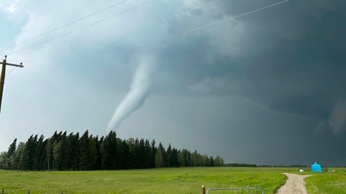
The timing of this system's launch is no coincidence. Canada has experienced an exceptionally active severe weather season in 2026. Record tornado activity on the Prairies earlier in the season captured national attention, and tornadoes in Alberta sent three people to hospital at Dillberry Lake. On July 18, a tornado caused significant damage in parts of west-central Alberta, a reminder of the destructive power these storms can unleash.
This summer has also seen red tornado warnings issued for parts of northwestern Ontario, including the Kenora, Sioux Narrows, Dryden and Vermilion Bay areas, as a severe thunderstorm that Environment Canada said was possibly producing a tornado travelled eastward. These events underscore the need for a system that can differentiate between a storm threatening a populated centre and one that will pass through uninhabited bushland.
For Canadians living in tornado-prone regions — from Windsor to Regina to Red Deer — the new system represents a meaningful improvement in public safety infrastructure. The federal government's investment in CAM reflects a broader commitment to modernizing emergency alert systems, a priority that has gained urgency as climate change increases the frequency and intensity of severe weather events across the country.
Impact on Canadians: Fewer Alerts, Better Protection
The practical impact for Canadians is straightforward: fewer alerts on their phones, but alerts that carry more weight. Dookhie emphasized that this is the core goal. "Alert fatigue is something that we know everyone has. It's not something we want the public (to take lightly) when they see a warning for a severe thunderstorm or tornado warning," she said. "We want them to know that it's likely to impact them, and they should protect themselves and others and their property from harm."
Gordon Howard, Kenora, Ont.'s director of emergency services, understands the balancing act well. "One of the biggest challenges with any emergency notification system is maintaining public trust," Howard said. "If alerts are issued too frequently or for situations that don't ultimately pose a significant risk, people can become desensitized and may be less likely to take future warnings seriously."
Howard also acknowledged the inherent tension in emergency management. "At the same time, emergency services are naturally inclined to err on the side of caution. That means there will be occasions when alerts are issued for situations that ultimately do not develop into a significant emergency. It's a balancing act we face with any emergency notification system, we have to weigh the risk of over alerting against the potentially greater risk of not providing people with enough warning to take protective action."
The new system does not eliminate that tension, but it narrows the gap between the warning area and the actual danger zone. Sills offered a concrete example: "There are all kinds of examples of storms where people in a big city got a tornado warning, for instance, but the tornado was actually in a more unpopulated area of a larger region, and the city really wasn't going to be affected at all. In that kind of case, it's going to be the people that are directly affected that will get the warning."
Reactions and Analysis: A Long-Awaited Modernization
The reaction from the meteorological community has been overwhelmingly positive, though tempered with practical concerns about the transition period. Dookhie acknowledged that migration to the new system will take time. "It's going to take some learning with the system, because not everyone is going to be able to migrate at the same time, to displaying the polygon warnings," she said. "So Environment Canada is making both zone-based warnings on polygon warning data available."
This dual-track approach means that during the transition, some Canadians may still receive zone-based alerts while others receive polygon-based alerts, depending on the specific warning and the systems in place at local broadcasters and emergency management offices. ECCC's alert map will display both types of warnings, with layers that can show overlapping alerts as the situation evolves.
The decision to limit targeted alerts to severe thunderstorm and tornado warnings is deliberate. All other weather alerts — heat warnings, thunderstorm watches, and the like — will continue to be issued to pre-determined zone-based areas. This reflects the unique, fast-moving nature of convective storms, which require a more nimble alerting approach than slower-developing weather events like heat waves or winter storms.
For Canadians who have grown accustomed to ignoring emergency alerts, the change represents an opportunity to rebuild trust in the system. The federal government, through ECCC, is betting that fewer, more accurate alerts will lead to better public response when it matters most. The stakes are high: in a country where tornadoes can strike with little warning, the difference between a targeted alert and a broad one can be measured in lives saved.

What Happens Next: Implementation and Adaptation
As the CAM system becomes fully operational over the coming weeks, ECCC will monitor its performance and gather feedback from emergency managers, broadcasters, and the public. The transition period will be critical for identifying any technical issues with the polygon-based alerts and ensuring that all Canadians receive warnings in a timely manner.
For municipalities like Kenora, which has already dealt with tornado warnings this summer, the new system offers a more precise tool for protecting residents. Howard's comments reflect a broader recognition that emergency notification is as much about public psychology as it is about technology. The goal is not just to send alerts, but to ensure that when an alert arrives, Canadians take it seriously.
The CAM system also raises questions about the future of weather alerting in Canada. As climate change continues to intensify severe weather events, the demand for precise, actionable warnings will only grow. The polygon approach, while a significant step forward, may eventually be complemented by even more granular alerting technologies, such as location-based alerts that follow individual cellphones rather than geographic areas.
For now, Canadians can expect a noticeable change in their alert experience. The days of receiving a tornado warning for a storm that will never come near them are numbered. In their place, a more precise, more trustworthy system is taking root — one that promises to cut through the noise and deliver the information Canadians need, when they need it most.
The launch of the CAM system this week marks a pivotal moment for public safety in Canada. It reflects a commitment to evidence-based meteorology, a recognition of the psychological realities of alert fatigue, and a determination to use technology to protect Canadians more effectively. As the 2026 severe weather season continues, the new system will face its first real-world tests. The meteorological community, from ECCC forecasters to researchers at Western University's Northern Tornadoes Project, will be watching closely.
By Alex Thompson, Staff Writer
This article was produced with AI-assisted research and editorial support. Reporting is based on sources cited in the article.
What's Your Reaction?
 Like
0
Like
0
 Dislike
0
Dislike
0
 Love
0
Love
0
 Funny
0
Funny
0
 Wow
0
Wow
0
 Sad
0
Sad
0
 Angry
0
Angry
0
Canada Correspondent at Global1.News. Based in Toronto, covering Canadian politics, energy, trade, and US-Canada relations. Provides the Canadian perspective on North American and global affairs.













Comments (0)