
Thailand Warns 15 Provinces of Landslides and Flash Floods
Heavy monsoon rains across Thailand have prompted the Department of Mineral Resources to issue landslide and flash flood warnings for 15 provinces, urging residents in vulnerable areas to remain vigilant over the coming days. The warning, announced on Thursday by the department's Geological Disaster Operations Centre, comes as seasonal downpours continue to saturate hillsides and low-lying communities from the northern highlands to the southern coastline.
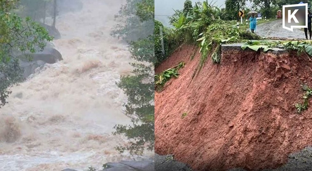
Heavy monsoon rains across Thailand have prompted the Department of Mineral Resources to issue landslide and flash flood warnings for 15 provinces, urging residents in vulnerable areas to remain vigilant over the coming days. The warning, announced on Thursday by the department's Geological Disaster Operations Centre, comes as seasonal downpours continue to saturate hillsides and low-lying communities from the northern highlands to the southern coastline.
The affected provinces span multiple regions, including Nan, Phrae, Uttaradit, Tak, Kamphaeng Phet, Phetchabun, Loei, Nong Khai, Bueng Kan, Sakon Nakhon, Nakhon Phanom, Mukdahan, Amnat Charoen, Ubon Ratchathani, and Yasothon. These areas are considered high-risk zones where the combination of prolonged rainfall and already waterlogged soil increases the probability of ground movement and flash flooding.
Monsoon Intensity and the Science Behind the Warning
Thailand's annual monsoon season typically runs from late May through October, but July and August are historically the peak months for landslide-related incidents. The Department of Mineral Resources monitors real-time rainfall data, soil moisture levels, and geological susceptibility maps to issue these alerts. According to the department's Geological Disaster Operations Centre, the current weather pattern involves a strong monsoon trough extending across northern and northeastern Thailand, interacting with a low-pressure system over the South China Sea.
This convergence has produced sustained rainfall exceeding 100 millimetres in some areas over a 24-hour period — a threshold that significantly raises landslide risk on slopes steeper than 15 degrees. The department's disaster monitoring network, which includes over 20,000 trained village volunteers across the country, has been activated to track ground conditions and relay warnings to local communities.
Provinces at Highest Risk
Among the 15 provinces under warning, several face particularly elevated danger due to their topography and recent rainfall patterns. Nan province in the upper north, with its mountainous terrain and narrow river valleys, has historically experienced some of Thailand's deadliest landslides. In 2024, a landslide in Nan's Thung Chang district destroyed several homes and forced the evacuation of over 200 families.
Ubon Ratchathani in the northeast, Thailand's second-largest province by area, is at risk of both landslides in its western highlands and flash flooding across its low-lying plains near the Mun River. The province is also home to the Pha Taem National Park, where steep sandstone cliffs are prone to collapse during heavy rain. In the northern reaches, Loei and Nong Khai face similar dual threats, while Bueng Kan and Nakhon Phanom lie along the Mekong River, where rising water levels compound the danger.
Community Response and Volunteer Networks
What sets Thailand's disaster preparedness apart from many of its neighbours is the extensive network of community-based disaster monitoring volunteers. The Department of Mineral Resources has trained local residents in each at-risk village to recognise early warning signs: cracks appearing on slopes, tilting trees, sudden changes in stream water volume or colour, and unusual sounds from hillsides. These volunteers serve as the first line of defence, often detecting danger before official instruments can confirm it.
In Ban Pha Khap, a village in Phrae province that survived a major landslide in 2022, village headman Somchai Wongwiset told local media that his team had already begun round-the-clock monitoring. "We know the sound of the mountain when it is angry," he said. "After three days of continuous rain, we sleep in shifts now." The department's warning system has been credited with reducing landslide fatalities in Thailand by more than 60 percent over the past decade, from an average of 85 deaths per year in the 2010s to approximately 30 in recent years.
Economic and Agricultural Implications for Rural Thailand
The 15 provinces under warning are predominantly agricultural, producing a significant portion of Thailand's rice, cassava, rubber, and fruit crops. The northeast region, or Isaan, accounts for nearly half of the country's rice production, and flash floods during the growing season can devastate entire harvests. Farmers in Yasothon and Amnat Charoen have already begun emergency harvesting of early-maturing rice varieties, hoping to salvage what they can before the worst of the rains arrive.
The timing is particularly challenging. July is the peak planting season for the main rice crop under Thailand's rain-fed agricultural calendar. Flooding at this stage not only destroys seedlings but also delays replanting, potentially pushing harvests past the October window and into the cooler months when yields decline. For smallholder farmers who depend on a single annual harvest, the loss can mean a full year without income. The Ministry of Agriculture and Cooperatives has yet to announce emergency relief measures for the current weather event, but local agricultural extension offices in several provinces have been instructed to assess damage reports in real time.
Urban and Infrastructure Concerns
While rural communities face the most direct danger from landslides, the warnings also carry implications for Thailand's transportation infrastructure. Several key highways pass through the affected provinces, including Highway 12 through Phitsanulok and Phetchabun, and Highway 21 connecting Saraburi to Loei — both critical arteries for freight transport between central Thailand and the north. Landslides have blocked sections of these roads in previous monsoon seasons, causing multi-day detours that increase transport costs by as much as 30 percent for affected routes.
The State Railway of Thailand has also been placed on alert for sections of the northeastern rail line that run through hilly terrain in Nakhon Ratchasima and Khon Kaen provinces. While the current warning zone does not include these provinces directly, the interconnected nature of Thailand's transport network means that disruptions in one region can ripple across the entire system. For tourists travelling to popular northern destinations such as Chiang Mai and Pai, the warnings serve as a reminder to check road conditions before departing and to avoid travel on mountain roads during and immediately after heavy rainfall.
The Role of Climate Change in Thailand's Extreme Weather
Thailand has experienced a marked increase in extreme rainfall events over the past two decades, consistent with global climate projections for Southeast Asia. The Intergovernmental Panel on Climate Change has identified the region as one of the most vulnerable to climate-induced changes in hydrology, with models projecting a 10 to 20 percent increase in monsoon rainfall intensity by mid-century. Thailand's Department of Mineral Resources has already documented a 35 percent increase in landslide-triggering rainfall events since 2015, a trend that underscores the urgency of expanding early warning systems and investing in long-term mitigation measures such as reforestation of degraded slopes and improved drainage infrastructure.
Buddhist teachings on impermanence and the cycles of nature resonate deeply with Thai communities facing these recurring threats. In villages across the affected provinces, monks have begun leading prayers for safety, and temples have opened their grounds as potential evacuation shelters. This fusion of scientific early warning systems with community faith networks reflects Thailand's unique approach to disaster resilience — one that respects traditional knowledge while embracing modern monitoring technology.
Looking Ahead
The Department of Mineral Resources has stated that the current warning will remain in effect for the next one to three days, subject to revision as weather patterns evolve. Residents in the 15 provinces are advised to monitor updates from the department's official channels and to contact local disaster prevention offices if they observe signs of ground movement or rising water levels. For readers in Bangkok and other unaffected areas, the situation serves as a reminder of Thailand's vulnerability during the monsoon months and the importance of supporting disaster preparedness efforts in at-risk communities.
By Ann Srisawat, Staff Writer
This article was produced with AI-assisted research and editorial support. Reporting is based on sources cited in the article.
What's Your Reaction?
 Like
0
Like
0
 Dislike
0
Dislike
0
 Love
0
Love
0
 Funny
0
Funny
0
 Wow
0
Wow
0
 Sad
0
Sad
0
 Angry
0
Angry
0

Southeast Asia Correspondent at Global1.News. Based in Bangkok, covering Thai and Southeast Asian politics, economy, technology, and culture. Deep regional perspective on one of the world's most dynamic regions.















Comments (0)