
Himalayan Glacier Collapse Floods Nepal: Andean Warning
The thunder that tore through the Langtang Valley on the morning of August 26, 2026, was not the rumble of an earthquake, but the sound of a mountain coming apart. A colossal section of a Himalayan glacier, weakened by decades of warming, broke free and plunged nearly 1,200 metres, unleashing a wall of ice, rock, and water that obliterated everything in its path along the Nepal-Tibet border.
The thunder that tore through the Langtang Valley on the morning of August 26, 2026, was not the rumble of an earthquake, but the sound of a mountain coming apart. A colossal section of a Himalayan glacier, weakened by decades of warming, broke free and plunged nearly 1,200 metres, unleashing a wall of ice, rock, and water that obliterated everything in its path along the Nepal-Tibet border. As the death toll climbs past 360 and nearly 1,500 people remain missing, scientists and disaster managers are looking not just at the shattered communities of the Hindu Kush Himalaya, but across the globe to the Andes, where the same deadly recipe of melting ice and swelling lakes threatens cities like Huaraz, Peru.
Himalayan Glacier Collapse Unleashes Catastrophic Floods — and a Warning for the Andes
Kathmandu, Nepal – August 27, 2026 — The catastrophic flash floods that swept through Nepal's Rasuwa district on Wednesday morning have left more than 360 people confirmed dead, with nearly 1,500 missing across Nepal and Tibet, in what experts are calling one of the most devastating glacial disaster events of the decade. The trigger was not a torrential monsoon downpour, but the sudden, violent collapse of a glacier high in the Himalayas near Langtang Lirung peak in Langtang National Park, a stark reminder that the world's frozen regions are becoming increasingly unstable. For Latin America, where the Andes are melting at an alarming rate, the event is a terrifying preview of a potential future, as glacial lakes above populated cities grow dangerously full.
The Day the Mountain Broke — A Glacier's Deadly Fall
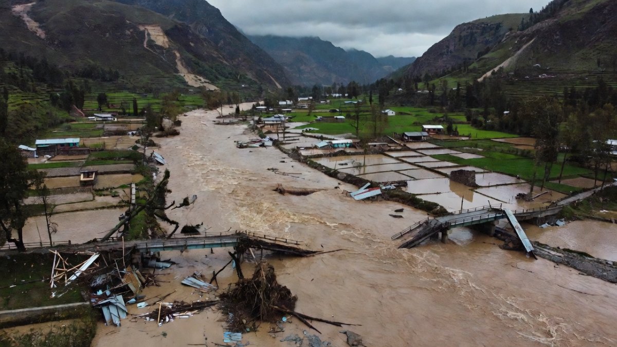
The disaster began at approximately 8:40 am local time (02:55 GMT) on Wednesday, August 26, 2026, when satellite imagery confirmed that a substantial section of the lower end of a glacier broke away at an elevation of about 5,200 metres (17,000 ft). The massive block of ice plunged roughly 1,200 metres (3,900 ft) to the valley floor, gathering immense amounts of rock and sediment as it thundered downward. The ice-rock avalanche struck the Lhende Khola river in Tibet, about 20 km (12 miles) northeast of the Nepal-China border crossing, creating a natural dam of debris that temporarily blocked the river's flow. Within a short period, the unstable dam gave way, releasing a powerful and catastrophic flood surge downstream that would devastate everything in its path.
Initial reports from the region blamed a magnitude 4.4 earthquake for the sudden flooding, but a detailed analysis by the USGS (US Geological Survey) of long-period seismic waves revealed a different, more alarming truth. The tremor, which registered as a magnitude 5.2 seismic event on the Surface-wave magnitude scale, was consistent with a glacier collapse, not an earthquake. Germany's GFZ Helmholtz Centre also recorded a 4.4 tremor that was not consistent with tectonic activity, corroborating the USGS findings. The flood surge entered the Lhende Khola, feeding into the Bhote Koshi and then the Trishuli River, carrying floodwaters south through Nepal. According to experts at ICIMOD (International Centre for Integrated Mountain Development) in Kathmandu, water levels in the Trishuli River rose by as much as 9 metres (27 ft) in just 30 minutes, a terrifyingly rapid rise that left no time for effective evacuation.
A Flood Without Rain — Why the Warning Never Came
Perhaps the most chilling aspect of this disaster is that the weather was perfectly clear. It was not raining, and officials were caught completely off-guard by what they described as "a flood without rain." The debris and water travelled at an astonishing speed of around 50 m/s (160 ft/s), meaning that even if warnings had been issued, there would have been little to no time for residents and tourists to reach higher ground. The sheer velocity of the surge transformed the Trishuli River from a calm mountain stream into a raging torrent of mud, boulders, and ice within minutes, sweeping away bridges, roads, and entire buildings with ease.
In the aftermath, Chinese authorities issued urgent warnings of a new, secondary threat: a barrier lake had formed upstream in Gyirong containing an estimated 2,000,000 cubic metres of water, with a high risk of breaching. They projected an expected inflow of 3,000,000 cubic metres until August 30, raising the spectre of further flooding downstream. Satellite observations taken before the collapse showed unusually warm conditions around the affected glacier, with snow cover diminishing and more bare ice exposed, suggesting that the glacier was already in a fragile state. Scientists are still investigating the precise trigger, but the combination of warm temperatures and exposed ice likely contributed to the structural failure that caused the lower section of the glacier to detach and fall.
The Human Toll — Pilgrims, Workers and Villagers in the Path
The human cost of this disaster is staggering. Nepal's police have confirmed more than 360 people dead, with at least 3 more fatalities reported in Tibet. Across both sides of the border, nearly 1,500 people remain missing. In Nepal alone, 826 people are unaccounted for, including almost 600 foreign tourists. Police and tourism officials report that 668 tourists from 34 countries are missing, including 178 Indians, 65 Americans, 53 Ukrainians, 51 Malaysians, 35 Australians, 33 Britons, and 24 Canadians. Many of these individuals were pilgrims travelling towards the sacred Mount Kailash (Kailash Mansarovar), a journey that took them directly through the flood zone. In Tibet's Gyirong County, Chinese state broadcaster CCTV reported 558 missing, including 260 foreign nationals.
The testimonies from survivors paint a harrowing picture of sudden, violent destruction. Raju Bhadel, a local businessman, told Al Jazeera that his brother-in-law's liquor store and entire house were swept away in an instant. Manoj Mishra, a teacher, described seeing around nine trucks being swept away with people still inside them, helpless against the force of the water. At least 65 people have been treated for injuries in local hospitals and in Kathmandu, with dozens airlifted to the capital for advanced medical care. The Nepalese government has mobilised more than 5,000 army and police personnel, with over 9,000 security personnel deployed, including 4,200 from the army. So far, 351 people have been rescued by helicopter. Nepal has declared the area a disaster-hit zone for three months, and Prime Minister Balendra Shah (Balen Shah) arrived in Nuwakot on August 27 to oversee relief operations.
Warming Skies Over the Himalayas
This catastrophic event is not an isolated anomaly but a stark indicator of the accelerating climate crisis unfolding across the Hindu Kush Himalaya range, which spans Afghanistan, Bangladesh, Bhutan, China, India, Myanmar, Nepal, and Pakistan. According to recent scientific assessments, glaciers across this vast region lost ice 65 percent faster between 2011 and 2020 than during the previous decade. Nepal's glaciers have been particularly hard hit, losing close to one-third of their ice volume in roughly three decades. The rapid retreat is fundamentally altering the landscape, creating unstable slopes and allowing meltwater to accumulate in new, potentially dangerous glacial lakes.
While scientists are still investigating whether climate change directly triggered this specific collapse, the conditions observed before the event are consistent with a warming world. Satellite data showed unusually warm conditions around the affected glacier, with snow cover diminishing and more bare ice exposed, making the glacier more susceptible to structural failure. Researchers are examining whether melting contributed to the glacier's instability, potentially by lubricating the base of the ice or by creating internal fractures. As glaciers retreat, mountain slopes become unstable and meltwater accumulates, increasing the potential for sudden floods. The disaster serves as a grim reminder that the cryosphere is changing rapidly, and the risks associated with these changes are becoming a present-day reality, not a distant future threat.
Andes on Alert — The Warning from Palcacocha
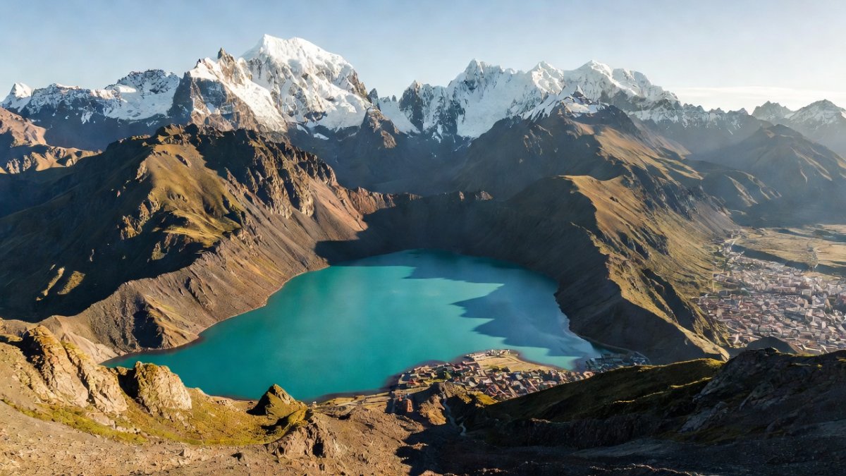
For Latin America, the Himalayan disaster is a direct and urgent warning. Peru has lost more than 42 percent of its glacier surface over the past sixty years — about 700 square kilometres of ice — according to INAIGEM, Peru's national institute for glacier and mountain-ecosystem research. The Cordillera Blanca range in Ancash holds the world's highest concentration of tropical glaciers, and it is here that the threat of a glacial lake outburst flood (GLOF) is most acute. The city of Huaraz, with a population of around 120,000 people, sits directly below Lake Palcacocha, a glacial lake that has grown 34 times larger over the past four decades as its feeding glaciers melt. The lake is penned behind unstable walls of rock and debris, the exact recipe for a GLOF.
Peru has a tragic history with this phenomenon. On 13 December 1941, an outburst from Lake Palcacocha killed roughly 1,800 people — about a third of the city's population at the time, with some estimates even higher. Today, Palcacocha threatens an estimated 3,980 homes or 27,407 inhabitants in the Huaraz and Independencia districts. INAIGEM says three lagoons threaten the city. In response, INAIGEM opened a national monitoring centre in May 2026 to watch high-risk lakes such as Palcacocha in real time. The Palcacocha early warning system (SAT) was built between 2019 and 2021 by the Regional Government of Ancash with an investment of 4.7 million soles, and in May 2026 the regional government took over its operation and maintenance after earlier inspections found deficiencies. Engineers are also monitoring a siphoning project that lowers the lake level to reduce the risk of a catastrophic breach.
What This Means for Latin America — The Race Between Melt and Adaptation
The parallels between the Himalayas and the Andes are impossible to ignore. Research documents at least 160 glacial lake outburst floods across the Tropical Andes since the Little Ice Age, in Peru and Bolivia, demonstrating that this is a recurring and deadly threat. During El Nino Costero coastal warming events off Peru and Ecuador, Andean glacier retreat runs up to three times faster than in a normal year. The warming makes precipitation fall as rain instead of snow, eroding ice instead of rebuilding it, and deposits soot and black carbon that darkens the ice so it absorbs more heat. Regions with the heaviest losses include Ancash and Cusco, with Apurimac having lost 91 percent and Huancavelica 99 percent of its glacier surface.
The implications extend far beyond the immediate risk of flooding. Glacier melt feeds rivers and streams that supply drinking water, farms, and ecosystems across the Andes. As glaciers retreat, they shrink the dry-season water available to Andean communities, creating a long-term water security crisis that will affect millions of people. Experts note that while the Himalayas pose more significant flood risks overall, Huaraz's large population makes the threat to life in the Andes region in some ways even greater. However, there is hope. Bhutan's GLOF experiences in 2019 and 2023 show that local knowledge can improve early warnings, as documented in the International Journal of Disaster Risk Reduction in 2026. The key is investing in monitoring, early warning systems, and community preparedness before the next disaster strikes.
The Bottom Line — Monitoring Is the Difference Between Warning and Tragedy
The catastrophic floods in Nepal are a brutal reminder that the cryosphere crisis is a shared global challenge. The Himalayas and the Andes are both sentinels of climate change, and the disasters unfolding in one mountain range are a rehearsal for what could happen in the other. The difference between a warning and a tragedy lies in the strength of monitoring systems and the speed of response. Nepal's rivers rose 9 metres in 30 minutes; Huaraz's lake is growing larger every year. The investment in early warning systems, like the SAT at Palcacocha and the new INAIGEM monitoring centre, is not an expense but a lifeline.
For Latin American readers, the message is clear: the tragedy in the Himalayas is not a distant event but a mirror of a potential future. The glaciers of the Andes are melting at an alarming rate, and the lakes they feed are swelling behind unstable moraines. The 1941 disaster at Palcacocha killed 1,800 people; today, the city below is far larger, and the lake is 34 times bigger. The technology to monitor these threats exists, and the knowledge to respond is available. What is needed is the political will and the financial commitment to act before the next mountain breaks. The people of Nepal did not have the luxury of a warning; the people of Huaraz still have time, but that time is running out as fast as the ice is melting.
By Elena Vasquez, Staff Writer
This article was produced with AI-assisted research and editorial support. Reporting is based on sources cited in the article.
What's Your Reaction?
 Like
0
Like
0
 Dislike
0
Dislike
0
 Love
0
Love
0
 Funny
0
Funny
0
 Wow
0
Wow
0
 Sad
0
Sad
0
 Angry
0
Angry
0

Latin America Correspondent at Global1.News. Based in Mexico City, covering politics, economics, energy, and culture across the region. Brings an on-the-ground perspective to stories spanning from the Rio Grande to Patagonia.















Comments (0)