
After the Flood, Can China, Nepal, and India Move From Earth Observation to Regional Preparedness?
In the wake of the August 26, 2026 Bhotekoshi‑Trishuli flood—described in the field as a “mountain tsunami”—the imperative to translate Earth observation of the Hindu Kush Himalaya (HKH) into concrete regional preparedness has become starkly evident.
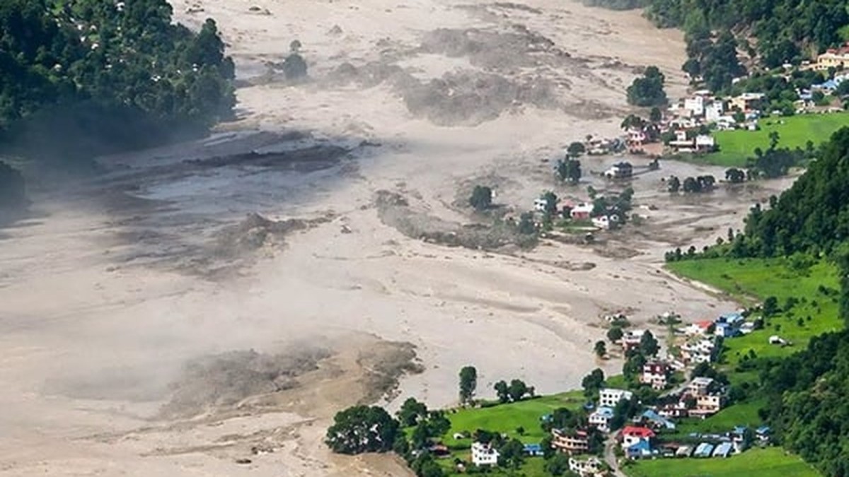
In the wake of the August 26, 2026 Bhotekoshi‑Trishuli flood—described in the field as a “mountain tsunami”—the imperative to translate Earth observation of the Hindu Kush Himalaya (HKH) into concrete regional preparedness has become starkly evident. The disaster, triggered by a massive rock‑ice avalanche that cascaded into the Chhochen Khola and then the Lhende Khola, claimed more than 1,400 lives in Nepal and inflicted additional casualties in China and India. It also disrupted the Gyirong Port, the principal border crossing for trade between Nepal and China, and prompted heightened alerts along the India‑Nepal frontier. This article examines the scientific underpinnings of the flood, the broader climate risks confronting the HKH, and the policy pathways that ministries such as the Ministry of Foreign Affairs (MOFA), the Ministry of Environment (MOE), and research institutions like the International Centre for Integrated Mountain Development (ICIMOD) and the Korea Institute for International Economic Policy (KIEP) are pursuing to move from observation to preparedness.
Scientific Context of the August Flood
The August 26 event unfolded when a rock‑ice slope on the northern face of Mount Langtang Lirung collapsed into the Chhochen Khola, generating seismic energy equivalent to a magnitude‑5.2 earthquake. The resulting debris flow surged downstream, merging with the Trishuli River and ultimately reaching the Gyirong Port on the China‑Nepal border. Satellite imagery and field surveys confirmed that the avalanche was the immediate trigger, but the underlying vulnerability stems from accelerating cryospheric change across the HKH.
Integrated Earth observations—including visual, thermal, and synthetic aperture radar (SAR) remote sensing—have documented a persistent loss of glacier mass averaging roughly half a meter of ice thickness per year. ICIMOD’s 2026 assessment notes that this rate is about twice the pre‑2000 average, with debris‑covered glaciers in the Everest region thinning at up to 1.56 m per year and experiencing flow deceleration. These trends destabilize surrounding slopes, as thawing permafrost and degrading paraglacial moraines increase the likelihood of rock‑ice avalanches and complex hazard chains, as exemplified by the August flood.
Regional Climate Dynamics and Flood Risk
The flood occurred amid a broader pattern of extreme weather across South Asia. By September 27, monsoon‑driven flooding in India had claimed at least 56 lives, while Nepal reported an additional 14 deaths. Rivers such as the Ganga, Gandak, Koshi, Budhi Gandaki, and Bagmati were reported above danger levels. Neighboring Pakistan recorded 199 deaths since June 26, and Bangladesh experienced mass strandings of over one million people across seven districts in July due to prolonged heavy rain.
The World Risk Report 2025 places Bangladesh, Pakistan, and India among the highest‑risk countries globally for flooding. Notably, per‑capita greenhouse gas emissions in these nations—2.5 t CO₂e for India, 1 t for Pakistan, and 0.8 t for Bangladesh—remain well below the global average of 6.4 t. This disparity underscores a climate‑inequality dimension: countries contributing relatively little to global emissions bear a disproportionate share of climate‑related hazards.
Human and Economic Consequences
The immediate human toll of the Bhotekoshi‑Trishuli flood was severe: more than 1,400 fatalities in Nepal, over 40 deaths and 50 missing in China, and extensive displacement in India’s border districts. The disaster also destroyed fertile Trishuli valley lands, eliminated millions of tonnes of carbon credits, and inflicted economic damages amounting to billions of dollars. Beyond the immediate loss of life, recurring floods erode agricultural productivity, damage infrastructure, and strain local economies, potentially prompting climate‑induced migration. A World Bank study cited in the source material projects roughly 40 million internal climate migrants across South Asia by 2050.
These cascading impacts highlight the necessity of integrating scientific data with policy frameworks to mitigate future losses. The Ministry of Foreign Affairs (MOFA) of South Korea, in coordination with regional partners, has emphasized the importance of cross‑border data sharing, while the Ministry of Environment (MOE) has advocated for joint early‑warning systems that incorporate satellite‑derived hazard maps.
Current Gaps in Observation and Monitoring
Despite advances in remote sensing, significant gaps persist in ground‑based monitoring across the HKH. Field observations remain limited due to logistical challenges, resource constraints, and safety risks. Consequently, long‑term measurements of glacier mass balance, snow cover, and permafrost conditions are sparse. Cloud cover and steep terrain further restrict the utility of optical satellite data, while SAR observations, though valuable for detecting surface deformation, still require ground validation.
Glacial lake inventories derived from satellite imagery illustrate another data shortfall. While the number and surface area of glacial lakes in Nepal have been documented for the period 1977‑2017, critical parameters such as lake depth, volume, dam stability, and hydrological behavior demand in‑situ measurements or higher‑resolution observations. Addressing these gaps is essential for refining hazard models and improving the accuracy of early‑warning systems.
Policy Initiatives and Regional Cooperation
In response to the mounting evidence of climate risk, ministries and think tanks across the region are formulating coordinated strategies. The Korean Ministry of Foreign Affairs (MOFA) has initiated dialogues with China, Nepal, and India to establish a multilateral framework for sharing Earth observation data and joint disaster‑risk reduction exercises. Parallelly, the Korean Ministry of Environment (MOE) is supporting capacity‑building programs that train local officials in interpreting satellite‑derived hazard maps and integrating them into community‑level preparedness plans.
Think tanks such as the Asan Institute for Policy Studies and the Korea Development Institute (KDI) have published policy briefs urging the creation of a regional HKH observatory that would pool satellite data, field measurements, and modeling expertise. The KDI’s recommendations include establishing a standardized data portal, harmonizing early‑warning protocols, and securing funding for ground‑based sensor networks in high‑risk catchments.
From Observation to Action: Recommendations for Regional Preparedness
Building on the source material, several actionable steps emerge. First, expanding ground‑based monitoring stations in vulnerable basins—particularly along the Chhochen Khola and its tributaries—would complement satellite observations and improve model calibration. Second, developing a shared, real‑time data platform under the auspices of ICIMOD, with contributions from national space agencies, would enable rapid dissemination of hazard alerts across borders.
Third, integrating hazard maps into local land‑use planning is crucial. Municipalities in the Trishuli valley and adjacent districts along the India‑Nepal border should incorporate flood‑risk zoning into building codes and agricultural advisories. Fourth, capacity‑building initiatives led by the Korean MOE and supported by the KDI should focus on training disaster‑response teams in interpreting SAR and thermal imagery for early detection of slope failures.
Finally, fostering community‑level engagement through participatory risk assessments can bridge the observation gap. By involving local residents in data collection—such as reporting lake level changes or unusual melt patterns—authorities can enrich remote‑sensing datasets with ground truth, thereby enhancing the reliability of forecasts.
Looking Ahead: Scholarly Outlook on HKH Resilience
The August 26 flood serves as a sobering illustration of how accelerated cryospheric decay can translate into catastrophic downstream impacts across national boundaries. As the HKH continues to lose ice at rates double those of the early twenty‑first century, the frequency and intensity of rock‑ice avalanches and associated debris flows are likely to rise. Scholarly consensus, reflected in the analyses of ICIMOD and the World Bank, points to an urgent need for integrated observation‑preparedness systems that couple satellite data with robust ground networks.
In the coming decade, the convergence of Korean diplomatic engagement, regional scientific collaboration, and targeted policy reforms offers a pathway to transform raw Earth observation into actionable resilience. By institutionalizing data sharing, standardizing early‑warning protocols, and embedding scientific insights into local planning, the HKH can move from a reactive stance to a proactive posture against climate‑driven hazards. The challenge remains formidable, but the alignment of academic rigor with pragmatic governance—embodied in the coordinated efforts of ministries, think tanks, and research institutions—holds the promise of safeguarding millions of lives and livelihoods in this fragile mountain cradle of Asia.
This article was produced with AI-assisted research and editorial support. Reporting is based on the source material cited below. Sources: The Diplomat; thediplomat.com; Global1.News (01 October 2026).
By Prof. David Park, Staff Writer
What's Your Reaction?
 Like
0
Like
0
 Dislike
0
Dislike
0
 Love
0
Love
0
 Funny
0
Funny
0
 Wow
0
Wow
0
 Sad
0
Sad
0
 Angry
0
Angry
0

East Asia/Technology Correspondent at Global1.News. Seoul-based voice covering Korean politics, technology, business, and culture. Analyzes how technology and geopolitics intersect across East Asia.













Comments (0)