
Uhaachatik Crater Discovery: 390-Million-Year-Old Impact Site Found on Google Maps
— an amateur stargazer just rewrote the map of ancient cosmic violence in Canada by spotting a monster crater on Google Maps while plotting a camping trip. This 25-kilometer scar in Quebec's remote Côte-Nord region is 390 million years old, and it proves once again that the biggest discoveries often hide in plain sight. The find ends a 15-year drought for new Canadian impact sites and pushes our nation to the top of the global crater count. 390-Million-Year-Old Crater Spotted
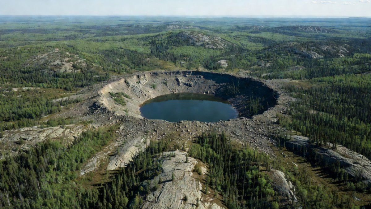
Listen up, folks — an amateur stargazer just rewrote the map of ancient cosmic violence in Canada by spotting a monster crater on Google Maps while plotting a camping trip. This 25-kilometer scar in Quebec's remote Côte-Nord region is 390 million years old, and it proves once again that the biggest discoveries often hide in plain sight. The find ends a 15-year drought for new Canadian impact sites and pushes our nation to the top of the global crater count.
390-Million-Year-Old Crater Spotted on Google Maps
Baie-Comeau, Quebec — August 12, 2024
The Accidental Discovery That Started It All
Joël Lapointe, a 42-year-old amateur astronomer from Montreal, was scrolling through Google Maps satellite imagery in early 2024 while planning a remote camping route near Lake Marsal. Something circular and oddly symmetrical caught his eye — a perfect depression ringed by subtle ridges that no hiking trail or logging road explained. He cross-checked every known crater database and found zero records. Instead of shrugging it off, Lapointe uploaded the coordinates to the Impact Earth database on March 15, 2024. That single upload triggered the chain of events that confirmed a brand-new impact structure. You can bet most people would have kept scrolling, but Lapointe's trained eye for celestial scars made the difference.
The real power here lies in how everyday tools like Google Maps are democratizing planetary science. Lapointe wasn't a funded researcher with satellite access; he was just a guy mapping a camping route who noticed what professionals had missed for decades. This kind of citizen detection exposes gaps in official surveys that rely on outdated imagery or limited field budgets. With remote sensing improving yearly, expect more of these "hidden in plain sight" finds as armchair explorers apply the same scrutiny.
Beyond the thrill, Lapointe's upload highlights a growing trend where public databases accelerate verification. Impact Earth and similar platforms now serve as rapid filters, routing promising leads straight to experts. That cuts years off traditional discovery timelines and forces institutions to respond faster. In an era of shrinking research grants, these volunteer contributions aren't just nice—they're essential for keeping impact science moving.
Canada's vast northern landscapes make this even more significant. Dense forests and limited road access have shielded many features from casual notice, yet satellite views bypass those barriers entirely. Lapointe's find proves the Shield and Côte-Nord still hold surprises, and it pressures mapping agencies to prioritize high-resolution updates in understudied zones.
Scientists Confirm the Real Deal with Hard Evidence
Dr. Gordon Osinski at Western University assembled a field team within weeks and flew into the site last June. Their boots-on-the-ground work uncovered classic impact signatures: shocked quartz grains with those unmistakable parallel fracture planes, plus shatter cones pointing straight at a high-velocity collision. Rock samples collected around the lake's central uplift matched the 390-million-year Devonian timeline. Osinski's team kept Lapointe under strict nondisclosure until peer review cleared the data. Only about 200 confirmed meteorite craters exist worldwide, so every new one carries serious weight. This expedition turned a Google Maps hunch into documented fact.
Shocked quartz and shatter cones aren't just pretty rocks—they're smoking guns that rule out volcanic or glacial origins. The parallel fractures form only under the extreme pressures of hypervelocity impacts, giving geologists an unambiguous timestamp. Osinski's team essentially ran a cosmic crime-scene investigation, and the evidence held up under peer scrutiny. That rigor matters when skeptics question every new claim.
The secrecy pact with Lapointe also reveals how modern science balances public excitement against publication standards. Premature leaks can derail careers and invite misinformation, yet the wait frustrated the discoverer. Once cleared, the July 2026 confirmation opened the floodgates for media and further study. It sets a template for handling future citizen finds without alienating the very people who spot them.
With only roughly 200 verified craters globally, each addition recalibrates asteroid-risk models. Uhaachatik's size and preservation quality make it a benchmark site for testing erosion rates and impact frequency during the Devonian. Funding agencies now have fresh justification to support more ground-truth expeditions instead of relying solely on remote data.
What Actually Happened 390 Million Years Ago
Picture a chunk of space rock the size of a small city slamming into what was then a shallow sea during the Devonian period. The impact vaporized bedrock, blasted out a 25-kilometer-wide bowl, and sent shock waves that fractured quartz crystals deep underground. Over millions of years, erosion and sediment filled the crater, leaving Lake Marsal sitting right in the bullseye today. No dinosaurs existed yet — this predates them by hundreds of millions of years — but the blast would have triggered local tsunamis and atmospheric dust that altered regional climate. The Uhaachatik structure gives us a precise timestamp on one of Earth's quieter but still violent chapters.
The Devonian was already a turbulent time with mass extinctions linked to volcanism and sea-level swings. Adding a 25 km impactor to that mix likely amplified stress on marine ecosystems through dust veils and acid rain. While not a global killer like Chicxulub, Uhaachatik shows how regional events can compound into larger planetary shifts. Paleontologists can now cross-reference fossil layers around the crater for matching die-offs.
Central uplift preservation at Lake Marsal offers a rare window into the rebound mechanics of large impacts. The lake's position marks where the crust rebounded after the initial excavation, a feature usually eroded away elsewhere. Studying its bathymetry and sediment cores could reveal how quickly life recolonized the site post-impact.
Long-term climate ripple effects deserve more modeling. Dust injected into the stratosphere would have cooled the region for years, potentially shifting rainfall patterns across what is now eastern Canada. That data feeds into broader simulations of how extraterrestrial events influence habitability on Earth-like worlds.
Why Only 200 Known Craters Matters More Than You Think
Earth's surface gets recycled by plate tectonics and erosion, so most ancient impacts vanish. Finding a pristine 390-million-year-old example in a relatively accessible part of Quebec is rare. Each confirmed crater helps calibrate models of asteroid flux through time and refines our understanding of extinction events. With climate and planetary defense now hot-button issues, these sites serve as natural laboratories. Lapointe's discovery reminds us that the sky still throws curveballs, and we need every data point we can get.
The scarcity of confirmed sites skews our statistics on near-Earth objects. Every new crater like Uhaachatik tightens the curve on how often 1-km-plus impactors arrive, directly informing deflection strategies. NASA and ESA watch these numbers closely when sizing planetary-defense budgets.
Accessible Canadian examples also lower the barrier for student training. Instead of trekking to Antarctica or the Sahara, researchers can now study a large Devonian crater within driving distance of major universities. That practical advantage accelerates the next generation of impact specialists.
Broader implications reach exoplanet studies. If Earth retains this many visible scars despite active geology, then older, quieter worlds could host even denser crater populations. Uhaachatik becomes a calibration point for interpreting alien surfaces seen by future telescopes.
Canada Now Leads the World with 31 Confirmed Craters
The last new Canadian crater was verified in 2010. This 15-year gap ends with Uhaachatik, bringing our national total to 31 — more than any other country. Most sit in the remote Shield or Arctic because those ancient surfaces escaped heavy erosion. The new site sits in the Côte-Nord, a region already known for mining but not for cosmic history. Canada's vast, under-explored terrain keeps delivering these surprises, and this one proves the country remains ground zero for impact science.
Canada's lead stems from geology, not just luck. The stable craton preserved structures that plate boundaries elsewhere destroyed. That geological advantage now translates into soft power—international teams request access, and Canadian labs publish the defining papers.
Economic angles matter too. Confirmed craters attract geotourism and educational grants. The Côte-Nord could see new visitor centers and guided tours, turning a remote lake into a destination while creating jobs in an area dominated by mining.
Policy-wise, the discovery strengthens arguments for protecting impact sites from development. Once a crater gains scientific status, mining claims face stricter environmental reviews. Uhaachatik may set precedent for balancing resource extraction with heritage preservation.
The Innu Name and Cultural Respect Built In
Researchers consulted the Ekuanitshit Innu council before announcing the name Uhaachatik Crater. The word reflects local geography and traditional knowledge of the land around Lake Marsal. This wasn't a top-down decision — it was a deliberate partnership that honors the people who have lived there for millennia. Indigenous input strengthens the story and sets a standard other discovery teams should follow. Science gains credibility when it respects the stewards of the territory.
Too many past discoveries ignored or erased Indigenous presence. By involving the Ekuanitshit council from the start, the team avoided that trap and gained oral-history insights that satellite imagery could never provide. Those stories may yet reveal earlier observations of the circular feature passed down through generations.
The partnership model also builds trust for future fieldwork. When communities see their language and knowledge reflected in official names, they become active collaborators rather than passive hosts. That cooperation speeds permitting and improves safety in remote areas.
Globally, this approach pressures other crater teams to adopt similar protocols. Journals and funding bodies increasingly require evidence of local engagement, and Uhaachatik now serves as a positive case study in ethical naming practices.
What's Next for Uhaachatik and the Rest of Us
Dr. Osinski will present the full findings at the Annual Meeting of the Meteoritical Society in Germany next month. Further expeditions will map the crater's subsurface and hunt for any preserved meteorite fragments. Lapointe, now out of secrecy, plans public talks to inspire other citizen scientists. You can fire up Google Earth right now and hunt for your own circular anomalies in remote areas. Support local astronomy clubs, push for more funding of impact research, and demand that governments protect these sites from development. The next crater could be sitting in your satellite view — go look.
Subsurface mapping will use ground-penetrating radar and seismic surveys to trace the full extent of the central uplift and any buried melt sheets. Those datasets could reveal whether hydrothermal systems once operated inside the crater, potentially preserving microbial life signatures relevant to astrobiology.
Lapointe's upcoming talks will likely emphasize persistence over credentials. His story shows that pattern recognition skills honed by stargazing translate directly to terrestrial discovery. Expect a surge in amateur submissions once the media cycle peaks.
How You Can Join the Search
Start by downloading high-resolution satellite layers in Google Earth or similar free tools and systematically scan remote Canadian lakes for circular depressions. Cross-reference any candidates against existing crater databases before uploading coordinates to Impact Earth or contacting university geology departments. Lapointe's success proves one careful observer can change the map.
Join local astronomy or geology clubs that run citizen-science workshops on impact features. These groups often partner with researchers for training sessions and can connect you to verification networks. Funding campaigns for new expeditions also need public support—write your representatives and back grants that prioritize field confirmation over pure modeling.
Protect what we already have by advocating for site preservation. Push provincial governments to designate confirmed craters as protected zones before mining or logging interests move in. The next big find is waiting in your satellite view; the only question is whether you'll be the one to spot it.
By Jessica Ali, Staff Writer
This article was produced with AI-assisted research and editorial support. Reporting is based on sources cited in the article.
What's Your Reaction?
 Like
0
Like
0
 Dislike
0
Dislike
0
 Love
0
Love
0
 Funny
0
Funny
0
 Wow
0
Wow
0
 Sad
0
Sad
0
 Angry
0
Angry
0

Editor-in-Chief at Global1.News. Atlanta-based journalist who cuts through the BS and tells it like it is. Lead anchor, host, and the voice you hear when the spin stops and the truth starts.















Comments (0)