
Twin Waterspouts Over San Francisco Bay, Then a Tornado Warning in Santa Cruz County
Twin waterspouts spun over San Francisco Bay on Monday, a sight NOAA's storm events database has not recorded there in 28 years, then a tornado warning covered rural Santa Cruz County and expired without a confirmed touchdown. A stronger storm hits Wednesday.
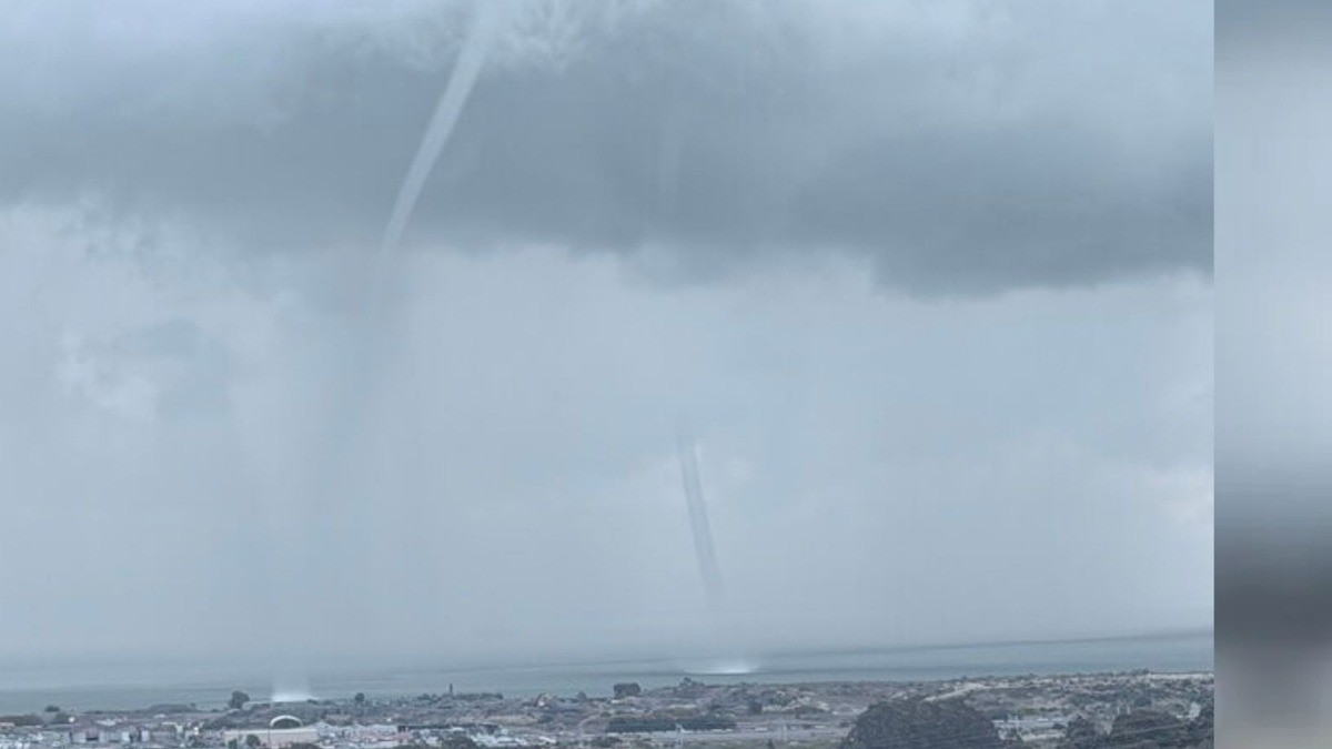
Two funnels dropped out of the overcast over San Francisco Bay shortly before noon on Monday, and by early afternoon a tornado warning covered a rural stretch of the Santa Cruz Mountains. The funnels never reached land. The warning expired without a confirmed touchdown. A stronger storm is already pointed at the same coast for Wednesday.
Twin Waterspouts Over San Francisco Bay, Then a Tornado Warning in Santa Cruz County
San Francisco, California - Monday, Nov. 16, 2026, put a marine warning over the bay, a tornado warning over the Santa Cruz Mountains and a coastal school into its interior room, all before the afternoon was out. The next system arrives Tuesday night.
Two Funnels Over the Bay
Two waterspouts formed over San Francisco Bay shortly before noon on Monday and stayed visible for several minutes, spinning up between San Francisco International Airport and Candlestick Park, the San Francisco Chronicle reported. Colin McCarthy watched the pair for about five minutes before they dissolved back into the overcast. A special marine warning covering bay waters south of the Bay Bridge ran from 12:06 to 12:30 p.m. and stated plainly what such funnels can do: "Waterspouts can easily overturn boats and create locally hazardous seas." These did not. A Weather Service meteorologist told Surfer the pair dissipated without making landfall and noted that the phenomenon can be difficult to detect on radar. ABC7 Bay Area, citing NOAA's storm events database, reported that no waterspouts have been recorded over the bay in 28 years. NBC Bay Area reported no injuries and no property damage.
Twelve Forty-Seven in the Afternoon
At 12:47 p.m. PST the Weather Service office in San Francisco issued a Tornado Warning for West Central Santa Cruz County, in effect until 1:30 p.m. "At 1247 PM PST, a severe thunderstorm capable of producing a waterspout was located 8 miles southwest of Ben Lomond, or 10 miles west of Santa Cruz, moving southeast at 15 mph," the warning read, for "Mainly rural areas of West Central Santa Cruz County." It added the line that explained the ocean connection: "Possible waterspout over the ocean moving onshore." The instruction to anyone in the path was to get into an interior room on the lowest floor of a well-built building, away from windows. A 1:07 p.m. update quoted by the Sacramento Bee put the storm six miles west of Santa Cruz and warned: "Expect damage to mobile homes, roofs, and vehicles." The warning expired at 1:30 p.m. No reports of a tornado forming had come in as of about 2 p.m., ABC7 reported.
When Two Warnings Do Not Agree
The written record of that afternoon does not agree with itself, and the differences are worth naming. ABC7's live blog describes two tornado warnings issued at 1 p.m., one for the Boulder Creek area and one for Davenport. The Weather Service's own archived text describes a single warning covering West Central Santa Cruz County. The same live blog carried a card putting the expiry at 1 p.m., while the warning text, NBC Bay Area and the Sacramento Bee all put it at 1:30. Its estimate of the storm's position moved too, from 10 miles west of Santa Cruz to six. The Guardian kept it broad: "Rare tornado warnings were in effect for parts of Santa Cruz county through Monday afternoon." Rolling Out reported that the warning "has since expired, and it was not immediately clear whether a tornado touched down." What no account disputes is the sequence: a marine warning at noon, a tornado warning at 12:47, and an all-clear by half past one.
Why These Were Not Supercell Tornadoes
The Weather Service's Area Forecast Discussion, issued at 3:04 p.m. Monday, described what radar had shown as transient rotational signatures and then said so directly. "Given some of the photographs received, the convection we've been dealing with is more of a non-mesocyclonic variety," forecasters wrote. Rotation in that kind of storm comes from "tilting and stretching of near surface vorticity upward into convection," and most of it carries no lightning at all, unlike a classic supercell, which draws its spin from deep-layer wind shear. Surface-based CAPE was running 200 to 500 joules per kilogram, corroborated by afternoon ACARS readings from San Francisco, San Jose and Oakland. The forecasters expected the landspout and waterspout threat to fade as daytime heating was lost. The same discussion announced a Cold Weather Advisory for the North and East Bay interior valleys and the southern Salinas Valley overnight.
Pacific Elementary Went to the Interior Room
Heavy rain led staff at Pacific Elementary School in Davenport to move students indoors and away from windows, NBC Bay Area reported. Joel Kauffman, a Davenport parent, watched the system come in from the horizon: "Basically from almost sea level going up thousands of feet coming at you, like darkness that you can't see past." He went on: "I couldn't tell because it was the horizon to horizon. It was a huge wall, stretching out to the ocean and up to the mountains." Eric Gross described the school's response: "We got everyone indoors, closed the doors and windows, then closed the blinds and curtains and then moved everyone away from the windows... and spent the rest of the time hunkered down." That is the routine safety officials urge everywhere: put walls between people and glass before the warning arrives. Hail was reported further inland, in Richmond.
The Weekend That Wore the Coast Down
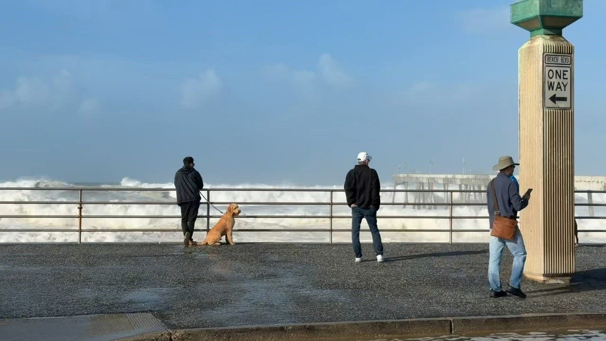
Most of the visible damage came over the weekend, before the funnels. Waves above 50 feet were recorded Saturday in San Mateo County, the Associated Press reported. The Guardian put the biggest sets at 50 to 60 feet at the Mavericks break, where surfers still paddled out, and counted about 270 homes in Santa Cruz County under evacuation warnings. Pacifica took the worst of it: large waves crashed over its seawall and flooded city streets, and every half hour or so a wave that appeared double the size of the last one pushed water hundreds of feet inland, the San Francisco Chronicle reported. Erin Shea, a renter at the end of Elder Lane, said floodwater damaged belongings in her garage. Wind gusts to 64 mph hit Sonoma County, CNN reported. "Stay out of the water, stay off rocks and jetties, and never turn your back on the ocean!" the Weather Service wrote.
Capitola's Wharf, Rebuilt and Battered Again
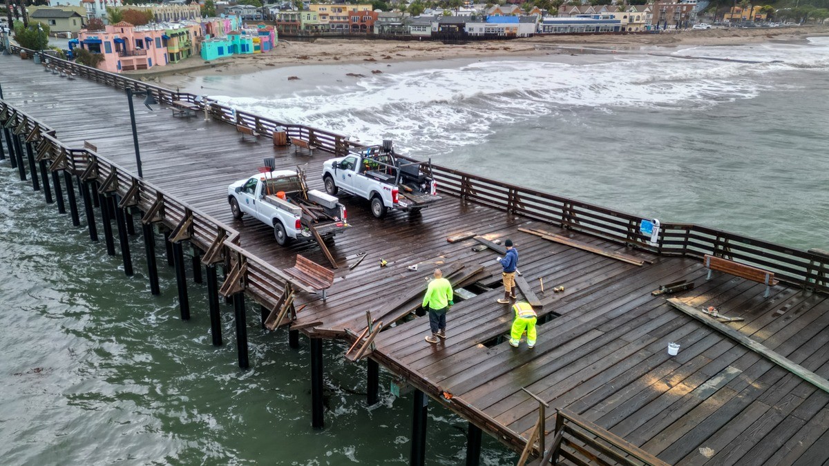
Capitola city crews were repairing the Capitola Wharf on Monday after last week's storm and high surf caused minor damage to deck boards, railings and two piles, Lookout Santa Cruz reported. Engineers were due on site to judge whether the pilings had taken structural damage, with results expected later Monday. The wharf stays closed until further notice. Benches and light poles came through fine, the interpretive signs held, and the memorial plaques were recovered. The Santa Cruz County Sheriff's Department and the city lifted the evacuation warning issued Friday and reopened the Esplanade to traffic, and businesses along it reported no damage. The surf washed out the bottom of the Hooper Beach ramp and flooded the Riverview path. This is a wharf that reopened in September 2024 after a $10.6 million rebuild, having been wrecked in the storms of January 2023. Officials now warn that king tides around Thanksgiving and Christmas could flood the village again.
What Is Still Coming
The next system arrives Tuesday night and runs into early Friday morning, with the heaviest impacts Wednesday and Thursday, according to a forecast briefing the Weather Service released before 4 a.m. Monday. ABC7 meteorologist Drew Tuma called it a strong Level 2 storm on the station's storm impact scale, with room to be upgraded to a Level 3 as it closes in. A Flood Watch covers the North Bay from 4 a.m. Wednesday to 4 a.m. Thursday, NBC Bay Area reported. The Weather Service posted a High Wind Warning for the East Bay Interior Hills around Altamont Pass, with south winds of 25 to 35 mph and gusts to 70 mph, and a Wind Advisory for the valleys and the Pacific Coast with gusts to 50 mph. "Winds this strong can make driving difficult, especially for high profile vehicles," it warned. A Beach Hazards Statement runs through 4 p.m. Wednesday, and the Weather Service lists both Wednesday and Thursday as high-risk days for high surf, strong winds, thunderstorms and widespread rain.
The Rain Numbers, and Why They Do Not Match
Rainfall forecasts for the midweek storm do not agree, and the gap is wide. The Guardian reported 1.5 to 6 inches across the Bay Area. CNN reported 1 to 2 inches across much of the region, with 3 to 4 inches possible in spots, especially in the coastal mountain ranges. Both are describing the same front; the Guardian's range spans the whole region, while CNN's figures are pitched to most of it, with higher amounts in favored terrain. Much of the heaviest rain could fall in just three to six hours as the front crosses, CNN reported, with showers trailing it through Thursday. The Weather Prediction Center put those areas at a Level 2 of 4 risk for flooding rain on Wednesday. The Weather Service office in Los Angeles called the system "the first storm of the season with truly widespread moderate to heavy rain and high elevation mountain snow." A few spots could see 3 feet of snow or more.
The El Niño Underneath All of It
Underneath the week's warnings sits a much larger pattern. "An atmospheric river is pretty much what it sounds like: a long, narrow plume of moisture that can flow thousands of miles, like a fire hose in the sky," CNN explained, reporting that California should expect plenty more of them "as a potentially historic super El Niño boosts the state's odds of a wet winter." The Associated Press reported that the ongoing super El Niño has warmed the ocean, increasing the volume of seawater. The Guardian reported that this year's El Niño is predicted to be the strongest ever recorded, that scientists have warned it will act as a "risk multiplier," and that some research suggests global heating is making El Niños more powerful. Brian Garcia, a Weather Service meteorologist, put the week plainly: "It's going to be a busy couple of weeks - be ready." Santa Clara County fire officials urged residents to check road conditions and pack a go-bag with medications, a first-aid kit, documents and flashlights.
This article was produced with AI-assisted research and editorial support. Sources: ABC7 Bay Area, NBC Bay Area, CNN, The Guardian, the San Francisco Chronicle, the Sacramento Bee, the National Weather Service office in San Francisco, Lookout Santa Cruz, KSBW, the Associated Press, Surfer, Rolling Out and Warning Vector. Photographs: a viewer image of the twin waterspouts over San Francisco Bay credited by ABC7 Bay Area to Erin Wikle; a sneaker wave breaking over the seawall at Pacifica by the San Francisco Chronicle; and damaged decking on the Capitola Wharf by Kevin Painchaud, Lookout Santa Cruz.
By Jessica Ali, Staff Writer
What's Your Reaction?
 Like
0
 Dislike
0
 Love
0
 Funny
0
 Wow
0
 Sad
0
 Angry
0

Editor-in-Chief at Global1.News. Atlanta-based journalist who cuts through the BS and tells it like it is. Lead anchor, host, and the voice you hear when the spin stops and the truth starts.















Comments (0)