
NISAR Radar Captures Hummingbird Pattern in Antarctic Ice
In the vast, frozen expanse of East Antarctica, a chance radar snapshot has revealed an astonishing hummingbird etched in ice, sparking wonder while unlocking critical clues about our planet's changing climate. This striking image from the NISAR satellite not only captivates the public imagination but also highlights groundbreaking international collaboration between NASA and ISRO in monitoring Earth's most remote regions.
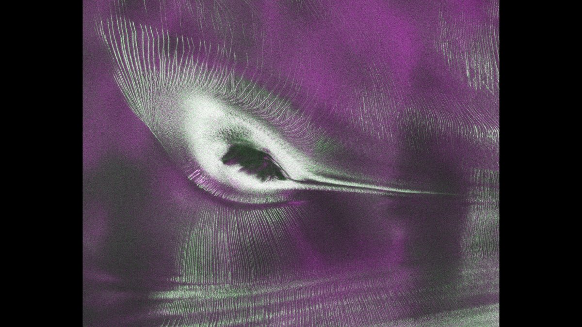
In the vast, frozen expanse of East Antarctica, a chance radar snapshot has revealed an astonishing hummingbird etched in ice, sparking wonder while unlocking critical clues about our planet's changing climate. This striking image from the NISAR satellite not only captivates the public imagination but also highlights groundbreaking international collaboration between NASA and ISRO in monitoring Earth's most remote regions. As data pours in from dual-frequency radars, scientists gain unprecedented tools to track ice dynamics that could reshape global sea levels.
NISAR Radar Unveils Hummingbird Pattern in Antarctic Ice
New Delhi, India – 24 July 2026 — A remarkable radar image from the NISAR satellite has unveiled an unexpected hummingbird-shaped pattern etched into the Antarctic ice, offering both visual intrigue and vital scientific insights into glacier movement and climate change.
The Hummingbird Pattern Beneath Antarctic Ice
NISAR, the joint NASA-ISRO Synthetic Aperture Radar satellite launched on 30 July 2025 from India's Satish Dhawan Space Centre in Sriharikota, has produced an image of Nunatak Zaterjavshijsja, a mountain peak in East Antarctica protruding through a stream of ice flowing northeast toward the ocean. The radar image, captured during instrument calibration in August 2025, reveals intricate crevasse patterns that form what appears to be a hummingbird shape in the frozen landscape. The hummingbird image itself serves a dual purpose: it draws public attention to the mission while delivering genuine scientific value. The crevasse patterns visible in the radar data allow glaciologists to calculate ice flow direction, estimate strain rates, and identify zones where the glacier bed topography influences surface movement.
The Science Behind the Hummingbird
The obstruction created by the nunatak causes stresses in the moving glacier, heavily fracturing the surrounding ice surfaces. The deep cracks, known as crevasses, appear as sharp green lines in the false-colour radar image. Magenta areas represent smoother ice surfaces where signals returned with horizontal polarization, while green areas show volume scattering where radar waves partially penetrated the snow and ice before reflecting off irregular surfaces. With the public data release on 20 July 2026 via NASA and ISRO archives, researchers worldwide will be able to analyse Antarctic ice dynamics, supporting collaborative studies that advance both glaciology and climate science.
Dual-Band Radar: A First for Earth Observation
NISAR is the world's first satellite to carry two different radar frequencies — L-band at 24-centimetre wavelength and S-band at 12-centimetre wavelength — on a single platform. The L-band instrument, provided by NASA, can penetrate deeper through ice, snow, and vegetation canopies, revealing subsurface structures. The S-band radar, built by ISRO, provides complementary surface detail that enhances the overall picture of ice dynamics. Together, the two instruments scan nearly all of Earth's land- and ice-covered surfaces once every 12 days. The L-band and S-band radars on NISAR operate in complementary frequency ranges that allow scientists to distinguish between surface and subsurface ice features across Antarctica. L-band signals at 24 centimetres wavelength penetrate several metres into dry snow and firn, revealing internal layers and basal conditions that optical sensors cannot detect. S-band signals at 12 centimetres provide higher-resolution surface texture data, enabling researchers to map crevasse fields at unprecedented detail. This dual-frequency capability means NISAR can simultaneously track surface melting, snow accumulation, and deep ice deformation in a single pass. The synthetic aperture radar technique works by emitting radar pulses from successive orbital positions and combining the returns electronically. This synthesises the effect of a much larger antenna — several kilometres long — allowing NISAR to achieve resolutions of 5 to 10 metres from an orbital altitude of 747 kilometres. The polarization diversity further enhances discrimination: horizontally polarised signals that return unchanged indicate smooth surfaces like wind-packed snow, while vertically polarised returns reveal volume scattering from fractured ice, buried layers, or rough terrain.
ISRO's Role and India's Space Science Milestone
NISAR represents India's most significant collaborative satellite mission with NASA, demonstrating ISRO's growing capability in advanced Earth observation systems. ISRO contributed the S-band radar system and the spacecraft bus, alongside the launch vehicle and launch operations from Sriharikota. India's Antarctic research stations — Bharati and Maitri — complement these orbital observations by providing ground-truth data for ice sheet studies. The successful first year of NISAR operations positions India as a key partner in global climate monitoring infrastructure. ISRO's contribution of the S-band radar system represents a significant technological achievement for the Indian space agency. The S-band transmitter and receiver electronics were designed and built at ISRO's Space Applications Centre in Ahmedabad, drawing on expertise developed through India's RISAT series of radar imaging satellites. The spacecraft bus, also built by ISRO, provides power, thermal control, and attitude control for the 2,800-kilogram satellite. Launch from the Satish Dhawan Space Centre marked the heaviest interplanetary-class payload ever launched from Indian soil, requiring the Geosynchronous Satellite Launch Vehicle Mk II in its most powerful configuration. India's polar research programme has expanded significantly in recent decades. The Bharati research station, commissioned in 2012, and the older Maitri station, established in 1989, provide platforms for glaciological and climate research on the Antarctic continent. Indian scientists have used data from these stations to study ice core samples, measure atmospheric composition, and track changes in sea ice extent. NISAR's orbital observations will now complement these ground-based measurements, giving Indian researchers a space-to-ice perspective that was previously accessible only through foreign satellite data.
What the Data Means for Climate Science
East Antarctica holds the largest ice sheet on Earth, containing enough frozen water to raise global sea levels by approximately 53 metres if fully melted. Understanding crevasse formation and ice flow dynamics is critical for predicting how glaciers will respond to warming oceans and atmospheric temperatures. Fracture patterns revealed by NISAR's radar can help glaciologists identify zones where ice shelves may weaken and accelerate, feeding into more accurate sea level rise projections. East Antarctica's ice sheet contains approximately 26.5 million cubic kilometres of ice, making it by far the largest reservoir of fresh water on Earth. Even a small fraction of this mass entering the ocean would have severe consequences for coastal populations. NISAR's ability to detect changes in ice flow velocity, crevasse propagation rates, and grounding line positions — where ice transitions from land-based to floating — provides data essential for improving the models used by the Intergovernmental Panel on Climate Change (IPCC) in its regular assessment reports.
Public Data Access Opens New Research Frontiers
On 20 July 2026, the NISAR mission team opened public access to data from both L-band and S-band radars, processed and archived by NASA and ISRO. Seongsu Jeong, the signal analysis engineer who produced the hummingbird image at NASA's Jet Propulsion Laboratory, explained the significance of radar observation: "First, it's a beautiful image, with rich details of features that provide insights into how the glacier is moving. Then, because radar can often see through snow and deep into the ice, NISAR can observe fundamentally different properties of Antarctic ice than can be seen in optical imagery." Researchers and glaciology teams worldwide can now use NISAR data for studies ranging from ice sheet mass balance to iceberg calving dynamics.
Beyond Antarctica: NISAR's Global Reach
While the hummingbird image has captured public imagination, NISAR has already observed urban street grids, agricultural fields, landslides, earthquakes, and subsidence in Mexico City during its commissioning phase. The mission's capability to monitor land movement, forest structure, wetland changes, and natural hazards makes it one of the most versatile Earth observation platforms in orbit. For India, the mission provides data that can support agricultural monitoring, disaster response, and infrastructure planning across the subcontinent.
— By Dr. Raj Patel, Staff Writer
This article was produced with AI-assisted research and editorial support. Reporting is based on sources cited in the article.
What's Your Reaction?
 Like
0
Like
0
 Dislike
0
Dislike
0
 Love
0
Love
0
 Funny
0
Funny
0
 Wow
0
Wow
0
 Sad
0
Sad
0
 Angry
0
Angry
0

India/South Asia Correspondent at Global1.News. Analytical voice with a background in science and health journalism. Based in New Delhi, covering Indian politics, education, healthcare, technology, and policy. Breaks down complex data into clear, actionable reporting.















Comments (0)