
Hurricane Polo Forecast to Hit Category 5 as Mexico Extends Storm Watch to Manzanillo
Hurricane Polo was still rapidly intensifying off Mexico's Pacific coast on Monday night, with the National Hurricane Center forecasting a potentially catastrophic Category 5 by Wednesday and Mexico extending a tropical storm watch northward to Manzanillo. No landfall or casualties have been reported.
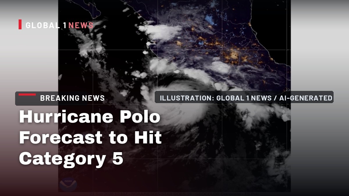
Hurricane Polo is forecast to become a Category 5 hurricane off Mexico's Pacific coast by Wednesday, and Mexico has extended a tropical storm watch northward to Manzanillo as the system intensifies rapidly over exceptionally warm ocean water. No landfall has occurred. No casualties have been reported. And the official forecast keeps getting worse.
Hurricane Polo Forecast to Hit Category 5 as Mexico Extends Storm Watch to Manzanillo
Mexico City, Mexico - Polo was a tropical storm on Monday morning and a Category 1 hurricane by mid-day. By Monday night, the National Hurricane Center's Advisory Number 6 carried the banner headline that Polo is "still rapidly intensifying and forecast to become a Category 5 hurricane tomorrow." Coastal states from Guerrero to Colima are on alert, and the forecast cone runs the storm parallel to the southwestern coast, with AccuWeather warning its reach could extend toward the tourist hubs of Acapulco, Puerto Vallarta and Guadalajara.
Polo as It Stands Tonight
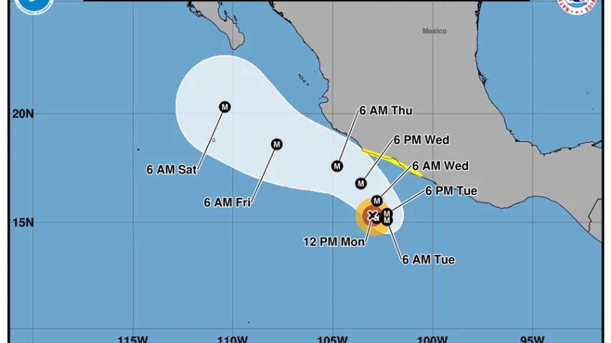
Hurricane Polo is still rapidly intensifying off Mexico's Pacific coast, and the National Hurricane Center says it is forecast to become a Category 5 hurricane by Wednesday. In its 900 PM CST Public Advisory Number 6, the NHC put Polo's maximum sustained winds at 110 mph (175 km/h) with higher gusts, minimum central pressure at 964 mb (28.47 inches), and the center at 15.0N, 102.3W — about 305 miles (495 km) south-southeast of Manzanillo and about 190 miles (310 km) south-southwest of Zihuatanejo. The storm is moving east-southeast, or 105 degrees, at 5 mph (7 km/h). Hurricane-force winds extend outward up to 30 miles (45 km) from the center; tropical-storm-force winds reach out up to 80 miles (130 km). The government of Mexico extended a Tropical Storm Watch northward from Punta San Telmo to Manzanillo, so the watch now runs from Tecpan de Galeana to Manzanillo. Interests elsewhere along the southwestern Mexico coast should keep monitoring, the NHC added, because additional watches and warnings could be necessary tomorrow. Folks, this is a Monday-night snapshot of a storm that has not finished changing.
The Forecast That Put Forecasters on Notice
The banner headline on Advisory 6 reads that Polo is "still rapidly intensifying and forecast to become a Category 5 hurricane tomorrow." The agency says rapid intensification is forecast over the next day or so, that Polo is expected to become a major hurricane shortly, and that it is forecast to become a potentially catastrophic Category 5 hurricane by Wednesday. Fox Weather reports the NHC projects Category 3 winds of 120 mph by Tuesday morning and potentially 160 mph by late Tuesday, with peak forecast intensity listed at 160 mph, Category 5, from Wednesday evening into Thursday morning. Rapid intensification is defined as sustained winds increasing by at least 35 mph in 24 hours. National Hurricane Center forecaster Eric Blake wrote in Monday's update that Polo's chances of rapid intensification were "as high as I have ever seen them," and said the agency expects Polo to be "a small but very dangerous hurricane by Tuesday and beyond." Category 5 is the forecast, not the current reality, and Polo has not made landfall. The NHC expects the core to remain offshore, tracking along the coast of western Mexico but staying offshore, according to the Associated Press, and Reuters reports forecasters cautioned that uncertainty remained about the eventual track because of a wide range in computer model guidance.
Why This One Is Exploding
Forecasters expect explosive strengthening over Pacific waters made exceptionally warm by a strengthening and potentially record El Nino, according to Fox Weather. Polo's intensification is being fueled by ocean temperatures above 87 degrees Fahrenheit, and NOAA's latest monitoring shows marine heat wave conditions across broad stretches of the tropical eastern Pacific. The environment is also unusually conducive in the other respects that matter: light wind shear, meaning relatively small changes in winds with height, and an abundant moisture supply. For scale, Fox Weather notes that Hurricane Patricia's wind increase of about 120 mph in 24 hours in 2015 is the record for the basin, and that a tropical storm reaching Category 5 in under three days would put Polo in rare territory. The NHC's own advisory language is blunt — rapid intensification forecast, a major hurricane expected shortly, and a potentially catastrophic Category 5 projected by Wednesday. That is the documented basis for the alarm: warm water, low shear, moisture, and an El Nino backdrop. Nothing in the official record attributes this to anything else.
What Mexico Is Telling People on the Coast
Mexico's Coordinacion Nacional de Proteccion Civil posted Monday that Polo was then a Category 1 hurricane, located 305 km south-west of Zihuatanejo, Guerrero, and 435 km south-south-east of Manzanillo, Colima, and that its circulation reinforces the probability of rain of varying intensities in Jalisco, Colima, Michoacan, Guerrero and other states. Mexico's National Meteorological Service predicted Polo would bring heavy rainfall to Pacific coastal regions, potentially raising river and stream levels, triggering flooding and mudslides. Jalisco's Unidad Estatal de Proteccion Civil y Bomberos lists Jalisco, Colima, Guerrero, Michoacan and Oaxaca on alert. The SMN and the US National Hurricane Center established the watch zone from Tecpan de Galeana, Guerrero, to Punta San Telmo, Michoacan, warning that Polo's trajectory will be "erratic," per Mexico News Daily, and that it is expected to curve and move parallel to the coasts of Colima, Michoacan and Guerrero. Telesur and Mexico News Daily report waves of 2 to 3 metres expected in Guerrero and Michoacan, up to 2.5 metres in Oaxaca, and 1.5 to 2.5 metres in Jalisco and Colima, with wind gusts of 40 to 60 km/h along the coasts of Michoacan, Guerrero and Oaxaca and 30 to 50 km/h in Jalisco and Colima. The SMN and Conagua urged the public to follow official recommendations and not to spread rumors or unverified information.
The Coast Inside the Cone
Polo is moving toward the east-southeast near 5 mph (7 km/h), a general motion expected to continue overnight, with a sharp turn toward the northwest and west-northwest anticipated late Tuesday into Wednesday, the NHC says. On the forecast track, the core is expected to be near or south of the coast of southwestern Mexico during the next few days, and tropical storm conditions are possible within the watch area by early Wednesday. The rainfall is where the acute danger sits: Polo is expected to produce totals of 4 to 8 inches (10 to 20 cm), with isolated maximum totals up to 12 inches (30 cm), across coastal portions of Guerrero and Michoacan through Thursday. The NHC says that rainfall may produce life-threatening flooding and mudslides, especially in areas of mountainous terrain. AccuWeather said the storm's reach could extend out toward tourist hubs including Acapulco, Puerto Vallarta and Guadalajara, while southern Baja California Sur, including the Los Cabos area, could also see rough surf and strong gusts later this week, according to Reuters. No landfall has occurred. No casualties, damage or evacuation figures have been reported.
Odalys, Fifteen-E, and a Pacific Running Hot
Polo is not alone out there. The Associated Press reports Tropical Storm Odalys was far from land but expected to become a hurricane by midweek, with maximum sustained winds Monday of 50 mph (85 kph), located just over 1,400 miles (2,253 km) west-southwest of the southern tip of Mexico's Baja California peninsula and moving northwest at 8 mph (13 kph). Fox Weather reports Odalys is forecast to peak at Category 1 strength, but that its track takes it on an unusual eastward path, bringing it closer to Polo and raising the possibility of interaction later this week. That is a possibility, not a certainty — no merger or specific interaction is confirmed. Separately, the NHC was monitoring an area of low pressure several hundred miles east-southeast of Hawaii with a 90% chance of becoming a tropical depression within seven days, formation likely around midweek, while remnants of Tropical Depression Fifteen-E were expected to redevelop and bring more heavy rain to Hawaii — a state that rarely sees tropical activity. The basin is busy, and it is still September.
The Atlantic's Opposite Year
Here is the contrast that should stop you cold. The Associated Press reports that in the Atlantic Ocean, no hurricanes have formed yet this year, and 2026 has set a record for the longest a season has begun without a hurricane — the effects of this year's El Nino crush storms before they get going. The AP also reports Tropical Storm Fay was weakening in the Atlantic, with top winds down to 45 mph (75 kph), located 445 miles (720 km) south-west of the Azores. Meanwhile, Fox Weather reports this is happening amid a rapidly strengthening El Nino that has supercharged the Pacific, producing 18 named storms across both the Central and Eastern parts of the basin with more than two months remaining in the hurricane season. The New York Times reports Polo is the 16th named storm to form in the Eastern Pacific in 2026. Those two counts are not the same measure — one covers both basins, the other counts only the Eastern Pacific season — and both are attributed as stated. The Pacific is running hot while the Atlantic runs historically quiet, and Polo is the sharpest expression of that split so far.
The Water That Is Headed North
Polo will not make landfall anywhere near the United States, according to Fox Weather. But its moisture is already on the move. Moisture from Polo is streaming into the Southwest and is expected to enhance monsoon thunderstorms over New Mexico beginning Tuesday, and AccuWeather warned that tropical moisture from Mexico is expected to push north through the rest of the week, threatening flash floods in the US Southwest. Fox Weather reports Polo is forecast to slowly move northward this week, likely bringing dangerous surf to Mexico and southern California this weekend, with the West Coast and southwestern US possibly seeing additional impacts — though forecast uncertainty is high. Farther out, forecasters said Polo may never make a true landfall along the coast at all, with many forecast models keeping the center away from land and eventually moving it out into the open Pacific. So the coastal threat to Mexico is rain, surf and wind; the threat farther north is water — and the models are not settled.
What Is Not Known
Precision about the gaps is part of the job. No deaths, injuries, evacuations, rescues, damage totals or economic loss figures have been reported, and there are no casualty numbers in this story. No Category 5 has occurred yet — it is a forecast. Polo has not made landfall. No Mexican federal emergency declaration has been issued, and no California state of emergency or evacuation has been confirmed. No figure exists in the official record for the number of people or tourists at risk, so none is given here. On the storm's own numbers, the record shows how fast this moved through Monday: the 9:00 am CST advisory had 65 mph winds and 997 mb; Reuters reported hurricane status around mid-day local with 80 mph (130 km/h); the Associated Press at 5:05 pm PDT had 90 mph (150 kph); Telesur at 9:37 pm had 130 km/h with gusts to 155 km/h; and Advisory 6 at 9:00 pm CST had 110 mph (175 km/h) and 964 mb. Those are the documented figures, reported as they changed. Anything more than that tonight is guesswork.
What Comes Next
The next official word is the one that matters. The NHC said additional watches and warnings could be necessary tomorrow, and Mexico has already extended the Tropical Storm Watch northward to Manzanillo. The forecast calls for a sharp turn late Tuesday into Wednesday, a major hurricane shortly, and a potentially catastrophic Category 5 by Wednesday, with the core expected to stay near or south of the coast. The gap between what is forecast and what is confirmed is exactly where accountability lives: the advisory numbers get reported as they land, with the source named every time, and no silence filled with numbers nobody has. If you are in the watch area from Tecpan de Galeana to Manzanillo, or anywhere along the southwestern Mexico coast, here is the official guidance from Mexican authorities. Stay informed through SMN and Civil Protection notices. Do not cross rivers, streams or flooded areas. Prepare a family civil-protection plan and keep important documents and an emergency kit to hand. Follow evacuation instructions if necessary. Identify temporary shelters and evacuation routes. Stay away from poles, cables and trees during strong winds. Do not drive on flooded roads. Do not spread rumors or unverified information. Follow the official notices — and check back for the next advisory.
By Jessica Ali, Staff Writer
This article was produced with AI-assisted research and editorial support. Sources: the NOAA National Hurricane Center, the Associated Press, Reuters, Fox Weather, Mexico News Daily, Telesur, AccuWeather, The New York Times, Mexico's Coordinacion Nacional de Proteccion Civil, the Servicio Meteorologico Nacional, Jalisco state civil protection and Conagua.
What's Your Reaction?
 Like
0
Like
0
 Dislike
0
Dislike
0
 Love
0
Love
0
 Funny
0
Funny
0
 Wow
0
Wow
0
 Sad
0
Sad
0
 Angry
0
Angry
0

Editor-in-Chief at Global1.News. Atlanta-based journalist who cuts through the BS and tells it like it is. Lead anchor, host, and the voice you hear when the spin stops and the truth starts.















Comments (0)