
Hurricane Polo expected to reach Category 5 as it nears Mexico’s Pacific coast
As the Pacific waters stir on Monday, residents along Mexico’s western coast brace for what officials warn could become a Category 5 hurricane by mid‑week.
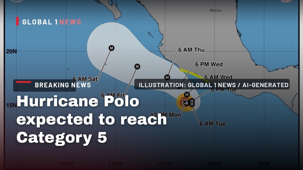
As the Pacific waters stir on Monday, residents along Mexico’s western coast brace for what officials warn could become a Category 5 hurricane by mid‑week. The storm, named Polo, formed off the coast of Guerrero and is already gathering strength, prompting Civil Protection to urge vigilance across several states. While the meteorological data paints a picture of intensifying winds and heavy rain, the true impact will be felt in the homes, farms, and markets of ordinary families who have already endured the scars of recent storms.
From a newborn disturbance to a looming Category 5
At 9 a.m. CST on Monday, Polo was centered about 410 kilometers south‑southeast of Manzanillo and 322 kilometers southwest of Zihuatanejo. By noon, the system had already reached Category 1 status, with sustained winds of 129 kph (80 mph). Meteorologists from Mexico’s National Meteorological Service (SMN) and the U.S. National Hurricane Center warned that the storm is expected to intensify rapidly, potentially achieving Category 5 strength near the coast of Michoacán by Wednesday.
The forecast trajectory is described as “erratic,” with the storm expected to curve and move parallel to the coasts of Colima, Michoacán and Guerrero. A watch zone has been established from Tecpan de Galeana in Guerrero to Punta San Telmo in Michoacán, underscoring the broad swath of coastline that could feel Polo’s effects.
Rainfall and flood risks for vulnerable communities
The SMN predicts that Polo will unleash intense rain across the Pacific coastal states. In Oaxaca and Guerrero, rainfall totals could range from 75 to 150 millimeters, while Michoacán may see very heavy rain of 50 to 75 millimeters. Coastal Jalisco and Colima are also in the path, with expected precipitation of 25 to 50 millimeters. Such amounts, combined with the region’s steep terrain, raise the specter of rising river and stream levels, flooding, and mudslides.
For families living in ejidos and small coastal villages, the threat of flash flooding is especially acute. In recent years, heavy rains have turned arroyos into torrents, sweeping away livestock and damaging modest homes. The warning to remain attentive to SMN alerts is therefore a call to protect not just property, but the very livelihoods that sustain these communities.
Winds and surf: what to expect on the shoreline
Along the coasts of Colima, Michoacán, Guerrero and Oaxaca, winds are expected to range from 10 to 20 kph, with gusts reaching 30 to 50 kph. Though modest compared with the storm’s core, these breezes can still pose hazards for fishermen and market vendors setting up stalls at the tianguis near the beach. Moreover, the storm will generate waves between one and three meters, affecting the same coastal stretches.
Local authorities have urged residents to heed Civil Protection’s recommendations, which include securing boats, avoiding unnecessary travel on coastal roads, and staying away from the surf where sudden rip currents could arise. The combination of wind and surf threatens not only property but also the safety of those who make a living from the sea.
Looking beyond Polo: the broader tropical outlook
While Polo dominates the immediate forecast, the Pacific basin remains active. Tropical Storm Odalys, located over 2,000 kilometers west‑southwest of the southern tip of Baja California, is forecast to become a hurricane by mid‑week. Though currently distant, its development adds another layer of uncertainty for the upcoming weather pattern across western Mexico.
The presence of multiple systems in the Pacific can influence steering currents, potentially altering Polo’s path. Meteorologists continue to monitor Odalys closely, as any shift in its trajectory could affect the timing and intensity of Polo’s approach to the coast.
Historical echoes: remembering recent hurricanes
The memory of Hurricane Otis, a Category 5 storm that devastated Acapulco in September 2024, remains fresh in the minds of many. The city, home to over one million people, is still in recovery, rebuilding homes, schools, and the bustling tourist infrastructure that fuels its economy. A year later, Hurricane John struck coastal Guerrero as a Category 3 storm, reminding the region that the Pacific can produce consecutive, severe weather events.
These recent experiences have shaped the current response to Polo. Communities that were battered by Otis and John have already begun to reinforce homes, clear drainage channels, and stock emergency supplies. The collective memory of loss and resilience informs the heightened vigilance expressed by Civil Protection officials.
Community preparedness and civil protection efforts
Civil Protection’s outreach this week has focused on clear, actionable guidance. Residents are encouraged to stay informed through SMN alerts, to secure loose objects, and to have an emergency kit ready—containing water, non‑perishable food, medication, and important documents. Authorities also stress the importance of following evacuation orders should floodwaters threaten low‑lying neighborhoods.
In many colonias, local leaders are organizing community watches, checking that neighbors, especially the elderly and those with limited mobility, have safe shelter options. These grassroots efforts echo the traditional spirit of mutual aid found in Mexican towns, where a shared sense of responsibility often turns a tianguis into a hub for distributing emergency supplies.
What the coming days mean for everyday life
For the average family in coastal Jalisco, the next few days will likely involve postponing trips to the market, securing boats at the marina, and preparing homes for possible water intrusion. In Oaxaca and Guerrero, farmers may need to protect their fields and livestock from the anticipated heavy rains, while teachers might adjust school schedules in anticipation of hazardous travel conditions.
As Polo gathers strength, the balance between caution and daily routine will be tested. The warning that the storm’s trajectory is “erratic” underscores the need for flexibility—plans may need to shift at a moment’s notice. Yet, the same resilience that helped communities rebuild after Otis and John will guide them through this new challenge, as families gather in their homes, share stories, and look to the future with cautious optimism.
This article was produced with AI-assisted research and editorial support. Reporting is based on the source material cited below. Sources: Mexico News Daily; mexiconewsdaily.com; Global1.News (22 September 2026).
By Rosa Martinez, Staff Writer
What's Your Reaction?
 Like
0
Like
0
 Dislike
0
Dislike
0
 Love
0
Love
0
 Funny
0
Funny
0
 Wow
0
Wow
0
 Sad
0
Sad
0
 Angry
0
Angry
0

Latin America/Andes Correspondent at Global1.News. Based in Bogota, covering politics, environment, energy, and social movements across the Andean region. Passionate about environmental journalism and communities protecting their land.















Comments (0)