
Guatemala Fuego Volcano Eruption Forces Mass Evacuations
Fuego volcano in Guatemala erupted on Monday, sending pyroclastic flows down multiple ravines and prompting evacuations of at least 350 people from El Porvenir and Las Lajitas villages. An orange alert remains in effect as ash columns reached 6,000 meters.
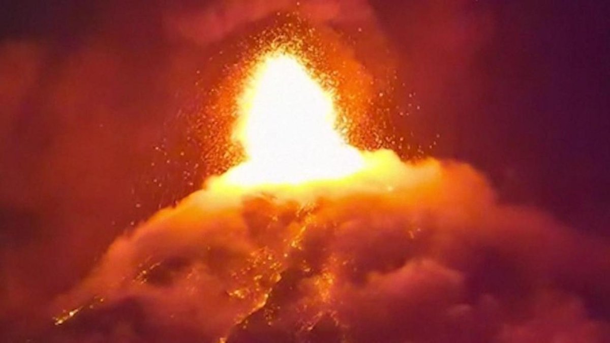
Guatemala's Fuego volcano roared back to life on Monday, sending lava fountains and ash plumes skyward and forcing families from their homes on its slopes. The eruption highlights the constant threat faced by communities living near one of Central America's most active peaks, where rapid evacuations can mean the difference between safety and tragedy. Across Latin America, from the Andes to the Central American isthmus, similar risks test the limits of preparedness in regions shaped by the Pacific Ring of Fire.
Guatemala City, Guatemala — Fuego volcano, standing 3,763 meters high and located just 16 kilometers west of the colonial city of Antigua, began its latest eruption around 08:30 local time on Monday. Guatemala's National Institute of Seismology, Volcanology, Meteorology and Hydrology reported nine higher-amplitude seismic events by 16:00 local time, with pyroclastic density currents traveling 5 to 7 kilometers down the Seca ravine on the western flank. By 20:00 local time the activity had continued for 11.5 hours, with additional flows moving through the Ceniza ravine on the southwestern flank. Ash and gas columns reached between 5,000 and 6,000 meters above sea level, dispersing more than 40 kilometers west initially and later extending up to 130 kilometers southwest.
The Eruption and What Happened
Explosiveness increased throughout Monday, producing a lava fountain 200 to 300 meters above the crater. INSIVUMEH tracked multiple pyroclastic density current pulses and advised civil aviation authorities to exercise caution between 60 and 100 kilometers west of the volcano at altitudes from 4,450 to 6,000 meters. By Tuesday morning the eruption had lasted 23 hours, though intensity showed signs of easing. No immediate impact reached Guatemala City's international airport, yet the government maintained close monitoring of the ongoing activity.
Evacuations and Shelters
SE-CONRED declared an Institutional Orange Alert, the second-highest level, and executive secretary Claudinne Ogaldes urged residents in Escuintla, Chimaltenango, and Sacatepéquez departments to evacuate. Firefighters transported at least 350 residents from the villages of El Porvenir and Las Lajitas to shelters in San Juan Alotenango municipality, where they received makeshift beds in a community hall. Buses were provided for transport, and the Municipality of Escuintla opened additional shelters. The education ministry suspended face-to-face classes in communities within two nearby municipalities, while traffic police closed the road encircling the mountain range that connects the south coast with Antigua. CONRED spokesperson Valeria Urizar emphasized the principle of self-evacuation for those in high-risk zones.
Families in the affected villages left their homes on their own accord out of fear as the volcano's activity built through the day on Monday. Alejandro Garcia, 68, told AFP that since early morning it was active and that night the alarm was raised that they needed to evacuate. At the shelter in San Juan Alotenango, evacuees including families with children settled onto makeshift beds in the community hall after firefighters transported at least 350 residents from El Porvenir and Las Lajitas.
Lidia Ortiz, 40, said that if there were any chance of moving to a different house it would be better because you are always afraid since the volcano does not give any warning. Sonia Vasquez, 50, added that residents have already gotten used to having the volcano constantly active but this time it was really too much. The emotional toll weighed heavily on those now in shelters in Escuintla and San Juan Alotenango as they faced an uncertain stay while CONRED maintained the orange alert.
The Science of Pyroclastic Flows
Pyroclastic density currents represent the greatest threat to communities located 7 to 10 kilometers from the crater, particularly in San Pedro Yepocapa municipality in Chimaltenango Department. These fast-moving rivers of gas, volcanic ash, and rock fragments descended the Seca, Ceniza, Las Lajas, Honda, and Taniluyá ravines on both the southwestern and southeastern flanks. INSIVUMEH confirmed flows through the Las Lajas and Honda ravines starting from 01:15 local time on Tuesday. Residents were instructed to keep windows and doors closed to protect against billowing ash clouds, and the agency warned that further flows and ash emissions remained possible.
INSIVUMEH specialists noted that average seismic amplitude measured through RSAM and thermal radiation generated by recent volcanic material suggest the activity could persist or increase during the following hours. Pyroclastic density currents could also descend into other ravines if the eruption intensifies especially the Ceniza ravine which was affected during recent eruptions. These flows are lethal because of their extreme temperatures and speeds as they race down ravines carrying gas ash and rock fragments that can overwhelm communities within minutes.
The 2018 catastrophe along the Las Lajas ravine remains the reference point where similar currents destroyed an entire village and killed more than 200 people. Ashfall was reported in communities in San Pedro Yepocapa while aviation authorities received advisories to exercise caution between 60 and 100 kilometers west of the volcano at altitudes from 4,450 to 6,000 meters. Residents were told to keep windows and doors closed as further flows remained possible through the five affected ravines.
Echoes of the 2018 Tragedy
More than 200 people died when Fuego erupted in June 2018, many caught in pyroclastic flows that raced down the Las Lajas ravine and destroyed an entire village. Similar flows occurred during this week's activity, renewing memories for survivors who recall the speed and heat of those deadly currents. In recent years, eruptions in 2023 and 2025 prompted evacuations of around 1,200 and more than 500 people respectively, showing that the volcano's pattern of sudden escalation continues to challenge local response systems.
Regional Context in the Ring of Fire
Guatemala sits on the Pacific Ring of Fire, the same tectonic belt that produces frequent seismic and volcanic events across Latin America. Countries such as Chile, Peru, Colombia, and even parts of Brazil's northern border regions share exposure to similar hazards, where vulnerable rural communities often live on fertile volcanic slopes despite the risks. Disaster preparedness varies widely, with limited resources in many areas leaving families dependent on rapid government alerts and self-evacuation. This week's events in Escuintla and Chimaltenango departments underscore how poverty and proximity to active peaks amplify threats for ordinary residents who must balance daily livelihoods against the possibility of sudden displacement.
Across Latin America the same Ring of Fire risks appear in Colombia where Nevado del Ruiz produced the region's worst volcanic disaster in 1985 when a lahar buried Armero and killed more than 20,000 people. Chile's Villarrica Ecuador's Cotopaxi and Tungurahua and Peru's Ubinas are among the active peaks watched by national monitoring agencies as vulnerable rural communities farm the fertile slopes despite the dangers.
Guatemala's CONRED and INSIVUMEH alert systems stand in contrast to areas with fewer resources where poor families often lack timely warnings. The pattern repeats across the region as monitoring networks and early warning systems save lives only when they reach the most vulnerable populations living on the slopes. This week's events in Escuintla and Chimaltenango departments highlight how proximity and limited preparedness amplify threats for ordinary residents.
What Happens Next
CONRED maintained the nationwide orange alert and urged people to avoid slopes and high-risk zones near the volcano. Monitoring by INSIVUMEH continues around the clock, with warnings that additional pyroclastic flows could develop without much notice. Schools near the affected areas remain closed, and aviation precautions stay in place. For communities already in shelters, the focus now shifts to longer-term support while authorities assess whether the current phase of activity will subside or intensify further in the coming days.
INSIVUMEH specialists continue round-the-clock monitoring and warn that activity could persist or increase with pyroclastic flows already confirmed in the five ravines of Seca Ceniza Taniluyá Las Lajas and Honda. The orange alert serves as a signal for continued readiness as authorities urge people to avoid slopes and high-risk zones near the volcano.
Shelters remain open in Escuintla and San Juan Alotenango while education authorities keep face-to-face classes suspended in two nearby municipalities and traffic police maintain road closures around the mountain range. The tourism dimension for Antigua adds another layer of concern as the uncertain timeline means eruptions can subside or escalate within hours leaving families in shelters focused on longer-term support.
By Elena Vasquez, Staff WriterThis article was produced with AI-assisted research and editorial support. Reporting is based on sources cited in the article.
What's Your Reaction?
 Like
0
Like
0
 Dislike
0
Dislike
0
 Love
0
Love
0
 Funny
0
Funny
0
 Wow
0
Wow
0
 Sad
0
Sad
0
 Angry
0
Angry
0

Latin America Correspondent at Global1.News. Based in Mexico City, covering politics, economics, energy, and culture across the region. Brings an on-the-ground perspective to stories spanning from the Rio Grande to Patagonia.















Comments (0)