
Mapped: UK to be hotter than Barcelona as fifth heatwave will bring 36C temperatures
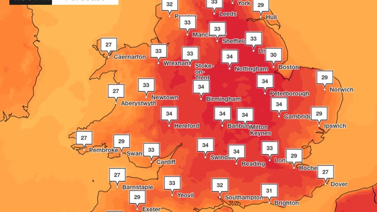
Britain is braced for its fifth heatwave of an extraordinary summer, with the Met Office forecasting temperatures of up to 36C in parts of England this week — hotter than Barcelona, which is expected to peak at just 33C on Friday....
Mapped: UK to be hotter than Barcelona as fifth heatwave will bring 36C temperatures
Britain is braced for its fifth heatwave of an extraordinary summer, with the Met Office forecasting temperatures of up to 36C in parts of England this week — hotter than Barcelona, which is expected to peak at just 33C on Friday. The scorching conditions, which follow a dry, sunny and warm weekend across much of England and Wales, will push the mercury significantly higher from Wednesday onwards, intensifying pressure on the NHS, water companies and emergency services already grappling with the effects of a prolonged drought.
The Met Office has predicted that temperatures will climb "significantly" across the UK this week, rising to between 32C and 34C on Wednesday — the expected peak for much of England, Wales, Northern Ireland and Scotland — before the mercury climbs higher still in parts of East Anglia and the South East, where 36C is possible on Thursday. Deputy chief forecaster Mike Silverstone said the heatwave was expected to be fairly widespread across England and Wales, with humidity levels increasing through the week and making conditions feel more uncomfortable, particularly overnight.
A nation divided: the North-South weather split
The UK has experienced a consistent North-South split in weather patterns across this summer, and this week will be no exception. While England and Wales swelter under high pressure and clear skies, Scotland and Northern Ireland have endured heavy spells of rain over the weekend, with cloud and showers expected to persist in western Scotland and western parts of Northern Ireland. Edinburgh is forecast to reach a comparatively modest 26C on Wednesday, while Leeds will see 30C on the same day, stretching further north to Newcastle-upon-Tyne on Thursday, where temperatures are expected to hit 30C. Leeds and York are forecast to experience scorching 33C heat on Thursday.
This geographical disparity has become a defining feature of the summer of 2026. The jet stream has remained stubbornly positioned to the north of the British Isles, allowing hot air from the continent to flood across southern Britain while cooler, wetter Atlantic systems repeatedly clip the north-west. The result has been a summer of stark contrasts: drought conditions and tinderbox landscapes in the south, and persistent rainfall and flooding in parts of Scotland and Northern Ireland.
Drought conditions deepen across England and Wales
Almost three-quarters of England and the whole of Wales are now officially in drought, according to the Environment Agency, prompting emergency services to warn of tinderbox conditions. The prolonged dry spell has left soils parched, reservoirs depleted and rivers running at critically low levels. Fire services across the South East and East Anglia have been placed on heightened alert, with crews warning that even small sparks — from discarded cigarettes, barbecue coals or machinery — could ignite devastating wildfires in the dry vegetation.
The drought status, which was formally declared for large parts of southern, central and eastern England earlier this summer, has triggered a range of measures including hosepipe bans, restrictions on agricultural water use and increased monitoring of groundwater levels. Water companies including Thames Water, Southern Water and Anglian Water have all implemented temporary use bans, while the Environment Agency has been granted additional powers to manage water abstraction and prioritise supplies for public health and environmental protection.
The situation is being closely monitored by the National Drought Group, which brings together government agencies, water companies, environmental groups and farming representatives. The group has warned that without significant rainfall in the coming weeks, the drought could persist into the autumn, with potentially severe consequences for agriculture, wildlife and water supplies heading into winter.
Amber heat health alert: risks to the vulnerable
All of England is currently under an amber heat health alert, issued by the UK Health Security Agency (UKHSA) and the Met Office, which remains in force until 9pm on Friday. The alert, the second-highest level on the UK's new four-tier heat-health warning system, indicates that the heat is expected to have "significant" effects on health and social care services, with risks to the lives of elderly and vulnerable people.
The UKHSA has advised people to look out for those who may be more susceptible to heat-related illness, including older people, young children, those with underlying health conditions and those who live alone. The agency has also urged the public to keep homes cool by closing curtains during the day and opening windows at night, to stay hydrated, and to avoid strenuous activity during the hottest parts of the day.
The amber alert places additional strain on the NHS, which is already under significant pressure from ongoing industrial action, waiting list backlogs and the lingering effects of the pandemic. Hospitals across England have been asked to review their heatwave plans, including ensuring adequate supplies of cooling equipment, monitoring vulnerable patients and preparing for potential increases in admissions related to heat exhaustion, dehydration and exacerbations of respiratory and cardiovascular conditions.
The alert also has implications for social care providers, care homes and community health services, which must ensure that vulnerable individuals in their care are protected from the heat. Local authorities have been urged to maintain contact with at-risk residents, particularly those living in top-floor flats, older housing stock and areas with limited green space, where temperatures can be significantly higher than the surrounding environment.
A summer of records: context and historical perspective
This week's heatwave is the fifth of the summer, following a series of intense hot spells that have already broken multiple records. The UK experienced its hottest June on record in 2023, with average temperatures exceeding the previous high set in 1976, and the highest temperature ever recorded in the UK — 40.3C in Coningsby, Lincolnshire — came in July 2022.
The frequency and intensity of these heatwaves are consistent with the broader trends of climate change, which scientists say is making extreme heat events more likely and more severe. The Met Office's State of the UK Climate report, published annually, has consistently shown that the UK's climate is warming, with the most recent decade being significantly hotter than any previous decade in the observational record. The UK's average temperature has risen by around 1.1C since the pre-industrial period, and the frequency of heatwaves has increased markedly.
The current heatwave is also part of a wider European pattern, with much of the continent experiencing extreme temperatures this summer. Southern Europe, including Spain, Italy, Greece and Portugal, has been particularly badly affected, with wildfires, water shortages and heat-related deaths reported across the region. The heat that is affecting the UK this week is being drawn northwards from the continent, where a persistent area of high pressure has been parked over the Mediterranean and the Balkans.
Practical advice and what to expect
For the majority of England and Wales, the coming days will bring largely dry and sunny conditions, with hot sunshine and temperatures well above the seasonal average. The Met Office has advised that the heat is expected to peak for much of England, Wales, Northern Ireland and Scotland on Wednesday, with up to 34C possible in parts of central and southern England and southeast Wales. East Anglia and southeast England, however, could see temperatures even higher on Thursday, with 36C possible in some locations.
Humidity levels are also expected to increase through the week, which may make conditions feel more uncomfortable, particularly overnight. Night-time temperatures are forecast to remain elevated, with tropical nights — where temperatures do not drop below 20C — possible in some urban areas. This can be particularly problematic for vulnerable individuals, as it prevents the body from recovering from daytime heat exposure.
The Met Office and UKHSA have issued a series of practical recommendations for the public. These include staying out of the sun during the hottest part of the day, typically between 11am and 3pm, wearing light, loose-fitting clothing, applying sunscreen, and ensuring that vulnerable neighbours, relatives and friends are checked on regularly. People are also advised to avoid alcohol and caffeine, which can contribute to dehydration, and to be mindful of the risks of leaving children or pets in parked vehicles, where temperatures can rise rapidly to dangerous levels.
The heat is also expected to have significant impacts on infrastructure and daily life. Rail operators have warned of potential speed restrictions on some routes, as tracks can buckle in extreme heat, and motorists have been advised to carry extra water and check their vehicles before setting out on journeys. The aviation industry is also monitoring the situation, as high temperatures can affect aircraft performance and require adjustments to take-off weights and schedules.
As the week progresses, the focus will increasingly turn to when the heat will break. The Met Office has indicated that cooler, fresher conditions are likely to arrive from the west towards the end of the week, with the potential for thunderstorms in some areas. However, the timing and intensity of any breakdown remain uncertain, and forecasters have cautioned that the heat could persist into the weekend in parts of the south and east.
For now, the message from officials is clear: take the heat seriously, look out for those who are most vulnerable, and be prepared for a week of exceptional temperatures that will test the resilience of communities, services and infrastructure across the country.
By Erica Thornton, Staff Writer
This article was produced with AI-assisted research and editorial support. Reporting is based on sources cited in the article.
What's Your Reaction?
 Like
0
Like
0
 Dislike
0
Dislike
0
 Love
0
Love
0
 Funny
0
Funny
0
 Wow
0
Wow
0
 Sad
0
Sad
0
 Angry
0
Angry
0

US Politics and Policy Correspondent at Global1.News. Based in Washington DC, covering American politics, policy, elections, and the courts. Knows how the system works and tells you what it actually means.












Comments (0)