
Second Cyclone Forecast to Hit Arnab-Wrecked Andhra Coast as Twelve Remain Missing in Odisha
A second cyclonic storm is forecast to reach India's south Andhra Pradesh coast by early Tuesday, six days after Cyclone Arnab wrecked the same shoreline, as twelve people remain unaccounted for beneath a landslide in Odisha and Andhra Pradesh tallies the damage.

A second cyclonic storm is forecast to strike the same stretch of India's east coast that Cyclone Arnab wrecked four days ago, with landfall expected early Tuesday. Twelve people remain unaccounted for beneath a landslide in Odisha's Ganjam district, and Andhra Pradesh has presented a preliminary damage assessment to a central team. The India Meteorological Department said the system will intensify over the west central Bay of Bengal before reaching the south Andhra Pradesh coast.
Second Cyclone Forecast to Hit Arnab-Wrecked Andhra Coast as Twelve Remain Missing in Odisha
Bhubaneswar, India — A deep depression over the southeast Bay of Bengal is forecast to strengthen into a severe cyclonic storm and cross the south Andhra Pradesh coast by early Tuesday, four days after Cyclone Arnab devastated the same coastline. Odisha's Special Relief Commissioner said twelve people were still unaccounted for at a landslide site in Ganjam district, while Andhra Pradesh presented a preliminary damage figure to a central assessment team in Vijayawada.
Six Days, Two Storms, One Coastline
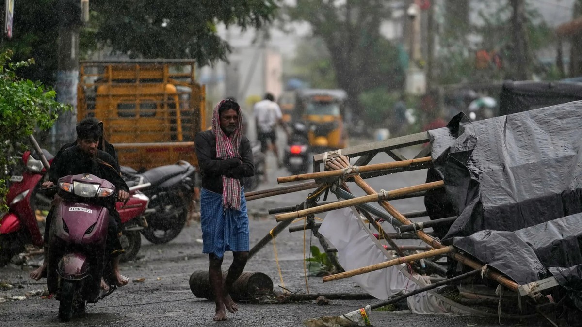
Cyclone Arnab crossed the Andhra Pradesh–Yanam coast between 2 am and 8 am on Wednesday 28 October as a very severe cyclonic storm, the third-highest category on the India Meteorological Department's scale, New Indian Express reported. It weakened to a severe cyclonic storm around 8.30 am. Maximum sustained winds were 125–135 kmph, easing to 110–120 kmph after weakening, with a storm surge forecast up to 1.5 metres above tide level.
Odisha Chief Minister Mohan Charan Majhi said the cyclone hit the Andhra coast much earlier than expected, around 2 am rather than Wednesday forenoon. "Our early preparations and evacuation saved many lives," he said, according to New Indian Express. Two days later, on Friday 30 October, rain under the system's influence triggered a landslide at Gidipabali, a hilltop hamlet in Ganjam district. The meteorological department now forecasts a second system, with landfall expected Tuesday morning.
What the Forecast Actually Says
The system originated as a low-pressure area over the South Andaman Sea on 29 October and intensified into a depression over the southeast Bay of Bengal on Saturday, the India Meteorological Department said. At 05:30 IST Saturday it lay about 960 km east-southeast of Chennai and 980 km southeast of Visakhapatnam, having moved west-northwestwards at about 30 kmph over the previous six hours, Deccan Chronicle reported, quoting the Amaravati bulletin.
A bulletin issued at 20:30 IST Saturday said the deep depression "will turn into a cyclonic storm on November 1 and severe cyclonic storm over west central Bay of Bengal on November 2." The department said the system is "very likely to reach the south Andhra Pradesh coast by early hours of Tuesday, November 3, and cross south AP coast as a severe cyclonic storm with wind speed of 100 kmph to 110 kmph, gusting to 120 kmph, between Nellore and Narsapur by Tuesday morning."
The Number That Will Not Sit Still
There is no settled death toll from Cyclone Arnab, and the figures reported by different sources do not agree. NDRF Inspector General Narendra Singh Bundela said on landfall day that three people had been killed, 31 houses damaged and trees uprooted, with Andhra Pradesh worst affected. Andhra Pradesh Chief Minister N Chandrababu Naidu said that evening that five people had died — three in Visakhapatnam district from falling electric poles and trees, one in Anakapalli and one in Bhimavaram. "Despite many efforts, five people died today," he said, according to Hindustan Times.
Reuters reported the next day that the official toll was six, citing a state government official. The Times of India, citing local officials, put the toll at nine, caused by electrocution as well as tree and house collapses. In Odisha, Special Relief Commissioner Rajesh Prabhakar Patil reported four dead and twelve missing in landslides and rain-related incidents across Ganjam, Gajapati and Kandhamal districts as of Saturday.
Twelve Still Unaccounted For at Gidipabali
The landslide struck Gidipabali, a hilltop hamlet under Bhanjanagar block in Ganjam district on the Ganjam–Kandhamal border, on Friday 30 October. Patil said the hamlet had a total population of 26, of whom 13 were relocated following heavy rainfall. "After the landslide struck the hamlet, we received reports that 13 people were still missing. So far, one person has been rescued alive and taken to a relief shelter. A full-fledged rescue operation is still underway to trace the remaining missing persons," he told Indian Express.
More than 170 personnel from the NDRF, the Odisha Disaster Rapid Action Force, fire services and the Special Operation Group of Odisha Police were engaged in the search, which had been under way since Friday night. Survivor Soudamini Mallik said some of her relatives were still missing and appealed to the administration to save them. "All those who survived had sustained injuries after being hit by the stones," she told India Today.

Forty Thousand People Are Still in Relief Camps
Nearly 40,000 people remained in 367 relief camps across Ganjam district on Saturday, Indian Express reported, with more than 105,000 people affected by floods in Ganjam and over 25,000 in neighbouring Gajapati. Odisha Disaster Management Minister Suresh Pujari said 313 rescue teams had been deployed across the state, with more than 100 working in Ganjam and Gajapati districts, according to The Logical Indian.
Four helicopters of the Indian Navy and the Indian Coast Guard were deployed to airdrop food packets in flood-hit Ganjam. The state government announced an ex gratia of Rs 4 lakh each for the families of the dead and sanctioned an additional Rs 20 crore for Ganjam district, NDTV reported. Patil said the Rushikulya river had fallen below the danger mark and floodwaters were receding in several inundated villages, with electricity restored in 80 per cent of affected areas.
The Four Thousand Seven Hundred Crore Question
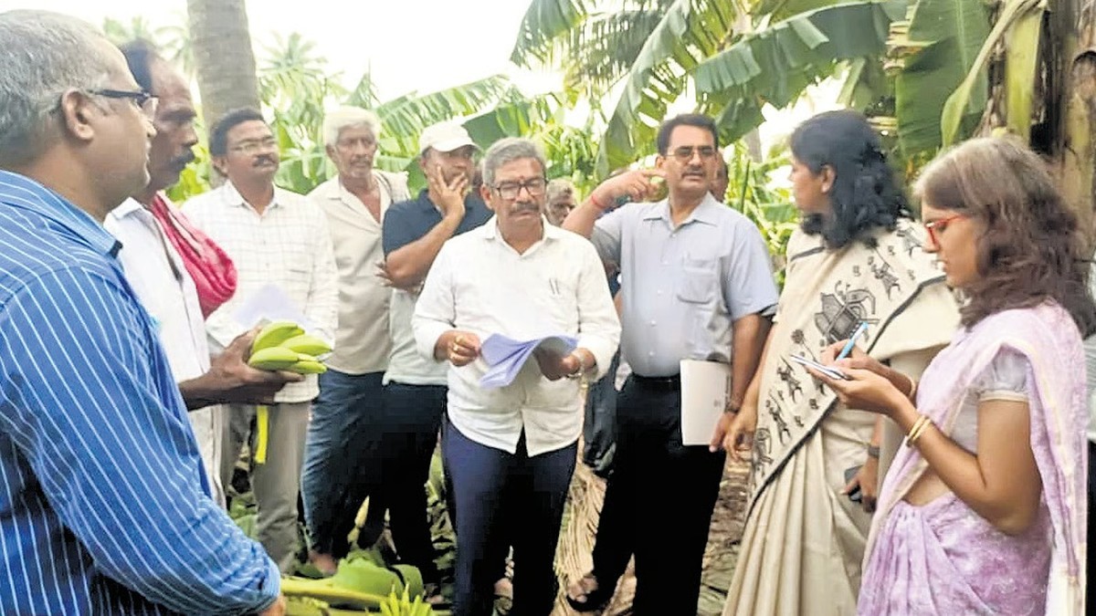
A seven-member Central Government assessment team led by Chittaranjan Dash, Joint Secretary in the Ministry of Home Affairs, visited the Real Time Governance Society Centre at the Secretariat in Vijayawada on Saturday to assess the damage caused by Cyclone Arnab. The preliminary assessment put the damage in Andhra Pradesh at Rs 4,764 crore, New Indian Express reported.
The cyclone damaged crops belonging to 463,000 farmers across 352,000 hectares and horticultural crops across 23,383 hectares, according to the assessment. It damaged 2,491 km of state roads and affected 7,382 houses, with twelve districts reporting cyclone damage and Konaseema and West Godavari among the worst affected. Dash said the team would make efforts to ensure Andhra Pradesh received adequate assistance from the Centre and would recommend immediate assistance. A separate central team was due in Odisha on 2 November to assess that state's damage, the Disaster Management Minister said.
What Andhra Built Before the First Storm
Andhra Pradesh alerted the public about Cyclone Arnab six days in advance through the Real Time Governance Society and the Andhra Pradesh State Disaster Management Authority, sending cyclone-related alerts to 72.3 million mobile users, RTGS Secretary Katamneni Bhaskar said. Authorities established 3,455 control rooms at district and mandal levels and appointed 3,918 nodal officers. The state identified 2,199 cyclone shelters across 20 districts and shifted 34,716 people into them.
Sixteen NDRF and eleven SDRF teams were deployed across 14 districts, with 1,355 ambulances ready and 3,012 pregnant women shifted to hospitals as a precaution. Some 30,043 fishing boats were kept within harbours. During landfall, authorities prevented people from leaving their homes and stopped vehicular movement on roads. Dash praised the Mana Mitra WhatsApp governance channel, through which officials said more than 95 per cent of cyclone-related complaints were resolved. "All states need to follow this approach," he said.
Why the Bay Is Doing This Twice
IMD Director General Mrutyunjay Mohapatra attributed the back-to-back cyclones to the Madden-Julian Oscillation. "The Madden-Julian Oscillation is very active and in phase 3. It is near the Bay of Bengal and is helping the genesis of two cyclones one after the other. Along with the MJO, the equatorial Rossby wave is also favourable. When these waves work together over the same area, cyclogenesis becomes favourable," he told the Times of India.
India usually records four to five cyclones annually, with three to four during the October–December post-monsoon season and one to two during the pre-monsoon period from April to June. There were no cyclones during either the pre-monsoon or monsoon season in 2026; Arnab was the first and the new system would be the second. Mohapatra attributed the below-normal activity partly to strong El Niño conditions, which tend to reduce cyclone numbers over the Bay of Bengal and the Arabian Sea.
The Storm Named Drum
If it develops as forecast it will be named Murasu, Mohapatra said, making it the second cyclone of the year after Arnab. Names for Bay of Bengal and Arabian Sea cyclones are assigned by the World Meteorological Organization and the UN Economic and Social Commission for Asia and the Pacific Panel on Tropical Cyclones, the Times of India reported. The naming system began in 2004 and the list was expanded as more countries joined.
Murasu was contributed by India and means "drum" in Tamil, an ancient percussion instrument used to disseminate information and warn people about natural disasters. The Times of India noted it was probably the first time since 2004 that a tropical cyclone over the north Indian Ocean would have a Tamil name. Arnab, contributed by Bangladesh and pronounced "Ornab", means ocean in Bengali. Names already used from the regional list include Nisarga, Biparjoy, Arnab and Upakul.
What Tuesday Morning Will Tell Us
Mohapatra said the system is expected to cross the south Andhra Pradesh coast on 3 November, but the exact landfall location could not yet be determined because it was still several days from the coast. Forecasts differ on where it will come ashore: the meteorological department's bulletin gives the stretch between Nellore and Narsapur, while Mathrubhumi reported the storm was expected to cross near Machilipatnam. A Kolkata Regional Met Centre bulletin quoted by the Times of India said it would hit land somewhere between Chennai and Vijayawada.
IMD Bhubaneswar director Manorama Mohanty said Odisha could face a relatively lesser impact because the projected path lies further south, though authorities fear fresh rain could hamper relief and repair work. The department issued an orange warning for heavy to very heavy rain in Gajapati, Ganjam, Rayagada, Koraput and Malkangiri on Tuesday. Mohapatra said very heavy rainfall could reach 200–300mm at some places in Andhra Pradesh and south Odisha.
By Jessica Ali, Staff Writer
This article was produced with AI-assisted research and editorial support. Photographs: Mahesh Kumar A/AP via Al Jazeera; ANI via The Hindu; EPS via The New Indian Express. Cover: Global 1 News editorial image. Sources: India Meteorological Department, Times of India, India Today, Hindustan Times, The Hindu, New Indian Express, Indian Express, Deccan Chronicle, Mathrubhumi, NDTV, National Herald, Reuters, Al Jazeera.
What's Your Reaction?
 Like
0
 Dislike
0
 Love
0
 Funny
0
 Wow
0
 Sad
0
 Angry
0

Editor-in-Chief at Global1.News. Atlanta-based journalist who cuts through the BS and tells it like it is. Lead anchor, host, and the voice you hear when the spin stops and the truth starts.















Comments (0)