
San Andreas Fault Slip Rate Faster Than Thought, Study Finds
New San Jose State research finds the San Andreas Fault is slipping faster than previously thought, with a slip rate that has held constant for 10,000 years. As California shakes through an active August, the study's message is clear: prepare now, not later.
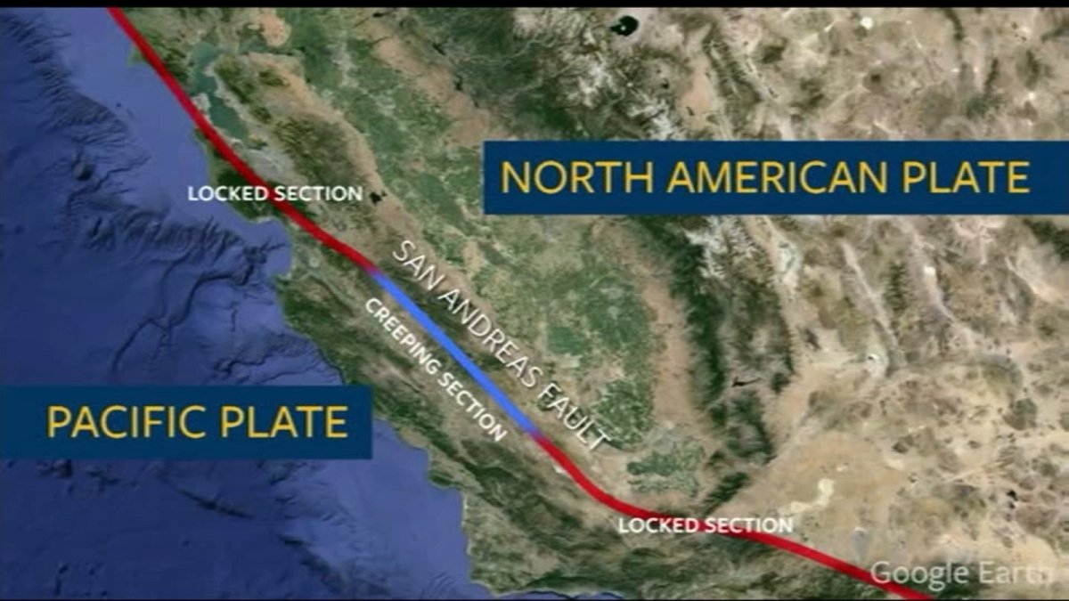
The ground beneath California has been talking all month — a rumble here, a jolt there, a swarm of shakers down south. And now, just as those tremors have the Golden State’s attention, a team of researchers out of San Jose State University has dropped a finding that changes the conversation entirely. The San Andreas Fault — that 800-mile scar running the length of California — is slipping faster than we thought. Not a little faster. A lot faster. And it’s been doing it for roughly ten thousand years.
San Andreas Fault Slip Rate Faster Than Thought, Study Finds
San Francisco, CA — Folks, let me be straight with you. This is not a panic piece. This is a preparedness piece. But it starts with a fact that should make every Californian — and honestly, every American who understands how the West Coast works — sit up and pay attention. New research from San Jose State University has found that the San Andreas Fault is moving at a rate that defies previous assumptions. And that movement has been constant for the last 10,000 years. Not slowing. Not pausing. Constant.
This comes on the heels of a notably active August — a 3.8 shaker near Oakland, a 3.9 near Pinnacles, a swarm at the Coso Volcanic Field. The ground is restless. And now, science is telling us why we should have been paying closer attention all along.
The Research: What San Jose State University Found
Let’s get into the weeds, because this matters. Professor Kim Blisniuk, a geology professor at San Jose State University, has been working with her students at Sanborn County Park in Saratoga, California — in the Santa Cruz Mountains section of the fault, just south of the Bay Area. What they found there is turning heads in the geology community.
The fault’s movement rate — the speed at which the two sides of the fault are grinding past each other — has stayed constant over a roughly 10,000-year window. That’s the headline. Prior to this work, the assumption was that the slip rate in this section of the fault decreased over time. Blisniuk and her team found the opposite. The rate is not decreasing. It’s holding steady.
And here’s the kicker: that rate is similar to the rate measured much farther north, along the fault’s north coast section. The fault isn’t slowing down as it moves south. It’s keeping pace. And that changes the risk calculus.
Why a Faster Slip Rate Means More Frequent Earthquakes
Now, let’s talk about why this matters. Faults that move faster can generally produce earthquakes more frequently. It’s like a rubber band being stretched — the faster you pull, the sooner it snaps. A fault being pulled at a constant rate means the potential for seismic events along this section is higher than previously estimated.
Blisniuk put it this way in an interview with ABC7 Eyewitness News: “And so the great aspect of this work is that it is a rate of which the landform preserves previous earthquakes along the fault. And the rate is similar to the rate that we get for the San Andreas Fault to the north in the north coast section. But prior to the work that my colleagues and I did at Sanborn County Park, the rate appears to not decrease along the San Andreas Fault, but it appears to be constant over this 10,000-year window that we were able to document.”
Let me translate that. The land itself — the creeks, the ridges, the displaced rock — is a record of past earthquakes. By measuring how that land has deformed over thousands of years, Blisniuk and her students have essentially read the fault’s diary. The entry for the last ten millennia reads: steady, constant, unrelenting movement.
The Context: A Busy August on California’s Faults
This research is landing at a moment when California’s fault systems are already making headlines. On August 13, 2026, a magnitude 3.8 earthquake — some reports say 3.9 — shook the San Francisco Bay Area at about 8:30 in the morning. The epicenter was just north of the Oakland Zoo, sitting right on the Hayward Fault, about two miles north of San Leandro. It was widely felt across the Bay Area and as far away as Sacramento. The ShakeAlert Earthquake Early Warning System was activated. No major damage was reported, but folks felt it.
Two days earlier, on August 11, a magnitude 3.9 shallow earthquake struck about 6 kilometers northwest of Pinnacles, California. That one was shallow — only about 4.6 kilometers deep — and it was felt by more than 30 people, with a maximum intensity of MMI 4.5. That quake was on the central San Andreas Fault zone. And it wasn’t alone. The Sacramento Bee reported eight tremors of magnitude 2.5 or above in the prior week near Pinnacles, with the largest being a 3.3 on August 7. Social and news accounts reported at least 19 quakes in that swarm.
And just this week, on August 21, a swarm shook the Coso Volcanic Field in Inyo County. That activity isn’t unusual — the region has seen swarms before, often distant aftershocks from larger quakes nearby. But it all adds up to a picture of a state that is geologically alive and kicking.
What This Means for the Big One
Here’s where I need to be careful — there’s a fine line between responsible reporting and fear-mongering. I’m not going to cross it. But I am going to give you the facts.
The San Andreas Fault runs roughly 800 miles through California, from the Salton Sea to Cape Mendocino. It produced the 1906 San Francisco earthquake — the one that literally reshaped the city — and the 1989 Loma Prieta earthquake, a magnitude 6.9 that caused widespread damage and 63 deaths. The southern section hasn’t ruptured since 1857, when the Fort Tejon quake struck. That’s a long time — and geologists have been watching that section with increasing concern.
Earlier this year, in June 2026, a separate study led by earth scientists at the University of Hawai’i at Manoa, published in the Journal of Geophysical Research: Solid Earth, found that tectonic stress along the southern San Andreas and San Jacinto fault systems has reached — and in some places exceeded — the highest levels seen in the past 1,000 years. The researchers built a physics-based computer model simulating how stress builds and releases along those systems, including at Cajon Pass, a critical junction between the two.
Put those two studies together — constant slip rates on the central section and record-high stress on the southern section — and you have a picture of a fault system that is loaded and moving. Blisniuk acknowledged this when she told ABC7: “We know that we live on a plate boundary, and we are always surprised when we hear, ‘Oh my gosh, an earthquake occurred in Japan or Colombia,’ but we are going to have an earthquake in California, and we should be prepared. I don’t think the idea that the slip rates are constant along the San Andreas Fault, where we have studied, is a big surprise to a lot of people. We just didn’t have that data before.”
The Caveat: This Research Is Not Yet Peer-Reviewed
Now, I have to be honest about where this research stands. It has not yet been published or peer-reviewed — the U.S. Geological Survey declined to comment because it remains unpublished, and Blisniuk plans to present the data at a conference in October. That’s standard practice in science: you present, you get feedback, you revise, you publish. It also means we should treat this as significant but preliminary.
That said, the data is what it is. Blisniuk and her students have documented a constant slip rate over a 10,000-year window. That’s not a guess. That’s measurement — and it aligns with a broader understanding that the San Andreas Fault is one of the most active and dangerous fault systems in the world.
Blisniuk also reminded us of the historical record: “So we do have historical earthquakes along this fault, and we will have them in the future.” That’s not speculation. That’s geology. The fault has produced major earthquakes before. It will again. The only question is when.
What You Can Do: Preparedness, Not Panic
Here’s the part where I get to talk directly to you, because this is where the story matters most. Blisniuk’s message is preparedness, not panic. She used an analogy that I want you to remember: insurance.
“I always use the example of insurance,” she told ABC7. “We always want auto insurance. We buy auto insurance, home insurance. We never want to use it, but it’s there for us. And so, having an earthquake preparedness kit to prepare us for a potential disaster when an earthquake occurs will really help us deal with the trauma of having an earthquake.”
Folks, that’s the takeaway. You don’t buy insurance because you want to crash your car. You buy it because you might. And you build an earthquake kit for the same reason — not because you’re scared. Because you’re smart.
So here’s what you do. Get a kit: water — at least a gallon per person per day for three days — non-perishable food, a flashlight, batteries, a first-aid kit, medications, cash, copies of important documents, a whistle, dust masks. And make a plan: know where you’ll meet your family, how you’ll communicate, the safe spots in your home. Drop, cover, and hold on. That’s the drill. Practice it.
And know your fault — literally. Find out if you live near a fault line. The USGS has maps, and your local emergency management office has resources. California has some of the best earthquake preparedness infrastructure in the world — ShakeAlert, early warning apps, building codes that save lives. Use them.
The Bottom Line: The Ground Is Moving, and So Should You
Here’s the bottom line, plain. The San Andreas Fault is slipping faster than we thought. It has been for 10,000 years. It’s not slowing down — and the potential for earthquakes along this fault is real, present, and ongoing. The research from San Jose State University is a wake-up call: not a siren, but a firm hand on the shoulder.
Blisniuk and her students have given us data — a clearer picture of the ground we stand on. They’ve reminded us that we live on a plate boundary, a place where the Earth’s crust is constantly moving, constantly building stress.
But we can be prepared. That’s the message. That’s the action. That’s the way forward.
So make the kit. Know the plan. Stay informed. When the ground shakes — and someday, it will — you’ll be ready.
Stay safe, folks. Stay ready. And stay tuned.
This article was produced with AI-assisted research and editorial support. Sources: ABC7 Eyewitness News, SF Chronicle, NY Post, USGS, University of Hawai’i at Manoa.
By Jessica Ali, Staff Writer
What's Your Reaction?
 Like
0
Like
0
 Dislike
0
Dislike
0
 Love
0
Love
0
 Funny
0
Funny
0
 Wow
0
Wow
0
 Sad
0
Sad
0
 Angry
0
Angry
0

Editor-in-Chief at Global1.News. Atlanta-based journalist who cuts through the BS and tells it like it is. Lead anchor, host, and the voice you hear when the spin stops and the truth starts.













Comments (0)