
‘Queenie’ strengthens as it nears PAR exit
Typhoon Queenie, known internationally as Surigae, has begun a modest intensification as it speeds north‑northeastward, according to the latest bulletin from the Philippine Atmospheric, Geophysical and Astronomical Services Administration (PAGASA).
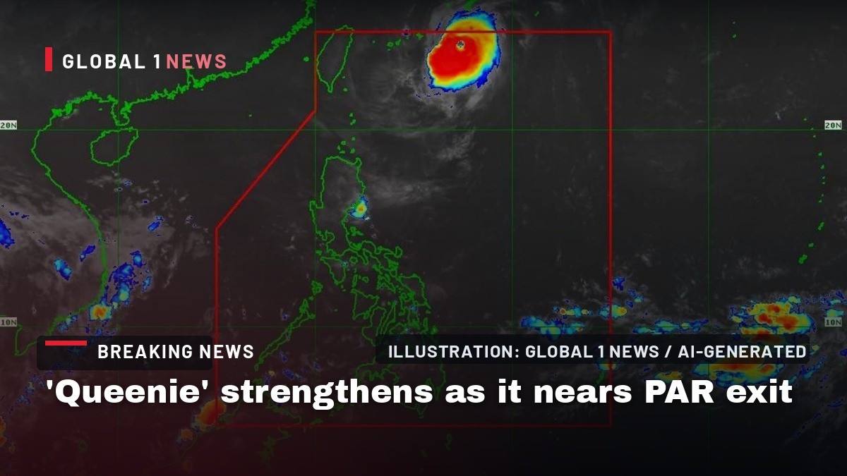
Typhoon Queenie, known internationally as Surigae, has begun a modest intensification as it speeds north‑northeastward, according to the latest bulletin from the Philippine Atmospheric, Geophysical and Astronomical Services Administration (PAGASA). While the storm remains a concern for the northernmost islands, its trajectory suggests an exit from the Philippine Area of Responsibility (PAR) later today, offering a brief window of relief for communities still reeling from recent weather disturbances.
Current Strength and Wind Field
PAGASA’s 5 a.m. bulletin reported that Queenie is now carrying maximum sustained winds of 130 kilometers per hour near its center, with gusts reaching up to 160 kph. These figures place the typhoon just below the threshold for a Category 2 system on the Saffir‑Simpson scale, but the wind field remains extensive. Strong to storm‑force winds are expected to extend outward up to 300 kilometers from the center, meaning that even barangays far from the eye will feel the brunt of the gale.
For fishermen and coastal commuters, the wind intensity translates into hazardous conditions on the water. Motorbancas and similarly sized vessels have been urged to take precautionary measures, and, if possible, to avoid navigating under these conditions. The advisory underscores the importance of local maritime safety protocols, especially for those who depend on daily trips to nearby islands for livelihood.
Location and Movement
At 4 a.m. Sunday, the center of Queenie was estimated to be about 685 kilometers northeast of Itbayat, the northernmost municipality of Batanes. From that point, the storm is projected to move generally northeastward over the forecast period, a path that will keep it over open water for most of its remaining life cycle. PAGASA expects the system to exit the Philippine Area of Responsibility between noon and the afternoon on Sunday, a timeline that aligns with the agency’s standard monitoring windows for tropical cyclones.
Once outside the PAR, Queenie will accelerate further toward the sea south of mainland Japan, a trajectory that mirrors the classic “recurving” pattern of many Pacific typhoons. This movement will carry the storm into the vicinity of the Okinawa Islands, where it is forecast to intensify further before eventually weakening by Monday, September 28.
Sea Conditions and Coastal Impact
In addition to wind, sea state is a critical factor for coastal communities. PAGASA warned of moderate seas up to two meters along the northern seaboard of Batanes within the next 24 hours. While wave heights of less than two meters are expected in other coastal waters, the combination of wind and swell can still pose risks to small fishing boats and to residents near the shoreline.
Local barangay disaster risk reduction and management offices have been mobilizing resources to monitor tide levels and to assist any residents who may need to evacuate low‑lying areas. The advisory to mariners reflects a broader effort to prevent accidents at sea, a concern that resonates deeply in a nation where many families depend on the ocean for their daily bread.
Potential Intensification Beyond the PAR
Although Queenie is expected to leave Philippine jurisdiction later today, PAGASA notes that the storm will likely intensify further as it moves over the warm waters south of the Okinawa Islands. Sea surface temperatures in that region remain conducive to strengthening, and the forecast calls for Queenie to reach its peak intensity before beginning a gradual weakening phase.
This anticipated intensification underscores the interconnected nature of regional weather systems. While the Philippines may soon be out of the storm’s direct path, the broader Pacific community will continue to monitor Queenie’s evolution, especially as it approaches other vulnerable island chains and shipping lanes.
Community Preparedness and Response
In the barangays of Batanes, the announcement of Queenie’s approach has triggered a familiar cycle of preparedness. Local officials have coordinated with the Department of the Interior and Local Government to ensure that evacuation centers are ready, that relief supplies are stocked, and that communication lines remain open. Residents have been reminded to secure loose items, reinforce roof trusses, and keep emergency kits—often stored in the corner of a sari‑sari store—within easy reach.
The communal spirit of bayanihan shines brightest during such times. Neighbors help each other board up windows, share generators, and check on the elderly and children. Even as the storm moves farther north, the collective vigilance of these coastal communities remains a vital line of defense against the potential damage of high winds and rain.
Looking Ahead: Forecast Beyond Monday
After reaching its peak intensity south of Okinawa, Queenie is expected to begin weakening by Monday, September 28. The weakening trend will be driven by cooler sea surface temperatures and increasing wind shear as the system moves into higher latitudes. While the exact timing of the decline cannot be pinpointed, the forecast suggests a gradual loss of strength rather than an abrupt dissipation.
For the Philippines, the immediate concern is to ensure that any residual effects—such as heavy rainfall or isolated gusts—do not catch communities off guard. The Department of Health, for instance, stands ready to respond to any flood‑related health emergencies, while the Office of the Ombudsman continues to monitor the use of disaster funds to guarantee transparency and accountability.
Regional Implications and International Monitoring
Typhoon Queenie’s journey is not just a national story; it is part of a larger pattern of tropical activity in the western Pacific. As the storm accelerates toward the sea south of mainland Japan, neighboring countries and international agencies will keep a close watch. The Japan Meteorological Agency, for example, will likely issue its own advisories as Queenie approaches the Okinawa Islands, and shipping companies will adjust routes to avoid the storm’s projected path.
For Filipino OFWs and overseas families, the news of Queenie’s exit from the PAR offers a moment of relief, yet it also serves as a reminder of the ever‑present risk of typhoons that can affect families back home. The shared experience of weather alerts, community drills, and the collective hope for safety ties the diaspora to the archipelago, reinforcing the enduring connection between Filipinos wherever they may be.
This article was produced with AI-assisted research and editorial support. Reporting is based on the source material cited below. Sources: Philstar.com; Global1.News (27 September 2026).
By Bella Reyes, Staff Writer
What's Your Reaction?
 Like
0
Like
0
 Dislike
0
Dislike
0
 Love
0
Love
0
 Funny
0
Funny
0
 Wow
0
Wow
0
 Sad
0
Sad
0
 Angry
0
Angry
0

Philippines/Southeast Asia Correspondent at Global1.News. Manila-based journalist covering Philippine politics, environment, maritime security, and social issues. Passionate about marine conservation and the communities protecting the Philippines' natural heritage.













Comments (0)