
Glacial Collapse and a Wall of Mud: The Nepal-Tibet Border Disaster and the Geopolitics of a Shifting Himalaya
The catastrophic flooding that obliterated communities along the Nepal-Tibet border on Wednesday, 26 August 2026, has evolved from a singular natural disaster into a complex, multi-layered crisis involving glacial science, transboundary river management, and a delicate diplomatic dance between.
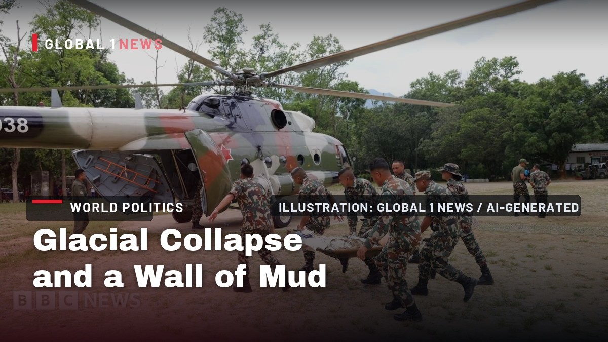
The catastrophic flooding that obliterated communities along the Nepal-Tibet border on Wednesday, 26 August 2026, has evolved from a singular natural disaster into a complex, multi-layered crisis involving glacial science, transboundary river management, and a delicate diplomatic dance between Kathmandu and Beijing. As rescue operations remain suspended due to the imminent threat of a secondary flood, the region is confronting a humanitarian catastrophe of staggering proportions while simultaneously navigating the geopolitical fault lines of a rapidly warming Hindu Kush Himalaya.
The Timeline of a Catastrophe
The disaster struck with terrifying speed on the morning of 26 August. A deluge of mud, rock, and water careered down the Bhote Koshi gorge, sweeping away buildings, roads, and vehicles in the Rasuwa and Nuwakot districts of Nepal, and simultaneously inundating the Gyirong Port area on the Tibetan side of the border. Footage from the scene showed a towering wall of water and debris enveloping the Rasuwagadhi border checkpoint, a multi-storey structure, as people fled for their lives. The initial assumption was that an earthquake had triggered a landslide, but the US Geological Survey (USGS) has since clarified the cause: a "glacial collapse." The impact of the collapsing glacier hitting the valley floor was so immense that it registered a magnitude of 5.2 on seismic instruments. The subsequent debris flow, as the USGS noted, "caused subsequent catastrophic impacts downstream." The event has unleashed a humanitarian emergency, with Nepali police reporting at least 475 deaths as of Friday morning, and 910 people still missing, according to Nepal's National Disaster Risk Reduction and Management Authority. The Nepal Tourism Board has confirmed that 644 of the missing are foreign tourists, including 33 UK nationals. On the Tibetan side, China's state broadcaster CCTV reported that the number of missing in Gyirong county had risen to 558, including 260 foreign nationals, with a confirmed death toll of three.The Science of a Glacial Collapse
The scientific community is now working to piece together the exact sequence of events that led to this catastrophe. Geologist Daniel Shugar of the University of Calgary was among the first to suggest glacial activity as the cause. He explains that glacial thinning, induced by global warming, can increase the risk of landslides, though he cautions that it is too early to definitively link this specific event to climate change. Simon Cook, a geoscientist at the University of Dundee, has identified the likely origin: the lower part of a glacier near the Langtang Lirung peak, approximately 15 kilometers west of the flood site. The glacier collapsed in a north-westerly direction before travelling westwards downstream. Cook highlights a critical, often-overlooked factor: "Permafrost is partially holding some mountainsides together; this permafrost is warming and thawing and degrading so you are going to get more landslides." This suggests a dual threat where both ice and the very ground itself are becoming less stable. Mike Searle, professor of Earth sciences at Oxford University, offers a compelling hypothesis for the chain reaction. He posits that the glacier may have collapsed "hours or days" before the main flooding event. "I think the sheer wave of debris suggests there was a landslide first, the water built up, (which) dammed the river, and then it burst in one huge great flood." This theory points to a two-stage disaster: an initial collapse creating a natural dam, followed by a catastrophic breach. Scientists are now analyzing satellite imagery to determine where the river became blocked, whether glacial lakes drained suddenly, and to correlate the event with recent rainfall data.The Human Toll and the Suspension of Rescue
The human cost of this disaster is staggering and continues to climb. The confirmed death toll of 475 in Nepal includes 64 people found in downstream Chitwan district and 26 in Nawalparasi East, illustrating the immense reach of the floodwaters. The list of 910 missing is a roll call of tragedy, including 517 foreign citizens, 44 members of the Nepali army, and 28 police officers. The 644 missing tourists represent a global tragedy, with India reporting 290 of its citizens untraceable. The rescue effort, however, has been brought to a standstill. A barrier lake formed by the initial mudslide has created a "high risk" of breaching, according to Chinese authorities. On Friday, the lake briefly overflowed, prompting China to suspend rescue operations in the Tibetan disaster zone. Nepal also halted its operations for 90 minutes following the breach. This secondary flood risk is a terrifying prospect. The International Centre for Integrated Mountain Development (ICIMOD) has warned that the Trishuli River may be temporarily blocked in narrow sections, and if this landslide dam fails, it could unleash a second, potentially more devastating wave of water and debris. David Fisher, head of the Red Cross delegation in Nepal, noted that these warnings have put people "very much on edge."The China-Nepal Transboundary Dimension
This disaster is not merely a shared tragedy; it is a stress test for the China-Nepal relationship. The epicenter of the destruction sits at the Gyirong Port crossing, a critical node in the China-Nepal economic corridor and a flagship project of Beijing's trans-Himalayan connectivity strategy. This port is the primary land link for trade between the two nations, and its destruction represents a significant strategic and economic setback. In this context, Beijing has moved swiftly to reject claims that it either failed to warn Nepal or that its infrastructure construction in Tibet triggered the floods. This defensive posture underscores the sensitivity of the issue. For Nepal, the disaster presents a dilemma. It is heavily reliant on Chinese investment and connectivity, yet it must also manage domestic public anger and ensure that Beijing is transparent about transboundary river data and early warning systems. The fact that the barrier lake is located several kilometers upstream from Gyirong Port, in the same region as the collapsed glacier, places the responsibility for monitoring and warning squarely on Chinese authorities. The brief suspension of Nepali rescue operations due to the lake's breach highlights the acute dependency of downstream nations on upstream actions.Regional and Geopolitical Implications
The implications of this disaster extend far beyond the immediate border region. For India, the 290 missing citizens represent a direct national tragedy. More strategically, the flooding of the Bhote Koshi and Trishuli rivers, which are tributaries of the Ganges, raises critical questions about transboundary water management in South Asia. While this event was a sudden, glacial-related catastrophe rather than a seasonal monsoon flood, it underscores the vulnerability of the entire Himalayan watershed. New Delhi will be watching closely to see how China and Nepal manage the secondary flood risk and what protocols are established for future information sharing. This event also injects a new, urgent dimension into Himalayan climate diplomacy. The Hindu Kush Himalaya region is warming faster than the global average, and this disaster serves as a stark, violent illustration of the consequences. The scientific debate—whether this specific collapse is definitively climate-induced—is a nuance that will be lost in the geopolitical arena. For nations like Nepal and India, this is a clear signal of the acute risks posed by a warming planet. It strengthens their argument for greater international cooperation and funding for climate adaptation and resilience, while also placing pressure on China, as the upstream power, to take a leading role in regional early warning systems and data transparency.What Happens Next: The Second Flood and the Long Recovery
The immediate priority is the barrier lake. The risk of a second, catastrophic flood is real and imminent. The suspension of rescue operations, while necessary for safety, is a painful decision for the families of the missing. The focus must now be on controlled drainage or breaching of the dam to prevent a larger catastrophe. This is a high-stakes engineering and logistical challenge in a remote, high-altitude environment. Once the immediate threat is mitigated, the long and arduous recovery will begin. The destruction of the Gyirong Port and the road networks on both sides of the border will cripple trade and connectivity for months, if not years. The economic corridor, a cornerstone of Nepal's development strategy, has been dealt a severe blow. Rebuilding will require immense investment and close cooperation between Kathmandu and Beijing. The disaster has also created a massive humanitarian need, with thousands displaced and in need of shelter, food, and medical care.Strategic Implications for Beijing and the Region
For Beijing, this disaster is a strategic test on multiple fronts. Domestically, it must manage the response in Tibet and ensure the safety of its citizens and the many foreign nationals within its borders. Internationally, it must balance its narrative of being a responsible regional power with the reality of being the upstream state. Its rejection of claims of negligence is a clear signal that it will not accept blame, but its actions in the coming days—particularly regarding data sharing and the management of the barrier lake—will be scrutinized as a measure of its true commitment to regional stability. The Nepal-Tibet flood is a brutal reminder that the "Belt and Road" infrastructure projects in the Himalayas are being built in one of the most geologically volatile and climate-sensitive regions on Earth. The strategic calculus has shifted. It is no longer just about the cost of building a road or a port; it is about the cost of maintaining it against the forces of a changing climate. For Nepal, the disaster underscores its profound vulnerability, caught between the geopolitical ambitions of its giant neighbors and the unforgiving power of nature. The path forward requires not just concrete and steel, but a new framework of transboundary cooperation, scientific transparency, and climate resilience that has, until now, been sorely lacking.By Prof. Marcus Chen, Staff Writer
This article was produced with AI-assisted research and editorial support. Sources: BBC News, France 24, Reuters/Guardian wire reports, India Today, ICIMOD, USGS.
What's Your Reaction?
 Like
0
Like
0
 Dislike
0
Dislike
0
 Love
0
Love
0
 Funny
0
Funny
0
 Wow
0
Wow
0
 Sad
0
Sad
0
 Angry
0
Angry
0

Marcus Chen
World Politics Analyst at Global1.News. Based in Beijing, covering US-China relations, global trade, and geopolitical strategy. Brings deep analytical perspective to the power dynamics shaping international affairs.













Comments (0)