
Heavy to very heavy rainfall forecast for Telangana on September 23 and 24; red alert in eight districts on Wednesday
Heavy to very heavy rainfall is set to blanket much of Telangana over the next 48 hours, with the India Meteorological Department (IMD) issuing a series of red and orange alerts for Wednesday, 23 September, and Thursday, 24 September 2026.
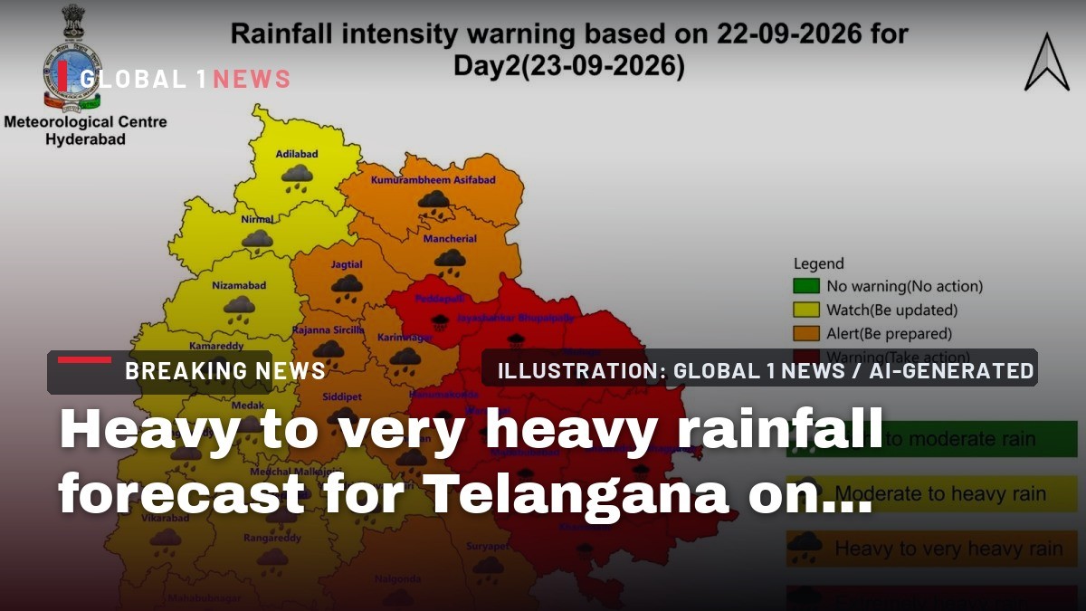
Heavy to very heavy rainfall is set to blanket much of Telangana over the next 48 hours, with the India Meteorological Department (IMD) issuing a series of red and orange alerts for Wednesday, 23 September, and Thursday, 24 September 2026. The system, a well‑marked depression over the west‑central Bay of Bengal, is expected to unleash sustained downpours across the state, prompting authorities to brace for flooding, disrupted transport and heightened demand for emergency services. As the clouds gather over Hyderabad and its surrounding districts, the situation offers a timely lens through which to examine the interplay of meteorological forecasting, disaster‑management policy, urban infrastructure, and the broader climate‑resilience agenda in India.
IMD’s Forecast and Alert Zones
The latest IMD bulletin flags a red alert for “very heavy to extremely heavy” rainfall in isolated pockets of eight districts: Peddapalli, Jayashankar Bhupalapally, Mulugu, Bhadradri Kothagudem, Khammam, Mahabubabad, Warangal and Hanumakonda on Wednesday. An orange alert—signalling “heavy to very heavy” rain—covers a broader set of districts, including Kumaram Bheem Asifabad, Mancherial, Jagtial, Rajanna Sircilla, Karimnagar, Nalgonda, Suryapet, Jangaon and Siddipet.
For Thursday, the red alert list expands to include Kumaram Bheem Asifabad, Mancherial, Karimnagar, Peddapalli, Jayashankar Bhupalapally, Mahabubabad, Warangal and Hanumakonda, while the orange alert now encompasses Adialabad, Nirmal, Nizamabad, Jagtial, Rajanna Sircilla, Khammam, Nalgonda, Suryapet, Jangaon and Siddipet. The repetition of several districts across both days underscores the persistence of the system and the heightened risk of cumulative rainfall impacts.
Rainfall Intensity and Expected Accumulation
Senior Meteorologist G.N.R.S Srinivas of the IMD Centre Hyderabad warned that “some districts in northern and northeastern Telangana could receive very heavy rainfall of 12 to 19 cm on Tuesday,” referring to the day preceding the alert period. While the bulletin does not quantify exact totals for Wednesday and Thursday, the phrasing suggests that the intensity will remain comparable, if not exceed, the earlier 12‑19 cm range.
In Hyderabad city itself, the forecast calls for “moderate to heavy rain or thundershowers accompanied with gusty winds,” with temperatures hovering around a maximum of 30 °C and a minimum of 22 °C. The combination of high humidity, saturated soils and gusty winds raises the likelihood of localized flooding, especially in low‑lying urban pockets and along the city's extensive drainage network.
Implications for Urban Infrastructure and Public Services
The impending deluge tests the resilience of Hyderabad’s storm‑water management systems, which have historically struggled during monsoon peaks. The city’s drainage capacity, much of which dates back to the 1970s, often faces bottlenecks in densely populated suburbs. With the forecast of “moderate to heavy rain” persisting over two consecutive days, the risk of waterlogging in commercial districts, residential colonies and arterial roads is pronounced.
Public services—particularly electricity distribution and public transport—are also vulnerable. Gusty winds can topple overhead lines, while water ingress may disrupt metro operations and bus depots. Emergency response teams are likely to be on heightened alert, coordinating with district disaster management authorities to pre‑position relief kits, sandbags and rescue equipment in the most exposed zones.
Disaster Management Framework and State Response
Telangana’s disaster‑management apparatus, anchored by the State Disaster Management Authority (SDMA), operates under the National Disaster Management Act of 2005. The issuance of red and orange alerts triggers a cascade of pre‑emptive actions: district disaster response teams are instructed to activate early warning systems, schools and public institutions may be advised to close, and relief camps are readied in anticipation of displacement.
Given that the red alert covers eight districts on Wednesday and expands to include additional districts on Thursday, the SDMA is expected to mobilise resources across a wide geographic spread. Coordination with the National Disaster Response Force (NDRF) and the Indian Armed Forces could be sought if floodwaters breach critical thresholds, a scenario that has unfolded in previous extreme weather events across the Deccan plateau.
Impact on Agriculture and Rural Livelihoods
Telangana’s agrarian belt, particularly in districts like Nalgonda, Mahabubabad and Warangal, relies heavily on rain‑fed agriculture. While a sudden surge of 12‑19 cm of rain can replenish soil moisture and benefit short‑duration crops, the intensity described as “very heavy to extremely heavy” raises concerns about runoff, soil erosion and crop damage. Fields lacking adequate contour bunding or protective cover may experience loss of topsoil, undermining yields for the upcoming rabi season.
Rural households, many of whom depend on daily wage labor, could face immediate disruptions. Flooded roads hamper market access, while water‑logged fields limit the ability of agricultural laborers to work. The state’s rural employment schemes, such as the Mahatma Gandhi National Rural Employment Guarantee Act (MGNREGA), may see a spike in demand for emergency works—road repairs, embankment strengthening and temporary shelters.
Climate Context and Long‑Term Resilience Planning
The current weather system is part of a broader pattern of increasingly erratic monsoon dynamics across the Indian subcontinent. Climate models project a rise in the frequency of intense precipitation events, especially over the peninsular interior where Telangana lies. This trend underscores the urgency of integrating climate‑resilient design into urban planning, agricultural practices and water‑resource management.
Telangana’s recent policy initiatives, such as the “Telangana Climate Resilience Mission,” aim to bolster flood‑early‑warning infrastructure, expand river‑basin level forecasting and promote climate‑smart agriculture. The red and orange alerts serve as a real‑time test of these measures, highlighting gaps—particularly in the dissemination of warnings to vulnerable communities and the capacity of local drainage systems to cope with extreme events.
Public Advisory and Safety Measures
Residents of the affected districts are urged to stay informed through official IMD bulletins, local news channels and district administration alerts. Precautionary steps include securing important documents, avoiding travel on low‑lying roads, and staying clear of riverbanks during peak rainfall hours. In Hyderabad, citizens should anticipate “moderate to heavy rain or thundershowers” and be prepared for sudden gusts that could affect outdoor activities.
Authorities have advised that schools and government offices in the most heavily impacted districts may operate on a reduced schedule or remain closed, depending on local conditions. Emergency helplines have been activated, and relief centres are being readied in anticipation of potential displacement. As the state navigates this two‑day deluge, the coordinated response of meteorological agencies, disaster‑management bodies and the public will be pivotal in mitigating loss of life and property.
This article was produced with AI-assisted research and editorial support. Reporting is based on the source material cited below. Sources: The Hindu; thehindu.com; Global1.News (23 September 2026).
By Dr. Raj Patel, Staff Writer
What's Your Reaction?
 Like
0
Like
0
 Dislike
0
Dislike
0
 Love
0
Love
0
 Funny
0
Funny
0
 Wow
0
Wow
0
 Sad
0
Sad
0
 Angry
0
Angry
0

India/South Asia Correspondent at Global1.News. Analytical voice with a background in science and health journalism. Based in New Delhi, covering Indian politics, education, healthcare, technology, and policy. Breaks down complex data into clear, actionable reporting.














Comments (0)