
Typhoon Obet Enters PAR, Nears Super Typhoon Strength
In an ANC 24/7 report aired Monday afternoon, PAGASA announced that a powerful typhoon had officially entered the Philippine Area of Responsibility and was given the local name Obet. The bulletin, which broke at 1:20 p.m., immediately put disaster preparedness agencies and residents of Northern Luzon on alert as the storm system showed signs of intensifying toward super typhoon strength while still far out at sea.
In an ANC 24/7 report aired Monday afternoon, PAGASA announced that a powerful typhoon had officially entered the Philippine Area of Responsibility and was given the local name Obet. The bulletin, which broke at 1:20 p.m., immediately put disaster preparedness agencies and residents of Northern Luzon on alert as the storm system showed signs of intensifying toward super typhoon strength while still far out at sea.
Typhoon Obet Enters PAR, Nears Super Typhoon Strength
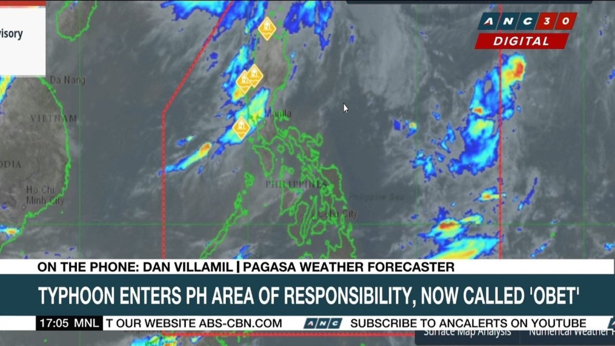
Manila, Philippines — Monday, August 24, 2026 — Typhoon Obet, known internationally as Saudel, entered the Philippine Area of Responsibility (PAR) at 1:20 p.m. Monday, and by 5:00 p.m., the Philippine Atmospheric, Geophysical and Astronomical Services Administration (PAGASA) had issued Tropical Cyclone Bulletin No. 1, confirming that the storm was moving west northwestward at 30 kilometers per hour with maximum sustained winds of 165 kilometers per hour near the center and gustiness reaching up to 205 kilometers per hour.

Typhoon Obet Enters the Philippine Area of Responsibility
PAGASA weather specialist Grace Castañeda-Carpio confirmed during the 5 p.m. press briefing that the eye of Typhoon Obet was estimated at 1,350 kilometers east-northeast of Extreme Northern Luzon, specifically at coordinates 24.6°N, 134.3°E. Just an hour earlier, at 3:00 p.m., the storm was positioned 1,375 kilometers away, showing a steady approach toward Philippine waters even as it remained far from land.
The entry of Obet into PAR marks the fourth tropical cyclone to affect the country in recent weeks, following the devastation wrought by Typhoons Luis and Maymay, and Tropical Depression Neneng. For many Filipino families still recovering from those storms, the news of another typhoon — even one expected to stay far from land — brings a familiar mix of anxiety and vigilance.
PAGASA has committed to issuing regular bulletins throughout the duration of Obet's presence in PAR, with the next updates expected to track any changes in intensity or direction. The agency's weather specialists emphasized that while the storm is currently powerful, its projected path suggests it will remain over the Philippine Sea and exit PAR by Monday night or in the early morning hours of Tuesday, August 25.
Near-Super Typhoon: Intensity and Forecast Track
Earlier Monday morning, PAGASA weather specialist Aldczar Aurelio reported that Saudel was nearing super typhoon category, with some readings indicating winds of 175 kilometers per hour and gusts reaching 215 kilometers per hour. The super typhoon threshold stands at 185 kilometers per hour, and Aurelio warned that the storm could reach that intensity while inside PAR.
By the 5 p.m. bulletin, the storm had slightly weakened to 165 kilometers per hour maximum sustained winds, but PAGASA maintained that fluctuations in intensity remain possible as the system interacts with favorable atmospheric conditions over the Philippine Sea. The storm's west northwestward movement at 30 kilometers per hour keeps it on a trajectory that, according to current projections, will not result in landfall anywhere in the Philippine archipelago.
No tropical cyclone wind signals have been raised, and PAGASA stated that Obet is likely to remain far from Philippine landmass throughout its passage. However, the agency cautioned that the storm's outer circulation and the enhanced Southwest Monsoon, or habagat, would still bring significant weather impacts to parts of Luzon in the coming days.
A Nation Already Weary: Habagat and Recent Cyclones
The arrival of Typhoon Obet comes at a time when the Philippines is still counting the cost of successive weather disturbances. The National Disaster Risk Reduction and Management Council (NDRRMC) reported as of 8:00 a.m. Monday that 2,035,185 families, or 6,988,279 individuals, have been affected by the combined effects of the Southwest Monsoon and tropical cyclones Luis, Maymay, and Neneng. The death toll stands at 29, with 17 injuries and 2 people still missing.
For communities in Ilocos, Cagayan Valley, and the Cordillera Administrative Region, the enhanced habagat has already brought flooding, landslides, and displacement. The additional rains expected from Obet's influence threaten to slow recovery efforts and put more pressure on already strained evacuation centers and relief operations.
PAGASA is also monitoring two other weather systems outside PAR: Tropical Storm Atsani, located 1,765 kilometers east of Central Luzon with winds of 65 kilometers per hour and gusts up to 80 kilometers per hour, and Tropical Depression Gaemari, formerly known as Neneng, positioned 505 kilometers north-northwest of Itbayat, Batanes, with winds of 45 kilometers per hour and gusts to 55 kilometers per hour. While neither system is currently expected to enter PAR, their presence adds complexity to the regional weather picture.
What the Weather Holds: Rains Across Luzon
For Tuesday, August 25, PAGASA forecasts cloudy skies with scattered rains and thunderstorms over Metro Manila, the Ilocos Region, the Cordillera Administrative Region, Cagayan Valley, Central Luzon, and the provinces of Cavite, Batangas, and Rizal. These conditions are attributed to the enhanced Southwest Monsoon being pulled by Typhoon Obet's circulation.
Western Visayas, the Negros Island Region, and the rest of Luzon can expect partly cloudy to cloudy skies with isolated rain showers or thunderstorms, while localized thunderstorms are possible elsewhere in the country. The enhanced habagat means that even areas far from the typhoon's direct path will experience wet weather, a pattern familiar to Filipinos who have endured weeks of monsoon rains.
Coastal waters over the northern and western sections of Luzon are forecast to be moderate to rough, posing risks to fisherfolk and small seacraft operators. PAGASA advised those planning maritime activities to monitor updates and exercise caution, particularly in areas where the enhanced monsoon and the typhoon's outer winds combine to create hazardous conditions.
Preparations and Public Response
Local government units in Northern Luzon, particularly in Batanes, Cagayan, and Ilocos provinces, have been placed on heightened alert even though no wind signals have been raised. The experience of recent weeks has taught many communities that a typhoon need not make landfall to cause disruption, especially when combined with an active monsoon season.
In Metro Manila, residents are bracing for another round of monsoon rains that could trigger flooding in low-lying areas such as Marikina, Tondo, and parts of Quezon City. Barangay officials in flood-prone communities are on standby, and many families have begun clearing drainage canals and preparing emergency kits — a routine that has become second nature after weeks of monsoon weather.
For farmers in Central Luzon and the Cagayan Valley, the continued rains pose a threat to standing crops and harvest schedules. Agricultural damage from the previous cyclones has already been significant, and additional rainfall could delay planting and recovery efforts, threatening the livelihoods of rice and corn farmers who are still assessing losses from recent storms.
What to Watch For
PAGASA will continue issuing Tropical Cyclone Bulletins as Typhoon Obet traverses the Philippine Sea. The key factors to monitor in the coming hours are whether the storm intensifies to super typhoon status, any shifts in its track that could bring it closer to land, and the behavior of the enhanced Southwest Monsoon that is already affecting large parts of Luzon.
The exit of Obet from PAR, expected Monday night or early Tuesday morning, does not signal an immediate end to the wet weather. The enhanced habagat is likely to persist for several more days, and the presence of Tropical Storm Atsani and Tropical Depression Gaemari in the region means that the Philippines remains in an active weather pattern.
For the millions of Filipinos who have endured weeks of storms, flooding, and displacement, the message from PAGASA is one of cautious optimism tempered by preparedness. Typhoon Obet may not make landfall, but its influence on the monsoon and the cumulative toll of the past month demand continued vigilance from every community, from the fisherfolk of Batanes to the commuters of Metro Manila.
As the nation watches the storm's progress, the resilience that has defined the Filipino response to countless typhoons remains evident. Neighbors are checking on neighbors, barangay captains are coordinating with disaster offices, and families are securing their homes against the rains to come. The storm will pass, as they always do, but the preparation and unity of the Filipino people are what carry the nation through each weather event, no matter how strong the winds or how heavy the rain.
By Bella Reyes, Staff Writer
This article was produced with AI-assisted research and editorial support. Reporting is based on sources cited in the article.
What's Your Reaction?
 Like
0
Like
0
 Dislike
0
Dislike
0
 Love
0
Love
0
 Funny
0
Funny
0
 Wow
0
Wow
0
 Sad
0
Sad
0
 Angry
0
Angry
0

Philippines/Southeast Asia Correspondent at Global1.News. Manila-based journalist covering Philippine politics, environment, maritime security, and social issues. Passionate about marine conservation and the communities protecting the Philippines' natural heritage.















Comments (0)