
Super Typhoon Saudel Threatens Okinawa: Latest Updates
Folks, listen up, because Mother Nature has decided to crank the dial to eleven and we are tracking a monster. We are talking about Typhoon Saudel, a beast of a storm that is churning through the Western Pacific with the kind of fury that makes you want to double-check your emergency kit.
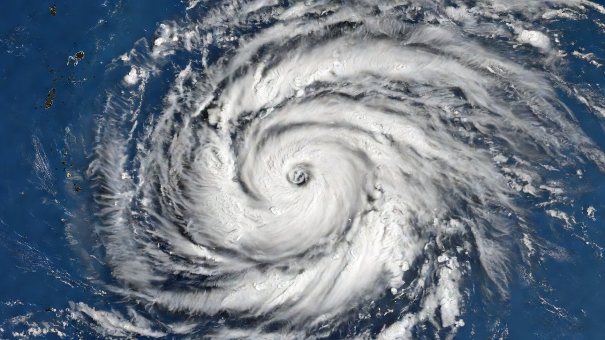
Folks, listen up, because Mother Nature has decided to crank the dial to eleven and we are tracking a monster. We are talking about Typhoon Saudel, a beast of a storm that is churning through the Western Pacific with the kind of fury that makes you want to double-check your emergency kit. This isn't just another weather blip on the radar; this is a high-stakes, multi-nation event that has our friends in Japan, the Philippines, and even our own US territories in the crosshairs. So grab your coffee, folks, because we are diving headfirst into the eye of the storm, and I’m not letting go until you have the full picture.
Super Typhoon Threat: Saudel Bears Down on Okinawa
Atlanta, GA — Article continues...
A Storm With a Name Change
Alright, let’s get the introductions out of the way, because this storm has more aliases than a spy on a secret mission. Internationally, we know it as Typhoon Saudel, a name that has been echoing through forecast offices all week. But the moment it crossed into the Philippine Area of Responsibility, or PAR, at precisely 1:20 p.m. on Monday, August 24th, 2026, it got a new local ID from PAGASA: Obet. And if you’re in Japan, you better believe the JMA is tracking this as Typhoon No. 18. One storm, three names, and a whole lot of anxiety for millions of people.
This isn't just bureaucratic red tape, folks. These naming systems are crucial for public safety, ensuring that local populations know exactly which storm is threatening their specific region. When PAGASA says "Obet," people in the Philippines know to pay attention. When the JMA says "Typhoon No. 18," the folks in Okinawa know it's time to secure the patio furniture. It’s a coordinated dance of meteorological data, and right now, the music is getting intense. The storm formed east of the Philippines on August 19th, making it the 18th named typhoon of this already hyperactive 2026 Western Pacific season, and it has been on a rapid-fire journey ever since.
How Big, How Strong, How Fast
Let’s talk numbers, because the stats on this thing are frankly terrifying. As of the 3:00 p.m. bulletin from PAGASA on Monday, the center of the eye was estimated at a staggering 1,375 kilometers east-northeast of Extreme Northern Luzon. We’re talking coordinates of 24.5°N, 134.6°E, which puts it in a prime position to cause some serious havoc. But the real kicker is the power behind it. PAGASA clocked maximum sustained winds at a jaw-dropping 165 kilometers per hour near the center, with gustiness that can reach up to 205 kilometers per hour. That is not a breeze, folks; that is a freight train made of air.
And if that wasn't enough to make you sit up straight, the Joint Typhoon Warning Center, or JTWC, is reporting even more explosive numbers. Their live data shows current wind speeds of 195 kilometers per hour, with maximum sustained winds peaking at 215 kilometers per hour. The minimum central pressure has bottomed out at 954 hectopascals, which is a classic sign of a deeply powerful and well-organized system. AccuWeather has already classified it as a "violent typhoon," and they’re tracking it approximately 940 kilometers from Kadena Air Base in Okinawa. That’s not a distant threat, folks; that’s a neighbor knocking on the door.
PAGASA weather specialist Aldczar Aurelio earlier reported the storm was spotted about 1,660 kilometers east-northeast of Extreme Northern Luzon, and he dropped a warning that should have everyone on edge: this thing MAY INTENSIFY INTO A SUPER TYPHOON. We are not playing games here. The JMA has rated it "very strong," and as of 9:00 a.m. Monday Japan Standard Time, it was over waters south of Japan, moving west-northwest at a rapid clip of 35 kilometers per hour. This is a fast-moving, rapidly intensifying behemoth, and it is coming for a landing.
Philippines: Monsoon on Top of Typhoon
Now, here’s where the story gets even more complicated, and it’s a classic example of how one weather system can trigger a cascade of effects. While Typhoon Saudel, or Obet, is staying far from the Philippine landmass, it’s not letting the country off the hook. PAGASA expects Obet to remain far from the coast, moving west-northwest and then shifting generally westward, exiting the PAR within about 12 hours—so by Monday night or early Tuesday, August 25th. There is no Tropical Cyclone Wind Signal currently in effect, which is good news for direct wind impacts.
But here is the twist, folks. Saudel, along with Tropical Depression Inari (formerly known as Neneng), is strengthening the southwest monsoon, or what the locals call the "habagat." This is a classic typhoon-monsoon interaction. The typhoon is acting like a giant vacuum, pulling moist, unstable air from the southwest into the Philippines. The result? Heavy monsoon rain is expected to slam northern and central Luzon. So, even though the typhoon itself is a "miss," the rain is a "hit." We are talking about the potential for significant flooding and landslides in areas that are already saturated from a long, wet season. It’s a one-two punch, and the Philippines is bracing for the monsoon wallop.
Japan Braces: Okinawa and Amami in the Crosshairs
Let’s shift our focus to Japan, because this is where the storm’s fury is expected to land with the most impact. The Japan Meteorological Agency has issued a forecast that should have everyone in the region on high alert. Saudel is expected to approach the Okinawa and Amami regions with strong-to-very-strong intensity between August 25th and 27th. We are talking about violent winds, dangerously high waves, and heavy rainfall. This is not a "stay indoors and watch a movie" kind of storm; this is a "batten down the hatches and pray your roof holds" kind of storm.
Naha Airport in Okinawa is already bracing for the storm, which tells you everything you need to know about the expected severity. Flights will be grounded, businesses will shutter, and the entire island chain will be hunkering down. The forecast risk corridor runs from Okinawa toward Taiwan and Fujian, China, with a possible landfall in China late in the week. But for now, all eyes are on the Ryukyu Islands. This is a region that knows typhoons, but the intensity of Saudel is something else. The JMA’s "very strong" rating is not a term they throw around lightly, and the potential for it to reach "super typhoon" status before landfall is a terrifying prospect.
The US Angle: Kadena, the Northern Marianas, and American Troops
Folks, this is where this story hits close to home for us here in the States. We’re not just talking about a faraway storm; we’re talking about a direct threat to American soil and American service members. Kadena Air Base in Okinawa is a linchpin of US military power in the Pacific, and it is sitting right in the path of this monster. With AccuWeather tracking the storm just 940 kilometers away, the base is already on high alert. You can bet that the US military is executing its typhoon preparedness plans, securing aircraft, and moving assets to safer locations. The safety of our troops and their families is paramount, and this storm is a serious test.
But the US connection doesn’t stop there. On August 22nd, Saudel rapidly intensified and passed close to Agrihan in the Northern Mariana Islands, a US territory. This is a stark reminder that the US has sovereign territory in the heart of Typhoon Alley. The Northern Marianas are no strangers to catastrophic storms, and this close pass is a wake-up call. The fact that this storm rapidly intensified near a US territory underscores the unpredictable nature of these systems and the constant vigilance required to protect American citizens in the Pacific. We have boots on the ground and families living in these regions, and they are on the front lines of this climate battle.
A Season That Keeps Delivering
This isn't happening in a vacuum, folks. We are in the thick of a hyperactive typhoon season, and the Western Pacific is a pressure cooker. We currently have three active systems churning at once: Obet (Saudel), Inari (formerly Neneng), and Atsani. It’s a meteorological traffic jam out there, and it’s putting a strain on forecasting resources and emergency management agencies across the region. This is what a busy season looks like, and it’s a reminder that we are in a period of intense tropical activity.
And let’s not forget the context. Japan has already endured extreme rainfall this year. On August 13th, Chiba near Tokyo recorded a record 115 millimeters of rain in a single hour, with nearby Sakura recording 97 millimeters. That is an apocalyptic amount of water, and it shows how vulnerable the region is to hydrologic disasters. Just recently, Typhoon Dolphin blasted past Okinawa toward mainland China, leaving a trail of damage and serving as a grim preview of what Saudel could do. The ground is saturated, the infrastructure is stressed, and the people are weary. This season is relentless, and Saudel is the latest, and perhaps most dangerous, chapter in a story that keeps getting more intense.
What Comes Next
So, what’s the bottom line, folks? The next 48 to 72 hours are critical. The JMA forecast puts Saudel right on top of Okinawa and Amami between August 25th and 27th. We are looking at a direct hit with violent winds and life-threatening storm surge. The storm is expected to move west-northwest, then shift westward, potentially making landfall in China late in the week. But before that, it’s going to wreak havoc on the Japanese islands. The time for preparation is now, not when the winds start howling.
For the Philippines, the immediate concern is the enhanced monsoon rainfall. Even though the typhoon is moving away, the rain will continue to pile up in northern and central Luzon. We are talking about a serious flood threat that could last for days. The combination of a departing typhoon and a strengthened monsoon is a recipe for disaster, and PAGASA is urging residents to remain vigilant. This is a marathon, not a sprint, and the aftermath of the storm could be just as dangerous as the storm itself.
Stay Safe, Stay Informed
Alright, folks, this is the part where I get real with you. We can’t control the weather, but we can control our response to it. If you are in Okinawa, Amami, or anywhere in the forecast path, do not wait. Follow the orders of local authorities. Secure your homes, stock up on water and non-perishable food, charge your devices, and know your evacuation routes. This is not a drill. The power of a "violent typhoon" is something that can level buildings and turn streets into rivers. Take it seriously.
For our viewers in the Philippines, especially in Luzon, heed the warnings about the monsoon rains. If you live in a flood-prone area, move to higher ground. Do not attempt to cross raging rivers or flooded streets. Your life is more valuable than any possession. And for everyone watching, stay informed. This is a rapidly evolving situation, and the forecasts can change. Keep your eyes on PAGASA, the JMA, and the JTWC for the latest updates. We here at Global 1 News are committed to bringing you the facts you need to stay safe. We are in this together, folks. Let’s look out for one another, and let’s ride out this storm with strength and resilience.
By Jessica Ali, Staff Writer
This article was produced with AI-assisted research and editorial support. Sources: PAGASA, Japan Meteorological Agency, JTWC, NHK World, GMA News, The Watchers, AccuWeather, The Guardian, Fox Weather, Japan News/Yomiuri.What's Your Reaction?
 Like
0
Like
0
 Dislike
0
Dislike
0
 Love
0
Love
0
 Funny
0
Funny
0
 Wow
0
Wow
0
 Sad
0
Sad
0
 Angry
0
Angry
0

Editor-in-Chief at Global1.News. Atlanta-based journalist who cuts through the BS and tells it like it is. Lead anchor, host, and the voice you hear when the spin stops and the truth starts.















Comments (0)