
M7.7 Earthquake Strikes Flores, Indonesia: Two Dead, Tsunami Warning Lifted
The ground didn't just shake. It roared. At 5:58 am local time on Saturday, August 15, 2026, a magnitude 7.7 earthquake ripped through the Flores Sea, 68 kilometers north-northwest of Ende on the north coast of Flores Island, East Nusa Tenggara province, Indonesia.
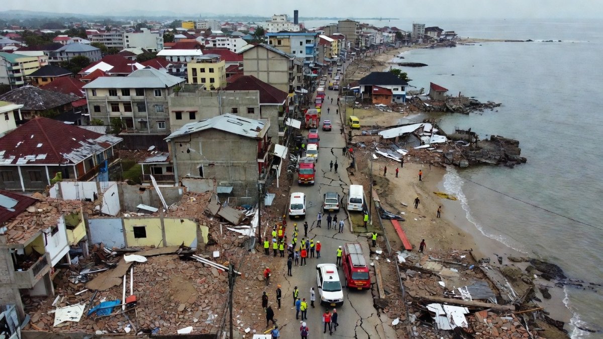
The ground didn't just shake. It roared. At 5:58 am local time on Saturday, August 15, 2026, a magnitude 7.7 earthquake ripped through the Flores Sea, 68 kilometers north-northwest of Ende on the north coast of Flores Island, East Nusa Tenggara province, Indonesia. The US Geological Survey clocked the depth at a terrifyingly shallow 10 kilometers — the kind of depth that turns a big quake into a catastrophic one. Within minutes, the sea pulled back from the shore in Nagekeo regency, the closest populated area to the epicenter. That's the oldest warning sign in the book, and it means one thing: a tsunami may be coming.
M7.7 Earthquake Strikes Flores, Indonesia: Two Dead, Tsunami Warning Issued and Lifted, Aftershocks Rattle the Region
Ende, Indonesia — The quake hit at 5:58 am local time Saturday (21:58 GMT Friday), according to the USGS. The epicenter sat 68 km north-northwest of Ende, a city of 87,269 people, and 70 km NNW of Maumere, home to 87,720. The rupture occurred along a reverse fault at shallow depth, driven by the relentless convergence of the Australia and Sunda plates — the same tectonic machinery that has shaped this region's violent history. The USGS issued a Yellow alert for shaking-related fatalities and losses, noting that some casualties and damage are possible, with impact expected to be relatively localized. But as the morning unfolded, the picture got more complicated.
Two Dead at Maumere Port, Casualty Count Could Rise
The first confirmed deaths came from the port town of Maumere. A man and a woman were killed there, according to the BNPB, Indonesia's national disaster agency. One other person was reported injured. BNPB spokesman Berton Suar Pelita Panjaitan was careful with his words: "At this point there are two reported fatalities." He added, "Once the data are confirmed, we will officially announce the final number of casualties and the extent of damage to buildings caused by the earthquake." The phrasing signals that the count could rise as damage assessments come in.
The USGS estimates more than half a million people on Flores experienced very strong shaking. The agency's watchers put the numbers at 56,000 people in severe shaking, 420,000 in very strong shaking, 1,171,000 in strong shaking, and 2,712,000 in moderate shaking. That's a lot of people who felt the earth move under their feet — and a lot of buildings that may not have survived the test.
Tsunami Warning: Issued, Then Lifted
Indonesia's Meteorology, Climatology and Geophysics Agency, known as BMKG, didn't wait around. It issued a tsunami warning for parts of West Nusa Tenggara, East Nusa Tenggara, South Sulawesi, and Southeast Sulawesi — 22 areas under alert. Tsunami modeling suggested potential waves of 0.5 to 3 meters. That's not a gentle swell; that's a wall of water that can sweep people off their feet and knock buildings down.
BMKG earthquake and tsunami director Wijayanto, who goes by one name, told reporters: "We have ended (the tsunami warning) but we will keep monitoring the sea level." The warning was lifted after monitoring showed no significant sea-level threat. Authorities detected tsunami waves between 19 and 30 centimeters — enough to notice, not enough to devastate. But the warning served its purpose: it got people moving.
Evacuations and the Sea That Pulled Back
In Nagekeo regency, closest to the epicenter, residents raced for higher ground as the sea retreated — a possible sign of an approaching tsunami, according to AFP journalists on the scene. Hundreds evacuated amid the rubble of damaged buildings, Indonesian TV reported. For anyone who knows the history of this region, a receding sea is the moment you run.
BNPB official Abdul Muhari was blunt: "We strongly urge our communities along the northern coast of Flores and in the southern parts, on the southern islands and across the southern region, to carry out self-evacuation immediately." He urged residents to move more than 2 kilometers inland or to hilly areas more than 10 meters (33 feet) high. Australia's tsunami warning center confirmed there was no threat to the Australian mainland, islands, or territories — a small relief for the region's southern neighbor.
Damage Across Flores: Collapsed Port, Cracked Walls, Evacuated Patients
The damage is spread across the island. In Maumere, the waiting room at the port terminal collapsed. In Ruteng, in the Manggarai regency, houses were damaged. In Talibura Village, Sikka, buildings took hits. Patients were evacuated from the Watubaing community health center. The full extent of the damage is still emerging — local authorities haven't been able to reach several affected areas, which Al Jazeera's Jessica Washington in Jakarta described as "locked" for first responders. That's the nightmare scenario: the earthquake hits, and then it blocks the roads that would let you help the people it hurt.
Witnesses described the chaos. Lukas Lotar, 31, a hospital customer service official, told AFP: "Suddenly it started to shake and I panicked. Patients also fled the hospital, the jolt was big. I saw some walls were cracked." Yohanes Babo, 56, was at a market in Nagekeo: "The shaking was strong. Thankfully, we were already outside the house. People were panicking, running here and there. We're evacuating for the time being … and trying to get to the hills. My family is safe. No one was harmed." Yohanna Embu, a Sikka resident, said: "Many buildings here were damaged … I saw that the waiting room at the port terminal in Maumere had collapsed."
Aftershocks: The Ground Won't Stay Still
Within about half an hour of the main quake, three significant aftershocks rattled the region: a magnitude 5.9 at 5:13 am, 36 km northeast of Labuan Bajo; a 5.6 at 5:18 am, 61 km NNW of Ende; and a 6.1 at 5:28 am, 58 km north of Ende, according to USGS. RNZ and USGS reported a series of seven aftershocks ranging from 5.0 to 6.1. FOX Weather counted at least 10 to 11 aftershocks, including a 5.5 at 5:37 am. Local weather agencies warned that aftershocks could persist for several days. That's not just an inconvenience — it's a threat. Every aftershock can bring down a building that was already weakened, can trigger a landslide on a slope that's already unstable, can push a community that's already on edge into panic.
The Ring of Fire: Indonesia's Seismic Inheritance
This is not a surprise. Indonesia is home to more than 270 million people spread across roughly 17,000 islands, and it sits on the Pacific "Ring of Fire," one of the most seismically active regions on Earth. The USGS notes that since 1950, there have been 37 other magnitude 6+ earthquakes, including five magnitude 7+ quakes, within 250 kilometers of this epicenter. Recent earthquakes in this area have caused secondary hazards such as tsunamis and landslides. This is a country that has learned, again and again, that the ground beneath its feet is a living thing — and it doesn't always sleep.
The history is written in tragedy. In December 1992, a magnitude 7.8 earthquake struck 63 km east-southeast of this epicenter and triggered a tsunami that killed more than 2,500 people on Flores. In December 2004, the magnitude 9.1 Sumatra earthquake and tsunami killed more than 220,000 people across the region, including approximately 170,000 in Indonesia. In 2018, the Lombok earthquakes killed more than 550 people, and the Palu earthquake and tsunami left more than 4,300 dead or missing. This is a region that has been shaped by catastrophe — and it has also been shaped by resilience.
Landslide Risk and the USGS Ground-Failure Model
The USGS ground-failure modeling shows significant potential for earthquake-triggered landslides. That's a quiet threat that doesn't make the headlines as fast as a tsunami, but it can be just as deadly. A landslide can bury a village, block a river, or cut off a road that's the only lifeline for a community. In a region with steep terrain and heavy rainfall, the risk is real. The USGS also noted that this is among the strongest earthquakes recorded worldwide so far in 2026 — a year that has already seen the magnitude 7.4 Choco, Colombia earthquake on August 10, which left more than 265 dead, according to prior coverage.
What This Means for You
Here's the thing about earthquakes: they don't care about your plans. They don't care about your politics, your borders, or your stock portfolio. They just happen. And when they happen in a place like Indonesia, the ripple effects are felt far beyond the epicenter. The global supply chain, the tourism industry in Bali and Labuan Bajo, the regional economy — all of it takes a hit. But the real cost is human. Two people are dead. More may be found. Hundreds are displaced. Thousands are sleeping outside tonight because they're afraid of what their own homes might do to them.
For readers in the United States, this is a reminder that the Pacific Ring of Fire doesn't stop at Indonesia. It runs all the way up through Japan, the Philippines, and across the Pacific to the west coast of North America. The same tectonic forces that shook Flores are at work off the coast of California, Oregon, and Washington. The USGS Yellow alert is a reminder that even a "moderate" event in a seismically active region can have deadly consequences. And the fact that the tsunami warning was lifted doesn't mean the next one will be.
For the people of Flores, the immediate priority is survival. The aftershocks will continue. The damage assessment will take days. The recovery will take years. But the people of this region have been through this before — in 1992, in 2004, in 2018 — and they have rebuilt every time. They will rebuild again. The question is whether the rest of the world will pay attention long enough to help.
By Jessica Ali, Staff Writer
This article was produced with AI-assisted research and editorial support. Sources: US Geological Survey, BMKG, BNPB, The Guardian, Al Jazeera, Reuters, AFP, Channel News Asia.
What's Your Reaction?
 Like
0
Like
0
 Dislike
0
Dislike
0
 Love
0
Love
0
 Funny
0
Funny
0
 Wow
0
Wow
0
 Sad
0
Sad
0
 Angry
0
Angry
0

Editor-in-Chief at Global1.News. Atlanta-based journalist who cuts through the BS and tells it like it is. Lead anchor, host, and the voice you hear when the spin stops and the truth starts.















Comments (0)