
Karon Named Model Area for Landslide Risk Assessment After Deadly 2024 Phuket Disaster
Thailand's Department of Mineral Resources has named Karon in Phuket as a model area for landslide risk assessment, two years after a 2024 debris flow killed 13 people. The project includes risk mapping, early-warning systems and community networks.
In a landmark move for Thailand's disaster preparedness, the Department of Mineral Resources (DMR) has designated Tambon Karon in Muang district of Phuket as a model area for landslide risk assessment and mitigation, two years after a devastating debris flow killed 13 people on the island's famous western coast. The announcement, made this week in Bangkok, marks a significant shift toward proactive geological hazard management in a province that generates more than 545 billion baht in annual tourism revenue. The pilot project, launched in fiscal 2026, aims to create a comprehensive blueprint for protecting residents, tourists, and critical infrastructure across Thailand's most valuable island destination.
The selection of Karon comes as Thailand's rainy season intensifies, with the southwest monsoon bringing sustained downpours that have historically triggered deadly flash floods and landslides across the country's mountainous southern provinces. For Thai communities from Chiang Mai to Phuket, the initiative represents a critical step in translating geological knowledge into actionable community-level protection, addressing a gap that proved fatal in August 2024 when a channelised debris flow tore through residential areas at the foot of Nakkerd Hill.
Phuket's Karon Becomes Landslide Risk Model After 2024 Tragedy
Bangkok, Thailand – Monday — The Department of Mineral Resources has officially launched a comprehensive landslide risk assessment and prevention project in Karon, Phuket, using the area as a pilot site to develop systems that can be replicated across Thailand and potentially the wider ASEAN region. Supaporn Worakanok, director of the DMR's Environmental Geology Division, confirmed that landslides in Thailand have become more frequent and severe in recent years, prompting the department to apply geological knowledge directly on the ground to help local authorities reduce risks and strengthen communities' ability to respond to disasters.

A Deadly Lesson: The August 2024 Nakkerd Hill Disaster
The urgency of the Karon project is rooted in the catastrophic events of August 23, 2024, when a channelised debris flow at Nakkerd Hill — also known locally as Nak Koet Hill — struck houses at the foot of the slope following intense rainfall. The disaster killed 13 people, injured 19 others, and affected 209 households across nine villages, including Soi Patak 2, Soi Patak 4, and the wider Karon sub-district. Among the victims were a Russian couple and several Myanmar citizens, underscoring the international dimension of Phuket's vulnerability.
Geological investigations revealed that the landslide occurred on a cliff with an approximately 80-degree slope, where trees covered only the topsoil layer. The debris flow consisted of large rocks, gravel, sand, and trees — a mass roughly 10 by 10 meters that surged down the mountainside with the water. The underlying geology is Kata granite, dating back 91 to 105 million years, which has weathered over millennia into a fragile surface layer covered by sediment, making the terrain particularly susceptible to failure during prolonged heavy rain or intense rainfall over short periods.
The Big Buddha Question: Development vs. Sacred Ground
In the aftermath of the 2024 disaster, investigators examined the potential role of the Big Buddha Temple — Phra Phuttha Mingmongkol Eknakiri — whose construction on Nakkerd Hill began in 2005. Colonel Dusit Kaesonkaew of the 4th Army Area investigation team stated that the project failed to implement proper water division techniques, noting that "the construction and land modification blocked natural waterways. When heavy rain occurs, water seeks new paths down the mountain. The landslide area appears to be one such new water path."
The Big Buddha statue itself is a monumental structure: a base width of 25.45 meters, a height of 45 meters, built of reinforced concrete and decorated with white "Suriyakanta" jade marble from Myanmar, with the marble weighing approximately 135 tons and covering 2,500 square meters. Located in a Buddhist park at the top of Nakkerd Hill, the site is both a major pilgrimage destination and a symbol of the tension between development and environmental stewardship. Major General Anusorn O-urai, Deputy Commander of the 4th Army Area, said at the time: "This clearly indicates that the encroachment and destruction of natural resources is causing significant losses in terms of life, property, and Thailand's tourism."
Satellite imagery showed soil and rock base movement in the area since February 2024, months before the fatal slide. Dave Petley's Landslide Blog, published through the American Geophysical Union in October 2024, called the Karon disaster "a textbook example of the ways in which poor slope management, and the location of people in high risk zones, can combine to cause a tragedy."
Why Karon: Geology, Terrain, and Economic Stakes
Suwapak Imsamut, deputy director-general of the DMR, explained that Karon was selected as the model area because of its steep terrain and its location connecting upland catchment areas with communities and major tourist attractions. The area's weathered granite geology, covered by layers of sediment, makes it particularly vulnerable to landslides following prolonged heavy rain or intense rainfall over short periods — conditions that are becoming more common as regional weather patterns shift.
The economic imperative is clear. Phuket generates more than 545 billion baht in tourism-related revenue annually, making safety and disaster preparedness crucial to the government's plan to develop the island as a global tourism hub. Karon, alongside Kata and Patong, is one of Phuket's most famous beach areas, drawing international visitors year-round. A single disaster event, like the 2024 landslide, not only claims lives but also erodes confidence in Thailand's premier island destination, with ripple effects across the hospitality, aviation, and retail sectors that depend on continuous tourist arrivals.
Building Resilience: Risk Maps, Early Warning, and Community Networks
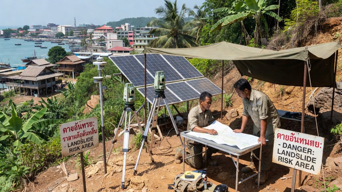
The DMR's comprehensive approach for Karon includes several interlocking measures designed to protect both residents and visitors. Landslide and flash-flood risk maps are being developed at high resolution, with data intended to support zoning decisions and identify areas at particularly high risk, especially in economically important locations. Monitoring and early-warning systems are being installed, including equipment to detect ground movement in high-risk mountainous areas — a critical capability given that satellite imagery showed movement months before the 2024 disaster.
The department is also designating geological safety zones across Phuket to serve as evacuation areas for residents and tourists during emergencies. Community networks for initial disaster response are being developed, building on Thailand's existing village headman system and tambon administration organizations (OrBorTor) that form the backbone of local governance. A detailed information database and guidelines for preventing soil erosion and landslides are being created specifically for Karon, with the goal of providing local authorities with actionable data rather than abstract geological assessments.
From Paper to Practice: Evacuation Drills and Ground Detection
The project has already moved beyond planning. In April 2026, authorities ordered full-scale evacuation drills in Karon as part of urgent measures to strengthen landslide preparedness ahead of the rainy season. The drills followed a high-level meeting at the Phuket Provincial Disaster Prevention and Mitigation Office, chaired by Vice Governor Teeraphong Chuaychoo, which brought together provincial officials, military representatives, and local administrators to coordinate response protocols.
Advanced surveying technologies, including LiDAR and drone mapping, have already detected ground movement in multiple areas around Karon, including newly identified high-risk zones where no previous incidents have occurred but conditions indicate landslides are likely under sustained rainfall. Officials have stressed the importance of using academic research and data-driven analysis to guide planning, rather than relying solely on historical incident records. In September 2024, Phuket Governor Sophon Suwannarat received 30 rain gauges from the DMR deputy director-general, along with maps of risky landslide areas for 15 sub-districts, to be distributed to village headmen in high-risk areas — a practical step that puts monitoring tools directly into community hands.
Regional Implications: A Model for Southeast Asia
Thailand's approach in Karon carries significance well beyond Phuket's beaches. Across Southeast Asia, from Indonesia's volcanic slopes to Vietnam's central highlands and the Philippines' typhoon-prone provinces, communities face intensifying landslide and flash-flood risk under changing rainfall patterns. Tourism-dependent economies throughout the region share Phuket's vulnerability: a single disaster can devastate local livelihoods and national reputations in an industry built on perceptions of safety and natural beauty.
The DMR's model — combining high-resolution geological mapping, ground-movement detection, community early-warning networks, and designated evacuation zones — offers a template that could be adapted for other ASEAN destinations facing similar geological hazards. For Thailand, the Karon project represents a shift from reactive disaster response to proactive risk management, acknowledging that the country's economic future depends on protecting the natural and built environments that sustain its tourism industry.
As the rainy season progresses and the southwest monsoon continues to test Phuket's hillsides, the lessons from Karon will be watched closely by disaster management agencies across the region. The 2024 tragedy claimed 13 lives and injured 19 people; the question now is whether the systems being built in its wake can prevent the next disaster from occurring — and whether Thailand's approach can serve as a regional standard for living safely with the region's volatile geology.
By Ann Srisawat, Staff Writer
This article was produced with AI-assisted research and editorial support. Reporting is based on sources cited in the article.
What's Your Reaction?
 Like
0
Like
0
 Dislike
0
Dislike
0
 Love
0
Love
0
 Funny
0
Funny
0
 Wow
0
Wow
0
 Sad
0
Sad
0
 Angry
0
Angry
0

Southeast Asia Correspondent at Global1.News. Based in Bangkok, covering Thai and Southeast Asian politics, economy, technology, and culture. Deep regional perspective on one of the world's most dynamic regions.















Comments (0)