
Guatemala's Fuego Volcano Eruption: Evacuations and Alerts
Guatemala's Fuego volcano erupted powerfully on Monday, sending gas, ash, and pyroclastic flows down its slopes. The event highlights the persistent volcanic hazards along Central America's Pacific coast. Guatemala City, Guatemala - Fuego volcano in Guatemala began a powerful eruptive phase on Monday, August 3, 2026, around 08:30 local time. Guatemala's National Institute of Seismology, Volcanology, Meteorology and Hydrology, known as INSIVUMEH, recorded the onset.
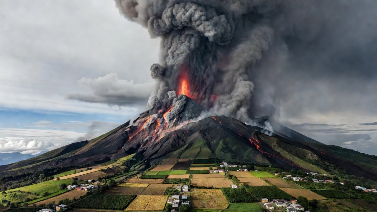
Guatemala's Fuego volcano erupted powerfully on Monday, sending gas, ash, and pyroclastic flows down its slopes. The event highlights the persistent volcanic hazards along Central America's Pacific coast.
Guatemala City, Guatemala - Fuego volcano in Guatemala began a powerful eruptive phase on Monday, August 3, 2026, around 08:30 local time. Guatemala's National Institute of Seismology, Volcanology, Meteorology and Hydrology, known as INSIVUMEH, recorded the onset. The eruption produced gas, ash, lava, and pyroclastic flows that moved down the mountain, with continued emissions of mud and ash into Tuesday, August 4.
A Fiery Wake-Up Call From the Ring of Fire
Guatemala lies along the Pacific Ring of Fire, where tectonic plates converge and sustain frequent seismic and volcanic activity. Fuego is one of the most active volcanoes in Central America and the Western Hemisphere. Its location ensures that such events occur regularly, and the current phase follows that established pattern.
The Pacific Ring of Fire is a large belt surrounding the Pacific Ocean where ongoing plate motion drives hundreds of active volcanoes and repeated earthquakes. Guatemala's placement within this zone means volcanic unrest is a recurring feature, and communities near peaks such as Fuego maintain routine preparedness measures. Residents monitor signs including rumbling sounds and variations in steam output, as prior cycles have shown that early recognition supports safety.
Central America's volcanic chain features other active peaks driven by the same tectonic setting. Pacaya near Guatemala City has generated repeated lava flows and ash emissions in recent years, while Santiaguito in the western highlands maintains long-term lava dome growth. These volcanoes illustrate that Fuego's activity belongs to a wider regional sequence, supporting coordinated monitoring across borders.
The subduction of the Cocos Plate beneath the Caribbean Plate creates the magma that fuels Fuego and its neighbors. This process has produced a long record of eruptions that communities have learned to anticipate through generations of observation. INSIVUMEH maintains instruments that capture subtle shifts in ground deformation and gas output, allowing scientists to place each new phase within the volcano's documented history.
Regional cooperation has strengthened in recent years as neighboring countries share data on plume movement and seismic patterns. Such exchanges help refine forecasts for ash dispersal that can cross borders within hours. The current episode reinforces the value of these networks when activity intensifies without extended warning.
What's Happening Right Now
Pyroclastic density currents traveled 5 to 7 kilometers down the Seca ravine and the Ceniza ravine. Lava fountains accompanied an ash column that reached 5,000 to 6,000 meters above sea level. The Guardian reported lava and ash rising nearly four miles into the sky.
Mudflows, or lahars, extended up to 7 kilometers. Ashfall affected areas impacting roughly 29,000 people, including reports from San Pedro Yepocapa. Authorities declared an orange alert, the second-highest level, and raised it to red for the three villages nearest the volcano.
Access to Acatenango and Fuego hiking areas was closed until further notice. Alotenango lies about 65 kilometers southwest of Guatemala City. CONRED, Guatemala's national disaster-response agency, directs the on-site response.
Additional monitoring stations along the ravines recorded sustained seismic signals that track material movement after the initial blast. These readings allow responders to adjust evacuation zones in real time.
Teams on the ground continue to sample ash deposits to determine grain size and composition, information that helps predict how far future flows might travel. Visual observations from safe vantage points supplement instrument data when weather permits. Coordination between field crews and the national emergency operations center remains constant while the alert level stays elevated.
Economic Impacts on Tourism and Agriculture
The slopes around Fuego support extensive coffee plantations that form a key part of Guatemala's agricultural exports. Ashfall can reduce photosynthesis temporarily, and heavier deposits may require removal to limit effects on soil. Farmers in nearby communities often experience weeks of interrupted harvest schedules when alerts restrict field access during peak periods.
Tourism operators near Antigua and Alotenango recorded immediate cancellations from visitors planning hikes or tours. Hotels and guiding services face revenue losses that affect local economies still recovering from earlier events. Businesses note that clear communication on safety measures supports continued visitor confidence once activity declines.
Coffee cooperatives near the volcano maintain contingency plans that include temporary worker relocation and storage of harvested beans outside ash zones. These measures protect both incomes and the flavor profiles that distinguish Guatemalan coffee. Agricultural extensions continue advising growers on post-eruption soil testing to restore output.
Antigua's status as a UNESCO World Heritage site draws international visitors whose spending supports restaurants, artisans, and transport services. When trails to the volcano close, tour operators shift focus to cultural sites within the city, yet the overall reduction in overnight stays still registers across the hospitality sector. Recovery typically accelerates once INSIVUMEH confirms that ash emissions have returned to background levels.
Longer-term planning by agricultural associations includes investment in ash-resistant storage facilities and diversified crop varieties. These steps aim to reduce the duration of income disruption when eruptions coincide with critical growing or harvest windows. Government agricultural programs continue to monitor market prices to detect any ripple effects on export contracts.
What Scientists Are Watching for Next
INSIVUMEH teams continue monitoring for lahars that could form if rain remobilizes fresh ash deposits in coming days or weeks. Additional pyroclastic flows remain possible if the eruptive column collapses, requiring ongoing seismic and gas surveillance. Aviation authorities have issued advisories for Guatemala City airport concerning possible ash clouds that could affect flight paths.
Regional aviation centers share plume models with neighboring countries to limit airspace disruptions. Scientists also track gas composition changes that may indicate deeper magma movement, feeding updated hazard maps for CONRED briefings.
During the upcoming rainy season, engineers inspect drainage channels near populated areas to reduce the risk of lahars reaching roads and homes. Historical patterns show that even modest rainfall can mobilize loose material for months after an eruption ends. Updated hazard maps incorporate these seasonal factors to guide future land-use decisions.
Why Fuego Requires Constant Monitoring
Fuego's record of abrupt changes keeps it under continuous observation. The current flows remained largely within ravines, yet the scale of activity explains why monitoring persists. When ash columns reach those heights and pyroclastic currents extend several kilometers, the energy involved can affect unprepared areas rapidly. This is why alerts were issued early and evacuations began promptly.
The volcano's activity underscores that preparation is essential for communities near active zones. Data from INSIVUMEH supports a clear operational picture and focused response.
Instrument networks installed after previous episodes now provide higher-resolution data on tremor amplitude and tilt changes. These improvements allow earlier detection of shifts that previously went unnoticed until flows were already moving. Continuous training for local observers complements the technology by ensuring rapid reporting of visible changes.
The 2018 Eruption That Changed Response Protocols
In June 2018, a more destructive Fuego eruption sent pyroclastic flows across the Las Lajas ravine, killing nearly 200 people and leaving hundreds missing. That event prompted closer examination of how quickly flows can leave channels and reach populated areas. Current evacuations reflect lessons from that episode.
The 2018 disaster demonstrated the consequences when flows overspill established paths. Today's response treats every possible route seriously because the same volcano operates under comparable conditions. Evacuation calls were issued early and maintained.
Post-2018 reviews led to expanded buffer zones and clearer triggers for moving residents from higher-risk ravines. CONRED now maintains updated contact lists for each community and conducts regular drills that simulate overnight shelter stays. These preparations have shortened the time between alert issuance and completed evacuations in subsequent events.
The Human Toll: Evacuations and Shelters
Authorities ordered the evacuation of up to 30,000 people. At least two villages on the slopes were cleared. As of August 5, about 1,700 evacuees remained in shelters, many at a site in San Juan Alotenango. No confirmed deaths have been reported in this eruption.
CONRED manages the shelter operation and supply distribution. Ashfall continues to disrupt routines for thousands who did not evacuate. The priority remains keeping residents safe while the volcano remains active.
Evacuees describe crowded shelter conditions where families share space while awaiting updates on homes and livestock. Children attend volunteer-organized classes, and health workers distribute masks to reduce breathing issues from ash. CONRED arranges daily deliveries of food, water, and hygiene supplies while maintaining registries to reunite families.
Experience from 2018 has informed current shelter procedures, including separate livestock areas and improved communication systems that deliver voice messages in local languages. These changes emphasize both safety and resident needs during extended absences from home.
Many families bring essential documents and small livestock when they leave, yet space constraints require careful organization of shared facilities. Health teams monitor respiratory symptoms and provide hydration stations to counter the effects of fine ash. CONRED continues to rotate staff to prevent fatigue while the alert remains in place.
What Travelers and Families Need to Know
Park access remains closed, so plans to hike Acatenango or Fuego must be postponed. Airborne ash can irritate lungs and eyes, particularly for children and older adults. Families in affected zones should follow CONRED updates and maintain emergency supplies.
The orange alert applies to broader areas while red warnings target the closest villages. Travelers should consult official sources before approaching the region, as conditions can change.
Airports in the region continue normal operations but advise pilots to review ash-avoidance procedures. Residents are encouraged to seal windows and doors when ashfall is reported and to avoid outdoor exertion until deposits are cleared. CONRED maintains a public hotline that provides recorded updates in Spanish and several Mayan languages.
How People Can Help
Communities in Guatemala and elsewhere can assist relief by donating to recognized organizations working with CONRED on shelter supplies and medical support. Contributions of non-perishable food, water containers, or protective masks address immediate needs without straining local systems. Those outside the area can share official alerts from INSIVUMEH and CONRED on social media to ensure accurate information reaches families still deciding on evacuation.
Checking verified government channels remains a key step. Regular updates reduce the spread of rumors that could lead to unsafe returns to restricted zones. Sharing clear facts strengthens community resilience during recovery.
Local businesses have begun collecting donations of blankets and infant supplies at collection points coordinated with municipal authorities. International partners continue to route funds through established NGOs that coordinate directly with CONRED logistics teams. Volunteers with medical or translation skills are invited to register through official channels to support shelter operations.
The Bottom Line
This eruption demonstrates that the ground remains dynamic and subject to sudden change. Guatemala's monitoring and response teams acted quickly, and the absence of reported deaths to date reflects that readiness. Work continues as long as ash emissions and flows persist.
Follow INSIVUMEH and CONRED for current alerts. Check on neighbors who may need assistance reaching shelters. Support local relief with donations or supplies where possible. Timely information and coordinated action help communities remain secure when volcanic activity occurs.
By Jessica Ali, Staff Writer
This article was produced with AI-assisted research and editorial support. Reporting is based on sources cited in the article.
What's Your Reaction?
 Like
0
Like
0
 Dislike
0
Dislike
0
 Love
0
Love
0
 Funny
0
Funny
0
 Wow
0
Wow
0
 Sad
0
Sad
0
 Angry
0
Angry
0

Editor-in-Chief at Global1.News. Atlanta-based journalist who cuts through the BS and tells it like it is. Lead anchor, host, and the voice you hear when the spin stops and the truth starts.











Comments (0)