
US Map Blunder at AIDS 2026 Insults African Nations
There is a particular sting — familiar to every African who has ever watched the world draw our continent — in seeing your own country misplaced on a map.
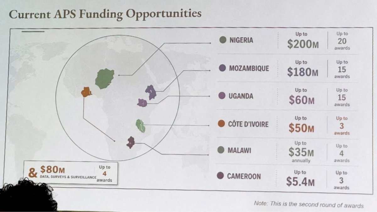
There is a particular sting — familiar to every African who has ever watched the world draw our continent — in seeing your own country misplaced on a map. In Rio de Janeiro, Brazil, this week, attendees at the 26th International AIDS Conference watched a senior United States official's presentation do exactly that: placing Nigeria in the Sahara, throwing Ivory Coast to the other side of Africa, and rendering every highlighted nation unrecognisable. For a continent that has carried the heaviest burden of the HIV epidemic, it felt less like a technical glitch than confirmation of an old, weary suspicion about how Africa is still seen.
US Map Blunder at AIDS 2026 Insults African Nations
Dakar, Senegal — Article continues...
The Map That Misplaced a Continent
The slide appeared during a State Department presentation about Washington's funding for programmes tackling HIV, delivered by a senior official overseeing PEPFAR — the President's Emergency Plan for AIDS Relief, Washington's flagship global HIV programme. Six African countries were highlighted: Nigeria, Mozambique, Ivory Coast (Côte d'Ivoire), Uganda, Malawi and Cameroon. Four of them — Nigeria, Mozambique, Ivory Coast and Malawi — were incorrectly positioned. Nigeria, a coastal West African nation, appeared landlocked, marooned in the Sahara. Ivory Coast, which sits on the Atlantic side of the continent, was shown on the opposite side. Uganda was roughly in the right place but misshapen. Cameroon was mentioned in the map's key, but its name was not linked to any country on the map. The shapes of the countries were unrecognisable.

This was not an obscure internal document. It was the State Department performing before the world, at the largest international gathering on HIV, at a conference about a disease whose epicentre has been sub-Saharan Africa. In the room, watching, were high-level African officials — partners who have led the epidemic response in their countries with courage and clarity. They did not need a map to know where they were. They needed the people drawing the map to know too.
An Audience That Deserved Better
The presentation was meant to show Washington's commitment to funding HIV treatment and prevention across the continent. Instead, it showed something else: a superpower's instruments of statecraft, hurried and unattended, producing an image that should never have reached a formal stage. The mistake came to light after Emily Bass, an HIV/AIDS expert, shared a photograph of the slide on her Substack newsletter. Within hours, the image was spreading across the internet, prompting widespread criticism from scientists, activists and diplomats — and from Africans with long memories of other times the continent has been drawn carelessly.
Across the continent, the reaction mixed anger with a grim, knowing humour. Some pointed out that the officials who could not find Nigeria on a map were still deciding how many dollars would flow to clinics there. Others noted, with the patience of people who have been underestimated for centuries, that Africa has always known itself, even when others do not. But the humour did not hide the hurt. Geography is the language of sovereignty. When a country cannot be located on an official government chart, it is a sign that someone, somewhere, is not paying attention to the people who live there.
The Empty Chair at the Drawing Board
Then came the details that turned an awkward episode into an alarming one. According to an analysis by the Reuters news agency, the image contained an artificial-intelligence watermark, indicating it had been created using AI tools. OpenAI said it was investigating the report. The State Department called the incident "an unfortunate error," explaining that a team member "hurriedly altered" the slide deck shortly before the event. A spokesperson said the department took "full responsibility for the confusion and misrepresentation it caused for attendees, including our African partners."
An apology, however sincere, cannot restore the institutional memory that has been lost. Senator Jeanne Shaheen, the ranking Democrat on the Senate Foreign Relations Committee, was blunt: "What an embarrassment. This is what happens when [the State Department] fires career experts and tries to have AI conduct diplomacy." Cameron Hudson, a former State Department official, called the mistake "stupid and embarrassing" — the result of "too junior staff performing work under-supervised." Both critiques point to the same wound: the people who once knew Africa are no longer in the room, and the tools that replaced them cannot see.
This matters beyond maps. For decades, the fight against HIV in Africa has been won by people: epidemiologists who tracked the virus through townships and villages; nurses who walked kilometres to reach patients on antiretroviral therapy; community counsellors who fought stigma in the years when silence was a death sentence. To imagine that such a struggle can be entrusted to an algorithm — or that a map of our continent can be produced without a single knowledgeable human looking at it — is not just embarrassing. It is dangerous.
Cuts, Closures and a Continent Reckoning
The map blunder also did not happen in a vacuum. The International AIDS Conference opened against the backdrop of deep United States cuts to foreign aid introduced after Donald Trump returned to the White House last year. PEPFAR — a programme created in 2003 and credited with saving millions of African lives — has seen its core life-saving treatment programmes largely resume. But Washington is scaling back spending in other areas, including prevention and disease surveillance, and plans to phase out the programme in South Africa, the country with the world's largest HIV epidemic.
The BBC has reported that some African nations are now turning down American aid money — a sign of both pride and pragmatism. South Africa's fight against AIDS is getting harder as US cash dries up. In this climate, a map that cannot place African countries correctly is not merely a diplomatic faux pas. It is a metaphor for an unfolding reality: a continent forced to chart its own course, with or without reliable maps from Washington.
Here in Senegal, we know something about being looked over. We sit at the westernmost point of Africa, the Cap-Vert peninsula pushing into the Atlantic like a hand extended toward the Americas. Our country is unmistakable on any accurate map. Yet the institutions that can map every highway in Europe can still reach for a tool and pull out a distorted Africa. The question is no longer whether they will learn to see us. The question is whether we will keep waiting for them to do so.
What the Map Cannot Do
And yet. I keep returning to a thought that has nothing to do with pixels or watermarks. The map cannot actually relocate Nigeria, any more than it can wash Ivory Coast into the Indian Ocean. The real Africa — the one that exists far beyond any slide deck — is written in red Sahelian soil, in the Atlantic waves breaking against Cap-Vert, in the deep waters of Lake Malawi, in the forests of Cameroon, in the crowded, brilliant streets of Lagos and Abidjan. No artificial intelligence, no hurried staffer, no under-supervised intern can alter a single contour of it.
This is the deeper truth of the episode. Africa is not a small thing, not a footnote, not a jumble of unrecognisable shapes. It is fifty-four nations and more than a billion people — a continent whose demographic future will shape the world. That the United States can still produce an official map like this in 2026 tells us something painful about how the most powerful institutions on earth see us. But what it tells us about ourselves matters more: we know exactly where we are. We have weathered pandemics, economic storms and the indifference of distant capitals. We will survive bad cartography.
An Apology Is Not a Strategy
The State Department said discussions at the conference had been "substantive and constructive" and reaffirmed its commitment to combating HIV/AIDS in Africa. Those words, if matched by deeds, will restore some of what was shaken. But trust is not rebuilt with a statement. It is rebuilt when career experts return to the desks; when junior staff are properly supervised; when every AI-generated image is reviewed by a human hand; and when African officials sit at the table as equal partners — not as guests obliged to endure the embarrassment of their homelands being flung across a broken map.
For us, the lesson is both bitter and clarifying. As some African nations turn down American aid money and South Africa braces for the phasing out of PEPFAR, the continent is being forced to speak its own name with greater confidence. We have the scientists, the activists, the community health workers — people who for decades have done the work of medicine and memory and love. The map was wrong. The continent it attempted to erase is not. From Dakar to Lagos to Maputo, and everywhere between, Africa remains unmissable.
By Amara Diop, Staff Writer
This article was produced with AI-assisted research and editorial support. Reporting is based on sources cited in the article.
What's Your Reaction?
 Like
0
Like
0
 Dislike
0
Dislike
0
 Love
0
Love
0
 Funny
0
Funny
0
 Wow
0
Wow
0
 Sad
0
Sad
0
 Angry
0
Angry
0
West Africa/Sahel Correspondent at Global1.News. Dakar-based journalist covering politics, security, climate, and development across Francophone and Anglophone West Africa. Tells the stories of a region undergoing profound transformation.











Comments (0)