
Neneng Forms, Monsoon Surge Threatens Luzon
Tropical Depression Neneng formed east of Extreme Northern Luzon on Tuesday, the Philippines' 14th cyclone of 2026, and is set to supercharge monsoon rains across Luzon and the Visayas, raising flood risks through Wednesday.
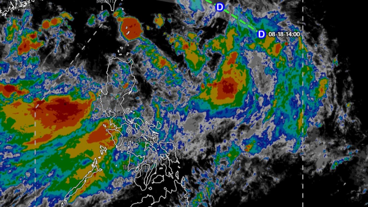
Folks, listen. We are tracking a brand-new storm system that has just officially formed inside the Philippine Area of Responsibility, and it is not coming alone. This is not a drill, and this is not a distant weather map blip. This is Tropical Depression Neneng, the fourteenth named cyclone of the 2026 season, and it has one specific, dangerous job: supercharging the southwest monsoon that has already turned Metro Manila and the surrounding provinces into a weeks-long swamp. We are talking about a system that is not expected to make landfall, yet it could be the most impactful storm of the month for millions of people. The rain is coming, the winds are picking up, and the water levels are not going down. Stay with me, because we are breaking down exactly what this means for your Wednesday, your weekend, and your safety.
Neneng Forms, Monsoon Surge Threatens Luzon
Manila, Philippines — The Philippine Atmospheric, Geophysical and Astronomical Services Administration (PAGASA) confirmed at 2 p.m. Tuesday, August 18, 2026, that the low-pressure area lurking inside the Philippine Area of Responsibility has intensified into Tropical Depression Neneng. As of the 3 p.m. bulletin, the center of Neneng was estimated at 1,025 kilometers east of Extreme Northern Luzon, packing maximum sustained winds of 45 kilometers per hour near the center, with gustiness reaching up to 55 kilometers per hour. The system is moving northwestward at 20 kilometers per hour. But here is the critical part, folks: this storm is not the headline. The headline is the rain it is about to pull into Luzon and the Visayas. Neneng is the third tropical cyclone to develop inside the PAR this month, following Luis and Maymay, and it is arriving at the absolute peak of the typhoon season. The storm is expected to enhance the Habagat, or southwest monsoon, which has already been battering the region for weeks. We are not looking at a direct hit; we are looking at a force multiplier for flooding.
What Is Neneng?
Let’s get the basics on the table, because you need to know exactly what we are dealing with. Tropical Depression Neneng is a relatively weak system in terms of wind speed—45 kilometers per hour is not a typhoon, not even close. But its position and trajectory are the problem. The storm is sitting far east of Extreme Northern Luzon, and it is pulling moist, southwest winds directly into the western portions of Luzon and the Visayas. This is the classic setup for a Habagat enhancement event. When a tropical cyclone sits to the east or northeast of the Philippines, it acts like a giant vacuum, sucking in the monsoon flow and directing it toward the landmass. Neneng is doing exactly that. The storm itself is not expected to make landfall, according to PAGASA, but the rain it generates will be relentless. This is the third storm to form inside the PAR this month, following Luis and Maymay, and it is a stark reminder that August is historically one of the most active months for tropical cyclone development in the Philippine archipelago.
The Monsoon Is Already Winning
Folks, we have to talk about the baseline here. The Habagat has been active for weeks, and it has already swamped Metro Manila and nearby provinces. This is not a hypothetical scenario. The ground is saturated, the rivers are high, and the drainage systems are struggling. Now, Neneng is going to pour more fuel on that fire. PAGASA has issued a specific forecast for Wednesday, August 19, 2026, and it is not pretty. Monsoon rains are expected over Zambales, Bataan, Cavite, Batangas, Occidental Mindoro, and Oriental Mindoro. These are not just scattered showers; these are sustained, heavy rains that can trigger flash floods and landslides, particularly in mountainous areas. The forecast also calls for occasional rains over Metro Manila, Ilocos Sur, La Union, Pangasinan, Abra, Benguet, Tarlac, Pampanga, Bulacan, Nueva Ecija, Laguna, Rizal, and Antique. That is a massive swath of the country’s most densely populated regions. If you live in any of these areas, you need to be preparing now, not later.
Who Gets the Worst of It?
Let’s break down the specific areas that are going to bear the brunt of this enhanced monsoon. The western side of Luzon is the primary target. Zambales, Bataan, Cavite, and Batangas are all under the gun for monsoon rains on Wednesday. These are coastal provinces that are also prone to storm surges and rising river levels. Occidental Mindoro and Oriental Mindoro are also in the crosshairs, and these areas have historically struggled with flooding when the Habagat is this strong. But the rain is not limited to the west. The forecast includes cloudy skies with scattered rains and thunderstorms over the Negros Island Region, the rest of Luzon, and Western Visayas. This means that even areas that are not under a direct monsoon rain warning will still see significant precipitation. The key takeaway here is that this is a widespread event, not a localized one. The entire western seaboard of Luzon and the Visayas is going to be wet, and the potential for flooding is high.
Winds and Waves: A Maritime Hazard
It is not just the rain that you need to worry about, folks. The wind and sea conditions are also deteriorating. PAGASA has forecast moderate to strong winds and moderate to rough coastal waters in parts of Luzon and Mindanao. We are looking at waves reaching 1.5 to 2.8 meters in the eastern section of Mindanao, and 1.5 to 3.0 meters in the western and southern sections of Luzon. For anyone planning to travel by sea, this is a serious warning. Fishing vessels, passenger ferries, and cargo ships need to exercise extreme caution. The Philippine Coast Guard will likely impose restrictions on small vessels, and you should expect delays and cancellations. If you have travel plans in the coming days, particularly by boat, you need to check with the operators and the authorities before you head to the port. The sea is not your friend right now.
The Bigger Picture: A Busy Season
Neneng is not an isolated event. It is part of a much larger, more active weather pattern that is developing across the Pacific. PAGASA is currently monitoring another tropical depression outside the PAR, located 3,160 kilometers east of Northeastern Mindanao. That system is packing maximum sustained winds of 45 kilometers per hour and gustiness up to 55 kilometers per hour. It is still far away, but it is on the radar. Additionally, there is another low-pressure area, designated 08g, located 450 kilometers west of Calayan, Cagayan. This LPA has a high chance of developing into a tropical depression within the next 24 hours. Folks, that means we could have multiple systems interacting with the monsoon in the coming days. PAGASA expects up to four tropical cyclones to develop within or enter the PAR in August. We are only halfway through the month, and we are already at number fourteen for the year. This is a hyperactive season, and we need to be prepared for more.
Government Response and Monitoring
President Ferdinand "Bongbong" Marcos Jr. has ensured close monitoring of Neneng, according to the Philippine News Agency. This is a standard but critical response. The national government is coordinating with local disaster risk reduction and management offices to ensure that evacuation centers are ready and that relief supplies are prepositioned. But folks, government action is only half the battle. You need to take personal responsibility for your safety. If you live in a flood-prone area, start moving your valuables to higher ground. If you have family in coastal communities, check on them. The time to act is now, not when the water starts rising. The President’s directive is a signal that the government is taking this seriously, but it does not replace your own preparedness.
Weather Data and the Science Behind It
Let’s get into the numbers, because the data tells a story. At the PAGASA Science Garden weather station in Diliman, Quezon City, the highest temperature recorded on Tuesday reached 28.3 degrees Celsius at 1 p.m., while the lowest was 24.6 degrees Celsius at 5 a.m. These are relatively cool temperatures for August, which is a direct result of the overcast skies and the ongoing monsoon rains. The cloud cover is acting like a blanket, trapping heat and preventing the usual daytime spike. PAGASA weather specialist Benison Estareja led the 5 p.m. press briefing on Neneng, and the message was clear: this is a rain event, not a wind event. The storm’s low wind speeds are deceptive. The danger is in the cumulative rainfall and the saturated ground. We are not looking at a typhoon that will rip roofs off houses; we are looking at a storm that will cause rivers to overflow and low-lying areas to flood.
Historical Context: The Peak of the Season
Folks, we need to remember that we are in the middle of the peak typhoon season. Earlier in August 2026, Tropical Depression Maymay crossed northern Luzon, specifically affecting Abra and Kalinga, before weakening. That storm was a reminder of how quickly these systems can form and dissipate. But the pattern this year is different. We are seeing more storms forming inside the PAR, which is unusual. Typically, most cyclones develop east of the Philippines and move westward. But this year, the monsoon trough is sitting closer to the islands, creating a breeding ground for low-pressure areas. August is historically among the most active months for tropical cyclones in the Philippines, and 2026 is living up to that reputation. The combination of a warm ocean surface and a strong monsoon flow is creating the perfect conditions for storm development. We need to stay vigilant for the rest of the month.
What You Need to Do Right Now
Here is the bottom line, folks. Tropical Depression Neneng is not going to hit us directly, but it is going to make a bad situation worse. The monsoon is already flooding streets and displacing families. Neneng is going to add more rain to that equation. The forecast for Wednesday is clear: heavy rain in the west, occasional rain in Metro Manila, and scattered thunderstorms across the Visayas. The winds are going to pick up, and the seas are going to be rough. This is not a day for sightseeing or unnecessary travel. This is a day to stay indoors, secure your property, and monitor official updates from PAGASA and your local government. Do not rely on social media rumors. Get your information from the authorities. And if you are in an area that has been flooded before, do not wait for the evacuation order. Move early. Move safely. We are in this together, and we need to look out for each other.
By Jessica Ali, Staff Writer
This article was produced with AI-assisted research and editorial support. Sources: PAGASA, GMA News, ABS-CBN News, Rappler, Philippine News Agency.
What's Your Reaction?
 Like
0
Like
0
 Dislike
0
Dislike
0
 Love
0
Love
0
 Funny
0
Funny
0
 Wow
0
Wow
0
 Sad
0
Sad
0
 Angry
0
Angry
0

Editor-in-Chief at Global1.News. Atlanta-based journalist who cuts through the BS and tells it like it is. Lead anchor, host, and the voice you hear when the spin stops and the truth starts.














Comments (0)