
Guatemala's Fuego Volcano Erupts, Forcing Evacuations
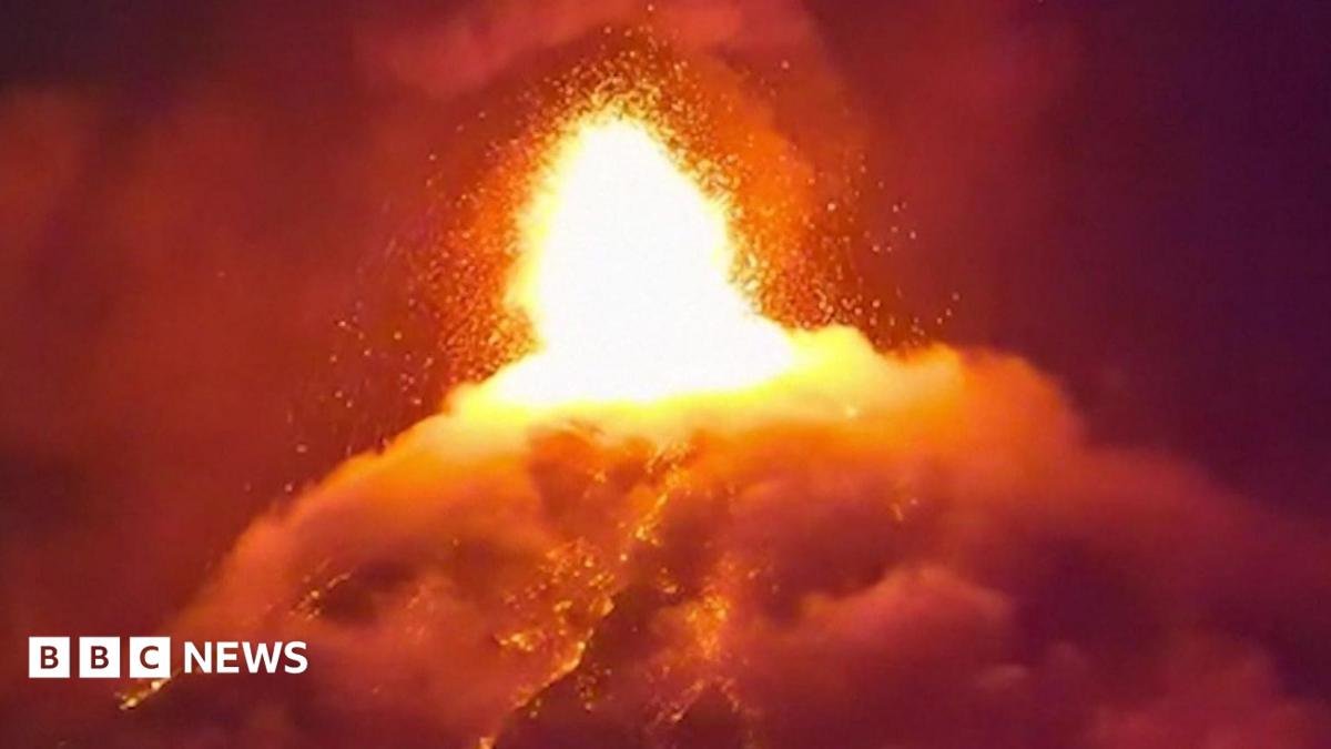
Fuego volcano erupted Monday, sending pyroclastic flows down its southeastern slope and prompting Conred's orange alert plus evacuation of two villages. Located 16km from Antigua, the activity echoes the 2018 Las Lajas disaster that killed over 200. Schools closed and hikers warned as monitoring...
Guatemala's Fuego Volcano Erupts, Forcing Evacuations
Guatemala City, Guatemala — article continues...
The Eruption
Fuego stratovolcano began spewing lava and ash on Monday, sending pyroclastic currents down its south-eastern slope early on Tuesday. The volcano, one of the most active in Central America, is located 16km west of Antigua and about 35km from Guatemala City. Government monitors reported that the flows of gas, volcanic ash and rock fragments continued to intensify through the night.
Pyroclastic flows consist of superheated gas mixed with volcanic fragments that surge down slopes at speeds exceeding one hundred kilometers per hour while temperatures can surpass five hundred degrees Celsius. At Fuego the steep southeastern flanks channel these currents with particular force as loose material from prior eruptions adds fuel to each new surge.
Evacuations and Orange Alert
Disaster management agency Conred issued a nationwide orange alert on Monday evening, the second-highest level, and began evacuating at least two villages on the volcano's slopes. Officials urged residents to keep windows and doors closed and cancelled classes in schools near the volcano to reduce exposure to ash.
Conred warned that further pyroclastic flows and billowing ash clouds could develop, directing people to stay away from high-risk zones. In Guatemala the national disaster agency works through departmental and municipal committees that activate when an orange alert is declared, coordinating with mayors to open temporary shelters in schools or community halls.
At the orange alert level Conred directs residents in designated high-risk zones to prepare for possible evacuation by gathering essential documents, medications and a change of clothing while securing livestock and closing homes against ash. Families receive instructions through community loudspeakers and door-to-door visits by local civil-protection committees that operate under municipal authority.
Shelters are established in school buildings and community halls by municipal staff working with Indigenous community leaders who organize transport using available pickup trucks and buses along narrow slope roads. Evacuation teams prioritize remote hamlets first, moving residents in stages to avoid congestion on single-access routes while maintaining contact with departmental coordinators for supply deliveries of water, food and medical kits.
Pyroclastic Flows: The Deadliest Threat
Pyroclastic currents remain the primary concern, as these fast-moving mixtures of gas and debris can reach high speeds and temperatures. Monitors stated that flows continued down the south-eastern slope on Tuesday, prompting repeated warnings against approaching the volcano.
The 2018 tragedy along the Las Lajas ravine illustrated this destructive power when flows overtook villages before residents could reach safety. Monitoring agencies now track Fuego through networks of seismic stations that detect ground tremors, gas sensors measuring sulfur dioxide spikes and satellite imagery that reveals thermal anomalies often hours before visible flows begin.
Following the 2018 Las Lajas flows that overtook communities before full evacuation could occur, official reviews identified gaps in alert timing and public awareness that contributed to the loss of more than 200 lives. Subsequent changes included installation of additional seismic stations nearer the summit, expansion of community radio networks for immediate voice alerts and introduction of regular evacuation drills in villages along known flow paths.
Pyroclastic flows travel at speeds exceeding one hundred kilometers per hour while carrying temperatures above five hundred degrees Celsius, filling ravines with a mixture of gas and rock fragments that can incinerate or bury anything in their path. Because these currents follow topography and can change direction with minor shifts in vent activity, monitoring focuses on detecting early increases in ground vibration and gas output that often precede visible surges.
A Volcano on Antigua's Doorstep
Antigua, a UNESCO World Heritage Site known for its colonial architecture, sits just 16km from Fuego. The city draws tourists from across Latin America and beyond, many of whom also hike the volcano's slopes. Conred explicitly told visitors and locals to avoid risk areas, including the volcano itself.
Antigua's status draws visitors whose spending supports hotels and markets, yet proximity to Fuego introduces recurring disruptions. When ash clouds rise, flights at La Aurora airport in Guatemala City face delays or cancellations because volcanic particles can damage jet engines.
Tourism centered on Antigua generates revenue through hotels, guided hikes and markets that draw visitors year-round, yet ashfall from Fuego forces repeated cancellations and temporary closures that reduce income for operators dependent on clear access to the volcano slopes. Airlines at La Aurora airport in Guatemala City routinely delay or cancel flights when ash clouds drift over flight paths because abrasive particles can erode engine components.
The volcano's slopes support coffee plantations and subsistence crops whose fertile volcanic soils yield steady harvests, but heavy ash deposits can strip leaves, contaminate water sources and delay picking schedules for weeks. Smallholder families weigh these recurring losses against the cost of relocating farther from the mountain, often choosing to remain and accept periodic disruptions rather than abandon established plots and community ties.
Lessons From 2018
More than 200 people died in Fuego's 2018 eruption, many overtaken by pyroclastic flows that raced down the Las Lajas ravine. That event remains Guatemala's most violent volcanic disaster in over a century and continues to shape how Conred prepares communities today.
Families displaced this week include descendants of those affected in 2018. Those events prompted upgrades including additional seismic stations closer to the summit, expanded community radio networks for real time alerts and regular evacuation drills in high risk villages.
Regional Resilience and What Comes Next
Guatemala's response this week reflects broader efforts across the Ring of Fire nations to balance daily life with volcanic risk. Conred's orange alert and school closures represent standard precautions, while the evacuation of two villages shows authorities acting before flows reach populated areas.
Whether the current activity produces additional major flows remains uncertain, but the pattern of Fuego's eruptions demonstrates that monitoring must continue without pause. For residents near Antigua and along the slopes, the coming days will test both official preparedness and the quiet endurance that defines communities living under active volcanoes.
By Elena Vasquez, Staff WriterConred and the national seismic institute will continue tracking seismic tremor rates, sulfur dioxide emissions and the height of any ash columns over the next several days to determine whether activity is intensifying or subsiding. An increase in long-period earthquakes or sudden spikes in gas output could prompt extension of the orange alert and additional evacuations from the two villages already cleared.
Evacuations in similar past events have lasted from several days to more than two weeks depending on whether flows remain confined to uninhabited ravines or threaten new areas. Authorities maintain daily assessments with input from field observers who report on ash thickness and any new vent openings before deciding on phased returns of residents to their homes.
By Elena Vasquez, Staff Writer
This article was produced with AI-assisted research and editorial support. Reporting is based on sources cited in the article.
What's Your Reaction?
 Like
0
Like
0
 Dislike
0
Dislike
0
 Love
0
Love
0
 Funny
0
Funny
0
 Wow
0
Wow
0
 Sad
0
Sad
0
 Angry
0
Angry
0

Latin America Correspondent at Global1.News. Based in Mexico City, covering politics, economics, energy, and culture across the region. Brings an on-the-ground perspective to stories spanning from the Rio Grande to Patagonia.














Comments (0)