
Tropical Storm Maymay (Kujira) Intensifies Near Luzon
Tropical Storm Maymay formed without much noise overnight, then crossed the threshold into a named system by Wednesday morning. What started as a low-pressure area west of La Union now sits close enough to Luzon to trigger wind signals and prolonged rain across multiple regions. Folks, the slow pace is the real problem here.
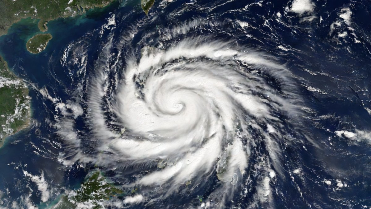
Tropical Storm Maymay formed without much noise overnight, then crossed the threshold into a named system by Wednesday morning. What started as a low-pressure area west of La Union now sits close enough to Luzon to trigger wind signals and prolonged rain across multiple regions. Folks, the slow pace is the real problem here.
Tropical Storm Maymay Intensifies, Luzon Signals Raised
Manila, Philippines — PAGASA reported that a low-pressure area west of La Union developed into Tropical Depression Maymay late Tuesday, August 4, 2026, according to the 11:00 PM advisory. By 2:00 AM Wednesday the system strengthened into a tropical storm and received the international name Kujira. At 5:00 AM the center was located about 170 km west-northwest of Bacnotan, La Union, with maximum sustained winds of 65 kph and gusts up to 80 kph.
Maymay's Rapid Timeline From Depression to Storm
The system began as a low-pressure area west of La Union. PAGASA's 11:00 PM bulletin Tuesday confirmed it had organized enough to be classified as Tropical Depression Maymay, with the center 130 km west-northwest of Bacnotan, La Union. Overnight the circulation tightened and winds increased.
At 2:00 AM Wednesday the depression reached tropical-storm strength. Japan contributed the name Kujira, meaning whale. The storm moved slowly, nearly stationary at times before shifting southeastward at a crawl. This path kept the center over open water but within range of Luzon coastal provinces.
By the 5:00 AM Wednesday bulletin the center had drifted to 170 km west-northwest of Bacnotan. Maximum sustained winds stood at 65 kph with gusts to 80 kph. The slow motion meant the same areas faced repeated exposure to rain bands rather than a quick pass.
Wind Signals Now Cover Parts of Luzon
PAGASA first hoisted Tropical Cyclone Wind Signal No. 1 over 17 areas of Luzon while Maymay was still a depression. After the upgrade to tropical storm, Signal No. 2 was raised over six Luzon areas. Benguet remained under Signal No. 1.
Signal No. 1 means winds of 39-61 kph are possible within 36 hours, enough to damage light structures and bring down tree branches. Signal No. 2 indicates winds of 62-88 kph within 24 hours, raising the risk of damage to roofs and power lines. Residents in these zones should secure outdoor items and prepare for possible power interruptions.
The signals focus on northern and central Luzon provinces closest to the storm's projected path. Forecasters noted that even these modest wind speeds can combine with heavy rain to create additional hazards such as falling debris and localized flooding.
Extended Rain Threat From Maymay and the Habagat
Maymay is already delivering moderate to intense rain over Northern Luzon and Central Luzon. The storm's slow movement increases the chance that rainfall totals will build over successive hours rather than a single burst. Mountainous terrain in these regions faces elevated risk of rain-induced landslides.
The southwest monsoon, or habagat, is being enhanced by the storm. This interaction is producing moderate to heavy rain in portions of Southern Luzon and Western Visayas even though those areas sit farther from the center. The combined effect spreads the rain footprint well beyond the storm's immediate circulation.
Prolonged rainfall is the primary concern. Forecasters warned that the near-stationary behavior could keep rain bands parked over the same watersheds for an extended period, raising flood levels in low-lying communities and saturating slopes already soaked from earlier monsoon activity.
The southwest monsoon, known locally as the habagat, draws moist air from the ocean across the Philippines during August. When a tropical storm like Maymay lingers offshore, its circulation strengthens this flow, pushing rain bands far beyond the storm center into Southern Luzon and Western Visayas. The interaction turns isolated showers into widespread, persistent downpours that can last for days rather than hours.
Low-lying river basins across Central and Northern Luzon are especially prone to flooding under these conditions. Water levels rise steadily as repeated rain bands feed the same watersheds, overwhelming drainage systems and turning fields into lakes. Rice crops and other August plantings suffer when fields remain submerged, delaying harvests and damaging root systems already stressed by the season's typical monsoon pattern.
Mountain slopes in these regions absorb the excess moisture until saturation triggers landslides. The slow storm motion means rainfall totals accumulate without relief, pushing even modest systems into major flood producers when they stall near the coast.
Landfall Outlook and Typhoon Dolphin Monitoring
Landfall remains possible within the day over Ilocos Sur. The storm's slow southeastward drift keeps the Ilocos region in the crosshairs while the center stays offshore. Any slight acceleration could shift the timing, but current motion suggests the coast will feel effects before the system moves inland or recurves.
PAGASA continues to track Typhoon Dolphin, which remains outside the Philippine Area of Responsibility. The agency is watching whether Dolphin will influence Maymay's track or intensity later in the week. For now the two systems are separate, but long-range steering patterns will determine if interaction develops.
Residents should monitor updates because even small changes in forward speed can alter rainfall duration along the western coast. The current forecast keeps the focus on the immediate rain and wind impacts rather than rapid intensification.
A slow southeastward drift keeps the storm's rain bands trained over the same coastal stretches for longer periods. This motion reduces the window for the system to move away quickly, but it also introduces uncertainty because small shifts in steering currents can alter the exact timing or location of any approach to Ilocos Sur. Forecasters must weigh multiple model runs to narrow the possibilities.
Recurvature remains a key watch point. If upper-level winds turn the storm northward or eastward before landfall, the threat to Luzon could ease, yet the same currents might draw Typhoon Dolphin closer to the Philippine Area of Responsibility. PAGASA coordinates with regional centers to monitor these steering patterns and update advisories as data arrives.
Even without direct interaction, Dolphin’s presence can influence Maymay’s track through broader atmospheric changes. Residents along the western coast should treat the current outlook as fluid and check updates frequently rather than assume a fixed path.
Why a Slow, Modest Storm Still Poses Serious Risks
Maymay's winds top out at only 65 kph, yet the storm's lack of forward motion multiplies the threat. Repeated rain bands over the same ground can exceed what a faster-moving stronger system might deliver in a single pass. Northern and Central Luzon have already seen how extended downpours turn minor streams into flood channels.
Landslide risk rises sharply in the Cordillera and other mountainous zones when rainfall lingers. Saturated soil loses cohesion, and even moderate winds can topple weakened trees onto roads and power lines. The combination of Signal No. 2 winds and ongoing rain creates compound hazards that exceed the individual components.
The enhanced habagat adds another layer. Areas south of the center receive heavy rain without direct storm passage, stretching emergency resources across a wider geography. This pattern has produced significant flooding in past seasons when similar slow systems interacted with the monsoon.
Wind speed alone does not determine a storm’s impact. A slow-moving system like Maymay allows rain bands to pass repeatedly over the same terrain, building totals that exceed what a faster, stronger typhoon might deliver in one sweep. Saturated ground then loses its ability to absorb more water, turning moderate rainfall into flash floods and swollen rivers.
The Cordillera’s steep slopes become especially hazardous once soil reaches saturation. Even modest winds can dislodge trees and debris onto roads while loosened earth gives way in landslides. Urban areas near Metro Manila face similar compounding risks if the enhanced monsoon extends heavy rain into low-lying neighborhoods already vulnerable to drainage overload.
Communities often underestimate systems labeled “weak.” Past seasons show that dismissing a slow tropical storm leads to delayed preparations, leaving residents exposed when accumulated rain overwhelms defenses that would have held against quicker events.
Immediate Steps Residents Must Take
Check local government announcements for evacuation orders in flood-prone and landslide-susceptible barangays. Secure roofing, clear drainage canals, and move valuables to higher ground before additional rain arrives. Families in Signal No. 2 areas should ready flashlights, backup power, and a go-bag in case lines go down.
Stay tuned to official PAGASA bulletins rather than unverified social-media claims. The storm's slow progress means conditions can change gradually but steadily, so hourly updates matter. Communities in Western Visayas and Southern Luzon should also prepare for habagat-enhanced rainfall even if winds stay light.
Local disaster offices have already activated response teams. Residents who follow the signals and rainfall advisories now will reduce exposure when the heaviest bands arrive. Action taken in the next few hours determines how much damage the prolonged rain ultimately causes.
By Jessica Ali, Staff Writer
Barangay officials and local government units coordinate with the NDRRMC to issue targeted evacuation orders for flood- and landslide-prone zones. Residents should act on these alerts immediately, securing roofs, clearing drains, and moving livestock and valuables to higher ground before water rises. A prepared go-bag with documents, medicines, flashlights, and extra batteries ensures families can move quickly if power fails or roads close.
Monitoring PAGASA bulletins through official channels provides the most reliable updates on signals and rainfall. Checking on neighbors, especially the elderly and those with mobility issues, spreads awareness and reduces isolation during prolonged events. Early action at the household and community level prevents the need for larger rescues once the heaviest bands arrive.
Protecting important papers in waterproof containers and having a plan for pets and farm animals limits losses that compound after the rain stops. Waiting until conditions worsen leaves fewer safe options and stretches already activated response teams.
This article was produced with AI-assisted research and editorial support. Reporting is based on sources cited in the article.
What's Your Reaction?
 Like
0
Like
0
 Dislike
0
Dislike
0
 Love
0
Love
0
 Funny
0
Funny
0
 Wow
0
Wow
0
 Sad
0
Sad
0
 Angry
0
Angry
0

Editor-in-Chief at Global1.News. Atlanta-based journalist who cuts through the BS and tells it like it is. Lead anchor, host, and the voice you hear when the spin stops and the truth starts.













Comments (0)