
Hurricane Rachel Strengthens Again Off Baja as Its Moisture Feeds a 30-State Flood Threat
Hurricane Rachel held Category 2 strength off Mexico's Baja California peninsula on Sunday, keeping five ports closed and Los Cabos beaches under black flags, while US forecasters warned its moisture would help drive a week-long flood threat across more than 30 states.
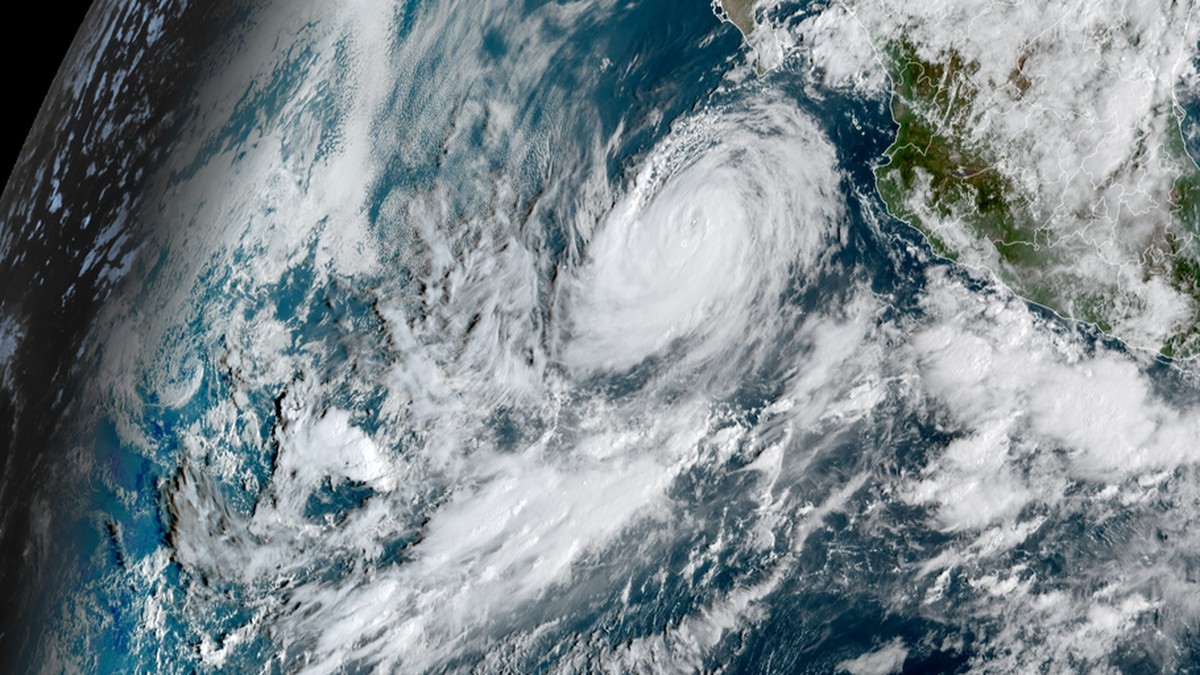
Hurricane Rachel is churning off Mexico's Baja California peninsula as a Category 2 storm, its outer bands still driving heavy seas against a coastline where five ports are shut and the beaches fly black flags. The National Hurricane Center expects Rachel to begin weakening on Monday, but its moisture is already feeding a flood threat hundreds of miles to the north, across more than 30 US states. In Mexico, officials report no deaths from the storm, even as high water has damaged roads, restaurants and homes from Baja California Sur to Colima.
Hurricane Rachel Strengthens Again Off Baja as Its Moisture Feeds a 30-State Flood Threat
Los Cabos, Mexico — Hurricane Rachel strengthened slightly overnight into Sunday, holding Category 2 strength well off the southern tip of the Baja California peninsula, as Mexican authorities kept five ports closed and US forecasters warned that the storm's moisture would help drive a week-long flood threat across more than 30 states. The National Hurricane Center in Miami said Rachel's centre was about 280 miles (455 km) south-west of Cabo San Lucas at 2 a.m. Mountain Standard Time, with maximum sustained winds of 100 mph (155 km/h) and a minimum central pressure of 968 millibars. No coastal watches or warnings were in effect. The storm was moving west-north-west at 5 mph (7 km/h), a track that keeps its core at sea.
Where Rachel Stands
In Advisory 29, issued at 2 a.m. MST Sunday (0900 UTC), the National Hurricane Center placed Rachel's centre near latitude 20.2 North, longitude 113.2 West, roughly 280 miles (455 km) south-west of the southern tip of Baja California. Maximum sustained winds were 100 mph (155 km/h), making Rachel a Category 2 hurricane, with higher gusts and a minimum central pressure of 968 millibars. The storm was moving west-north-west, or 295 degrees, at 5 mph (7 km/h). Forecasters expect a turn toward the west later on Sunday, then a westward motion with some increase in forward speed through Tuesday. Hurricane-force winds extend outward up to 45 miles (75 km); tropical-storm-force winds reach up to 140 miles (220 km). Forecaster Beven wrote that fluctuations in strength are possible through Sunday night, and that Rachel is expected to slowly weaken starting Monday.
A Storm That Strengthened, Weakened, Then Strengthened Again
Rachel's intensity has swung in both directions over four days. It peaked as a Category 3 hurricane briefly on Thursday 1 October, with sustained winds near 120 mph (195 km/h) and a minimum pressure of 950 millibars, and was still a major hurricane on Friday 2 October. Mexico's Servicio Meteorologico Nacional reported Rachel was downgraded to Category 1 on Saturday 3 October while still producing very heavy rain, strong gusts and high seas in Baja California Sur. By 0300 UTC on Sunday, the National Hurricane Center's Advisory 28 was headlined "Rachel Strengthens Slightly as It Continues West-North-Westward," with winds back to 90 mph (145 km/h) and pressure at 970 millibars. That discussion said Rachel could be at the early stage of acquiring structural characteristics typical of an annular hurricane, which could temper any weakening, and that some re-intensification was possible through 72 hours before drier air and cooler sea-surface temperatures take over.
Why the Coast Was Spared a Landfall
Rachel has stayed at sea because of where it sits and where it is going. Its west-north-westerly heading of 5 mph (7 km/h) carries the core away from the peninsula rather than toward it, and the forecast shows no inland track within the 120-hour window. The hazards that do reach land are generated at a distance. Swells will continue to affect the coast of west-central Mexico through the weekend and the Baja California Peninsula through Monday, conditions the hurricane centre describes as likely to cause life-threatening surf and rip current conditions. Mexico's Servicio Meteorologico Nacional reported waves of 3 to 4 metres on the Baja California Sur coast and 2 to 3 metres on the coasts of Sinaloa, Nayarit, Jalisco and Colima. GDACS, the Global Disaster Alert and Coordination System, rated Rachel-26 overall green, meaning low humanitarian impact, based on maximum sustained wind speed, exposed population and vulnerability. It recorded a maximum wind speed of 194 km/h, a maximum storm surge of 0.3 metres, and an exposed population in Category 1 or higher of no people.
Ports Closed, Beaches Black-Flagged, Schools Shut
Mexico's Secretariat of the Navy ordered maritime closures that shut five ports in Baja California Sur. Total closure for smaller vessels was ordered at the bays of La Paz, Los Barriles, Cabo San Lucas, San Jose del Cabo and San Carlos in Baja California Sur, and for smaller fleets at Teacapan and Mazatlan in Sinaloa, San Blas and Nuevo Vallarta in Nayarit, and Puerto Vallarta in Jalisco. Restrictions on larger vessels applied at Mazatlan and San Blas. At Cabo San Lucas the port captain closed the port to all nautical activities, and several major cruise lines rerouted their ships and skipped planned Los Cabos stops this week; Cabo San Lucas is a tender port, where large ships anchor offshore and shuttle passengers in on small boats. The US Embassy in Mexico said the port had been closed since Wednesday 30 September until further notice, with all beaches shut and black flags posted from 2 p.m. local time that day, warning that similar ocean conditions have caused deadly rip currents and rogue waves that have killed US citizens. In Los Cabos, the State Civil Protection Council decreed the total suspension of classes at all levels, both shifts, on Thursday 1 October; school campuses in seven municipalities of Michoacan's Sierra Costa region suspended classes the same day.
Flooding from Baja California Sur to Colima
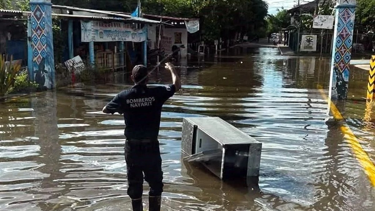
Rachel has already come ashore in the form of water. Agencia Reforma and El Diario de Chihuahua reported that the storm caused heavy seas, waves up to 3 metres, and flooding in main roads and businesses along the coastal strip of Baja California Sur, Nayarit, Sinaloa and Colima. Mexico's Servicio Meteorologico Nacional forecast very heavy rainfall of 50 to 75 mm in Baja California Sur and warned the rain could cause landslides, rising river and stream levels, overflow and flooding in low-lying zones, urging residents to follow official advisories. Not every forecaster agrees on the totals: TravelPulse reported some areas around Los Cabos could receive 70 to 75 mm, while Debate reported forecasts of 75 to 150 mm in the state. Colima's Civil Protection unit reported no casualties, a "saldo blanco," but confirmed material damage to coastal infrastructure, restaurants and homes from the sea swell in Tecoman, Armeria and Manzanillo, and the port of Manzanillo remained closed to major navigation. In Sinaloa the sea overflowed, flooding the malecon and streets of Teacapan in Escuinapa municipality, the Altata residential zone in Navolato, and the community of El Colorado in Ahome.
When the Sea Came Over the Wall in San Blas
In Nayarit, the combination of high tide and storm surge pushed the sea over the beach line at the port of San Blas, sending water into main roads and onto the San Blas-Matanchén highway, according to Tribuna de Mexico. The Secretariat of the Navy's closures reflected those conditions: total closure for smaller vessels at San Blas and Nuevo Vallarta, and restrictions on larger vessels at San Blas. The Servicio Meteorologico Nacional had forecast waves of 2 to 3 metres on the Nayarit coast, part of a band of high seas running from Sinaloa through Jalisco and Colima. Civil Protection in Sinaloa posted red flags on the beaches and closed the ports to minor navigation, and in Mazatlan the heavy swell damaged coastal palapas, while Colima reported material damage but no casualties from the surge along its coast.
The Flood Threat Six Hundred Miles North
The same storm is being felt far from its own winds. Fox Weather reports that a week-long flash flood threat is spreading from the South-west of the United States into the Plains and Midwest, eventually stretching from Texas to Minnesota and putting more than 150 million people at risk. A Flood Watch covers 12 states, with more expected to be added. Moisture from Hurricane Polo is fuelling the threat across the South-west and Central US through Wednesday; moisture from Rachel picks it up across Texas, the Southern Plains and the Midwest from late Wednesday through Friday. Nearly 80 trillion gallons of water could fall during the week. Dallas has not seen measurable rain since 16 July, leaving ground that cannot absorb much. A Level 3 out of 4 flash flood risk covered over 230,000 square miles across parts of southern and eastern Arizona, much of New Mexico, southern Colorado, the Texas and Oklahoma Panhandles and south-western Nebraska.
A Record-Breaking Pacific Season
Rachel became the eighth major hurricane of the eastern Pacific season, against an average of five in El Nino years since 1990, according to Fox Weather, which counts Rachel as the 20th named storm and the 10th hurricane in the Central and Eastern Pacific this season. The same season produced Hurricane Polo, which reached Category 5 strength three times with peak winds of 180 mph and is the second-most intense hurricane on record by central pressure at 892 millibars, behind Hurricane Patricia's 872 millibars in 2015. Polo made landfall on Baja California Sur as a Category 2 storm late on Monday 29 September, then made a second landfall as a hurricane in mainland Mexico on Tuesday. Landfalls on Baja California are rare; the previous one was Norma in October 2023. Polo became only the 10th remnant tropical storm or hurricane to survive the trip over the mountains and affect the United States since 1950.
Streets Turned to Streams in San Jose del Cabo
The damage in Los Cabos has come from rain rather than wind. On the afternoon of Saturday 3 October, heavy rain and wind flooded main roads and turned streets into streams in the Luis Donaldo Colosio and Colinas de San Jose neighbourhoods of San Jose del Cabo, washing sediment onto the main avenues, according to Tribuna de Mexico. Beaches throughout Los Cabos remained under black-flag conditions, and officials said some areas could receive between 70 and 75 mm of rain, with four temporary shelters activated as a precaution. Emergency personnel responded to incidents involving people trapped in arroyo channels. No deaths have been reported in Mexico from the storm; Colima's Civil Protection unit recorded none, and no other state has published a fatality figure.
What Comes Next for Rachel
The National Hurricane Center expects Rachel to turn toward the west later on Sunday, then continue westward with some increase in forward speed through Tuesday, with fluctuations in strength possible through Sunday night and slow weakening starting Monday. Advisory 28 noted that Rachel could be at the early stage of acquiring characteristics typical of an annular hurricane, which could temper any weakening, and that some re-intensification was possible before drier air and cooler seas take over. No coastal watches or warnings are in effect, and the forecast shows no inland track within the 120-hour window. GDACS rates Rachel-26 overall green, with a maximum storm surge of 0.3 metres. For now the closures hold: five Baja California Sur bays and the five Pacific ports open only to larger vessels, the port of Cabo San Lucas shut to all nautical activity, and the beaches of Los Cabos still flying black flags.
By Jessica Ali, Staff Writer
This article was produced with AI-assisted research and editorial support. Sources: National Hurricane Center, Fox Weather, Servicio Meteorologico Nacional (Mexico), Agencia Reforma, El Diario de Chihuahua, CodigoQro, Tribuna de Mexico, TravelPulse, Cabo Sun, U.S. Embassy in Mexico, GDACS.
What's Your Reaction?
 Like
0
Like
0
 Dislike
0
Dislike
0
 Love
0
Love
0
 Funny
0
Funny
0
 Wow
0
Wow
0
 Sad
0
Sad
0
 Angry
0
Angry
0

Editor-in-Chief at Global1.News. Atlanta-based journalist who cuts through the BS and tells it like it is. Lead anchor, host, and the voice you hear when the spin stops and the truth starts.













Comments (0)