
Fuego Volcano Erupts Forcing Evacuations in Guatemala
Fuego volcano erupts in Guatemala, forcing the evacuation of two villages as pyroclastic flows and ash clouds prompt a nationwide orange alert. Schools near Antigua closed as officials recall the volcano's deadly 2018 eruption.
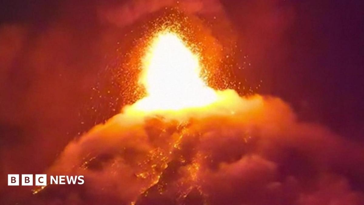
Fuego Volcano Erupts Forcing Evacuations in Guatemala
The Fuego volcano has once again reminded Central America of its raw power, sending lava and ash skyward and forcing the immediate evacuation of at least two villages on its slopes. One of the Western Hemisphere's most active volcanoes, Fuego began its latest phase of activity on Monday, with dangerous pyroclastic currents continuing to move down its south-eastern flank early on Tuesday. Government agencies are now racing to protect residents while urging caution across a wider area that includes popular tourist routes near Antigua. The situation highlights ongoing challenges for communities living in the shadow of active volcanoes throughout Latin America.
Guatemala City, Guatemala — The eruption of the Fuego volcano in Guatemala has triggered the evacuation of at least two villages on its slopes. Fuego, one of the most active volcanoes in the Western Hemisphere, started spewing lava and ash on Monday. Pyroclastic currents continued to flow down Fuego's south-eastern slope early on Tuesday, the government agency which monitors its activity said.
Eruption Timeline and Village Evacuations
Fuego began its current eruptive phase on Monday, sending lava and ash into the air above its slopes. The activity quickly prompted authorities to order the evacuation of at least two villages located directly on the volcano's flanks. Residents moved to safer ground as the threat of further flows developed throughout the day and into the night.
Early on Tuesday, pyroclastic currents of gas, volcanic ash and rock fragments continued moving down the south-eastern slope. These fast-moving currents pose the greatest immediate danger to any remaining people or property in their path. Evacuation efforts focused on clearing vulnerable areas before conditions could worsen.
Local officials coordinated the movement of families from the affected villages, ensuring they had access to temporary shelter. The response reflects standard procedures developed after previous eruptions in the region. Communities in Guatemala and neighboring countries understand the need for rapid action when Fuego shows signs of increased activity.
Nationwide Orange Alert Issued by Conred
Guatemala's disaster management agency Conred raised the alert level to nationwide orange status, the second highest category. This step signals that further pyroclastic flows and billowing ash clouds remain possible in the coming hours and days. Conred issued clear instructions for residents to keep windows and doors closed to limit exposure to ash.
Schools near the volcano cancelled classes as a direct precaution. The measure protects students and staff from potential ashfall and sudden changes in conditions. Conred also advised the public to stay informed through official channels rather than relying on unverified reports.
The orange alert applies across Guatemala, underscoring that volcanic hazards can affect areas beyond the immediate slopes. Preparation includes checking emergency supplies and knowing evacuation routes. Such steps have become routine for populations living near active volcanoes in Central America.
In Central American nations prone to seismic and volcanic activity, alert systems typically progress through color-coded stages that signal increasing levels of threat, allowing authorities to coordinate responses across multiple agencies. An orange designation, positioned as the second-highest level, serves as a critical escalation that prompts heightened monitoring and community readiness measures without yet triggering full-scale evacuations. Residents in affected zones often assemble emergency supplies, secure their homes against ashfall, and follow directives to limit outdoor exposure, reflecting a framework refined through years of adapting to recurring natural hazards in the region.
Guatemala's disaster management approach has incorporated lessons from past events to strengthen inter-agency communication and public outreach, emphasizing the role of local communities in executing timely protective actions. School closures and instructions to seal buildings against airborne particles represent practical applications of these protocols, aimed at minimizing health risks from volcanic emissions. Such measures underscore an evolving emphasis on proactive steps that balance daily life continuity with safety imperatives in volcanically active landscapes.
Over time, the nation's framework has shifted toward integrating real-time data from monitoring stations with community education campaigns, fostering greater compliance during alert periods. This evolution highlights how Central American countries have worked to embed disaster preparedness into governance structures, ensuring that warnings translate into tangible behaviors like restricted travel and resource stockpiling. The approach draws on shared regional experiences to enhance resilience against sudden geological events.
Proximity to Antigua Raises Tourism Concerns
Fuego sits just 16 kilometers west of Antigua, the colonial city that draws thousands of visitors each year to its Unesco World Heritage Site. Tourists come to admire the historic architecture and many also hike on the volcano's slopes. The current eruption has forced authorities to warn both visitors and locals against approaching or remaining in high-risk zones.
Conred specifically cautioned against travel to the volcano's slopes, where conditions can change rapidly. Hikers and tour operators have been told to avoid the area until the alert level drops. Antigua itself has not reported direct impacts so far, yet the proximity keeps the city on edge.
The situation affects local economies that depend on tourism while also testing emergency plans designed to balance safety with continued access to popular sites. Regional travelers from countries such as Brazil and Mexico often include Antigua on their itineraries, making the volcano's behavior relevant far beyond Guatemala's borders.
Antigua's status as a cultural hub draws visitors eager to explore its colonial architecture and nearby natural wonders, creating an economy where tourism revenue supports countless local livelihoods tied to guiding services and hospitality. The presence of an active volcano nearby introduces ongoing tensions, as operators must navigate advisories that discourage hikes while preserving the appeal that sustains businesses. When activity prompts restrictions, the ripple effects extend to artisans, transport providers, and markets that depend on steady visitor flows.
Local economies in such settings often balance the allure of volcanic landscapes with the need for prudent risk communication, advising tour groups to monitor updates and avoid high-risk trails during elevated alerts. This dynamic mirrors challenges faced in other Latin American destinations where iconic sites sit amid geological hazards, requiring flexible strategies that protect both people and prosperity. Economic pressures intensify when cancellations mount, highlighting the vulnerability of communities built around seasonal tourism.
Wider implications emerge as prolonged uncertainty around access to popular attractions can deter international bookings, affecting not only immediate operators but also broader supply chains in Guatemala's western highlands. Regional examples from Ecuador and Chile demonstrate similar negotiations between heritage preservation and safety, where sustained investment in alternative attractions helps mitigate downturns. These patterns reveal the intricate ties between natural risk and economic stability in tourism-dependent areas across the Americas.
Echoes of the Deadly 2018 Eruption
More than 200 people died when Fuego erupted in 2018, many caught in pyroclastic flows that raced down the Las Lajas ravine. That tragedy remains a reference point for current response efforts. Authorities are applying lessons learned to limit exposure this time around.
The 2018 disaster showed how quickly pyroclastic currents can travel and how difficult they are to outrun. Today's evacuations of two villages aim to prevent similar losses. Conred continues to stress that staying away from the slopes is the most effective protection.
Fuego's history of sudden, intense activity means residents and officials treat every new phase seriously. The volcano's location in a densely populated part of Central America requires constant vigilance. Past events have shaped stronger coordination between monitoring agencies and local communities across the region.
The 2018 eruption exposed critical gaps in how rapidly moving flows could overwhelm settlements along steep ravines, prompting a reevaluation of evacuation routes and timing across Guatemala's volcanic corridors. That event fundamentally altered monitoring priorities, leading to more frequent assessments and refined thresholds for issuing alerts that prioritize early movement of vulnerable populations. Communities near the slopes have since internalized these changes, viewing current warnings through the lens of collective experience that prioritizes caution over complacency.
Memory of the devastation along specific drainage paths continues to influence daily decision-making, with residents more attuned to subtle changes in activity reported by scientific agencies. This historical imprint has driven investments in clearer communication channels between officials and rural households, ensuring that alerts prompt swift, organized responses rather than hesitation. The reshaping of protocols reflects a broader commitment to preventing similar tragedies through sustained vigilance and adaptive planning.
In the years following, Guatemalan authorities have emphasized rebuilding trust in warning systems by incorporating survivor perspectives into training exercises and public drills. Such efforts acknowledge that community memory serves as both a motivator for preparedness and a reminder of the human costs when flows descend unexpectedly. This ongoing process strengthens the social fabric of disaster response in areas where volcanic activity remains a persistent reality.
Implications for Regional Disaster Preparedness
Guatemala's response to Fuego offers lessons for other Latin American nations that face similar volcanic and seismic risks. Countries such as Mexico, Ecuador and Chile maintain their own monitoring networks and alert systems. Effective communication between agencies like INSIVUMEH and Conred demonstrates the value of clear, timely warnings.
Brazil, though not volcanic, shares the broader challenge of preparing for extreme natural events linked to shifting climate patterns. Heavy rains, landslides and flooding increasingly test infrastructure across the continent. Coordinated regional approaches to early warning and evacuation can reduce casualties when hazards strike.
Investments in public education, school safety protocols and restrictions on access to danger zones have become standard practice. These measures reflect a growing recognition that disaster preparedness must account for both sudden eruptions and longer-term environmental pressures affecting the entire region.
Volcanic hazards across Latin America demand coordinated monitoring networks that span borders, as seen in collaborative efforts among nations facing similar threats from the Andean chain and Central American arc. Countries like Mexico and Colombia maintain extensive surveillance of their own peaks, sharing data and best practices that enhance early detection capabilities continent-wide. These interconnections allow for more effective resource allocation during crises, illustrating how regional partnerships amplify individual nations' abilities to safeguard populations.
Brazil's disaster landscape, dominated by floods, landslides, and prolonged droughts in regions such as the Northeast and Southeast, offers contrasting yet complementary lessons in community-based preparedness that can inform volcanic response strategies elsewhere. While Brazil invests heavily in hydrological early-warning systems, exchanges with Andean and Central American counterparts highlight transferable elements like public education on evacuation signals. Such cross-regional dialogue fosters a more unified continental approach to reducing loss of life from diverse natural threats.
Ultimately, effective early-warning coordination and sustained public awareness campaigns have proven vital in saving lives throughout Latin America, where geological instability intersects with densely populated areas. By learning from varied national experiences, governments strengthen collective resilience, ensuring that alerts lead to decisive actions across diverse cultural and economic contexts. This shared emphasis on education and infrastructure underscores the continent's ongoing adaptation to its dynamic environment.
Monitoring the Situation Moving Forward
INSIVUMEH continues to track Fuego's activity and will update conditions as new data emerges. Conred stands ready to adjust the alert level if pyroclastic flows or ash emissions increase. Residents in nearby areas are advised to remain prepared while following official guidance.
Authorities have made clear that further evacuations could occur if the situation deteriorates. The focus remains on protecting lives through proactive measures rather than reactive rescues. Tourists planning visits to Antigua are encouraged to check current alerts before traveling.
The coming days will show whether Fuego's activity subsides or escalates. Regional observers will watch closely, knowing that effective management of this event can inform future responses across Latin America. Continued vigilance remains essential for all communities living near active volcanoes.
By Elena Vasquez, Staff WriterThis article was produced with AI-assisted research and editorial support. Reporting is based on sources cited in the article.
What's Your Reaction?
 Like
0
Like
0
 Dislike
0
Dislike
0
 Love
0
Love
0
 Funny
0
Funny
0
 Wow
0
Wow
0
 Sad
0
Sad
0
 Angry
0
Angry
0

Latin America Correspondent at Global1.News. Based in Mexico City, covering politics, economics, energy, and culture across the region. Brings an on-the-ground perspective to stories spanning from the Rio Grande to Patagonia.













Comments (0)