
Severe Thunderstorms Batter B.C., Sparking Wildfires and Grounding Flights at YVR
A powerful and rare thunderstorm system swept through British Columbia over the weekend, unleashing more than 7,000 lightning strikes, sparking dozens of new wildfires, and throwing Vancouver International Airport into a state of chaos that left hundreds of passengers stranded overnight.
Severe Thunderstorms Batter B.C., Sparking Wildfires and Grounding Flights at YVR
A powerful and rare thunderstorm system swept through British Columbia over the weekend, unleashing more than 7,000 lightning strikes, sparking dozens of new wildfires, and throwing Vancouver International Airport into a state of chaos that left hundreds of passengers stranded overnight.
The subtropical weather system moved onshore near Richmond on Saturday evening, bringing intense lightning, heavy rain, and wind that disrupted travel and tested emergency response systems across the province. While the precipitation helped dampen fire activity in some areas, officials are warning that the risk of new blazes is far from over as hot, dry conditions are expected to return this week.
Lightning Barrage Sparks New Wildfire Response
The B.C. Wildfire Service (BCWS) reported that the province experienced a significant lightning event between Saturday and Sunday, with more than 7,000 strikes recorded within a 24-hour period. The strikes were widespread, affecting all southern fire centres and creating a challenging environment for firefighting crews.
"There were lightning-caused wildfires in all southern fire centres yesterday after more than 7,000 strikes were recorded," the service said in its provincial situation report on Sunday. The BCWS confirmed that 57 new fires had started in the last 24 hours, with another 15 declared out during the same period. As of Sunday, there are 172 active wildfires burning across the province.
BCWS information officer Sarah Budd noted that the lightning was concentrated in specific regions. The Coastal Fire Centre recorded approximately 2,000 strikes, while another 5,000 were logged in the B.C. Interior, mostly in the Kamloops and Cariboo fire centres. Budd confirmed that lightning was responsible for at least 48 wildfires in the last 48 hours, though she noted that 60 per cent of those were already being held by crews.
The storm also delivered what Budd described as a "generous amount of precipitation" to many affected areas, helping decrease fire behaviour and reduce the likelihood of new starts after months of drought conditions.
"In anticipation of this pattern coming through, we had pre-positioned our crews and resources, just allowing for an efficient initial response to any new starts because we knew this was coming," Budd said. However, she cautioned that the rain was not enough to offset the province's underlying drought, and that new fires could yet emerge from lightning strikes that cause fuel to smoulder undetected for days before flames break out.
Airport Operations Grounded as Storm Hits South Coast
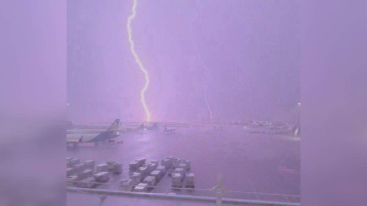
The same storm system created significant disruptions at Vancouver International Airport (YVR), where lightning forced a complete pause in operations for more than five hours. The airport confirmed that flights could not depart from 9:30 p.m. Saturday until 2:55 a.m. Sunday, as safety protocols prevented ground crews from working on the airfield during the electrical storm.
"Normally when we see something like that, it lasts for 20-30 minutes, operations get back to normal. Last night our operations were effectively paused," said YVR spokesperson Stephen Smart. "We can land aircraft during a storm like that, that's not a problem. But we can't have employees out on the airfield, we can't have aircraft taking off."
The airport was placed under a "red alert" during the storm, which meant nobody was working airside due to the threat of lightning. This left arriving aircraft unable to taxi to their gates, with a total of 39 aircraft waiting on the tarmac when the alert was finally lifted. Passengers on those planes were left stranded for hours, with little information coming from airport authorities.
"We were on the tarmac for four-and-a-half hours and there was very little to no information that was relayed to the pilot that was relayed to us, so they were struggling to get information from the airport authority," said David Cooper, a passenger who arrived on one of the affected flights.
For those who made it into the terminal, conditions were not much better. Simone McCallum described the scene as passengers were directed back to the check-in area for new boarding passes but were not allowed back through security, leaving them to sit or sleep on the hard floor.
"It was horrible, there was no place to stretch out at all, almost every surface where you could put yourself down was hard as rock," she said. "I can't even imagine what that would have been like with children, or if you had some kind of physical disability. It would have been just a complete nightmare."
Record Rainfall and Rare Thunderstorm Activity
The storm was notable not just for its lightning but also for its intensity. Environment and Climate Change Canada reported that the airport received 64 millimetres of rain during the event, more than double the precipitation YVR typically receives in the entire month of August. The worst of the deluge came between 10 and 11 p.m. Saturday, during which 22.2 millimetres were recorded.
Environment and Climate Change Canada meteorologist Gary Lee noted that the storm was a rare event for the region. The weather station at Vancouver International Airport, which has records dating back to 1911, sees an average of only 4.4 thunderstorm days per year. "It's pretty rare," Lee said, adding that because the storm peaked at night, both the sound of the thunder and the brightness of the lightning would have seemed more intense.
CBC meteorologist Johanna Wagstaffe described the system as "quite the system, hundreds of cloud to ground strikes ... mainly in Vancouver/Richmond." She explained that the centre of a low-pressure system pushed onshore near Richmond after travelling from the equator, loaded with moisture. A preliminary count from Environment Canada reported more than 1,800 incidences of lightning over the Lower Mainland alone on Saturday night and Sunday morning.
The storm also caused flooding inside the airport terminal, though officials said it did not impact operations. Social media was flooded with images and video of the dramatic lightning displays and heavy rain.
Power Outages and Ongoing Travel Disruptions
The severe weather also knocked out power for thousands of residents. B.C. Hydro reported numerous outages overnight, and as of Sunday morning, over 3,800 customers were without power in the Lower Mainland and Sunshine Coast regions.
The travel disruptions continued well into Sunday. YVR reported that more than 50 flights had been cancelled and at least 53 others were delayed as of Sunday afternoon. Airport officials activated their terminal response team and called in additional staff to support passengers during the overnight disruption.
"Although the weather has improved, some flights continue to be impacted today at YVR," the airport said in a statement on Sunday. "We are working closely with our airport partners to support recovery of their schedule and get passengers on their way as quickly as possible."
YVR's senior communications specialist, Megan Sutton, confirmed that departing flights were unable to leave the airport and arriving aircraft could not taxi to their gates, leaving some passengers stranded on planes for hours. Airport officials are advising travellers scheduled to fly Sunday to check their flight status before heading to the airport. Smart apologized to affected travellers, saying the airport called in extra staff as quickly as it could to help deal with the situation.
Looking Ahead: Holdover Fires and Returning Heat
While the immediate storm has passed, officials are warning that the threat of new wildfires remains elevated. The province cautions that hot, dry and windy conditions are expected to return this week, which could increase the potential for fire activity. These conditions could also lead to holdover fires, lightning-caused fires where heat smoulders undetected until hotter, drier and windier conditions lead to more visible smoke.
Environment Canada issued severe thunderstorm watches on Sunday for most of southeast B.C., including the Kootenays, Boundary and East Columbia regions, Arrow Lakes and beyond. The agency said an upper-level trough crossed southern B.C. overnight, bringing unstable atmospheric conditions that triggered numerous thunderstorms across the region.
The storm comes amid a challenging wildfire season for the province, which has experienced severe fire activity in recent years, including a devastating 2023 season. Months of drought conditions have been reported in parts of the province, and while the weekend rain provided some relief, officials stress that it was not enough to fully offset the dry conditions.
For residents and travellers, the weekend's events serve as a reminder of the increasing frequency of extreme weather events and the importance of preparedness. The BCWS is urging the public to report any signs of smoke or fire, as holdover fires could emerge in the coming days. With the return of hot, dry conditions expected later this week, the province remains on alert for new fire starts.
Tags: British Columbia, Vancouver, YVR, wildfires, lightning, thunderstorm, B.C. Wildfire Service, Environment Canada, travel disruption, power outage, climate, weather
This article was produced with AI-assisted research and editorial support. Sources: Global News, CBC News, CityNews Vancouver, CTV News.
By Alex Thompson, Staff Writer
What's Your Reaction?
 Like
0
Like
0
 Dislike
0
Dislike
0
 Love
0
Love
0
 Funny
0
Funny
0
 Wow
0
Wow
0
 Sad
0
Sad
0
 Angry
0
Angry
0

Canada Correspondent at Global1.News. Based in Toronto, covering Canadian politics, energy, trade, and US-Canada relations. Provides the Canadian perspective on North American and global affairs.














Comments (0)