
Cold Front Could Escalate B.C. Wildfires This Long Weekend
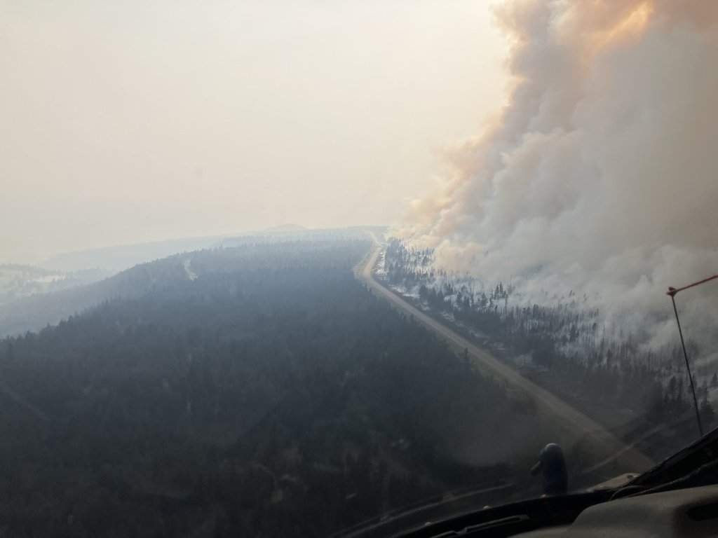
A cold front carrying strong winds and dry thunderstorms is forecast across southern British Columbia during the August long weekend, threatening communities facing multiple large wildfires. More than 1,800 properties remain under evacuation orders in the Thompson-Nicola and Cariboo regions.
Cold Front Could Escalate B.C. Wildfires This Long Weekend
A cold front carrying strong winds and dry thunderstorms is forecast to move across southern British Columbia during the August long weekend, increasing risks for communities already facing multiple large wildfires. The BC Wildfire Service has warned that the conditions will create challenging firefighting environments and could spark additional lightning-caused fires in tinder-dry forests. More than 1,800 properties remain under evacuation orders in the Thompson-Nicola and Cariboo regional districts as of August 1, 2026.
Tags: B.C. wildfires, Pear Lake fire, evacuation orders, BC Wildfire Service, August long weekend, cold front, southern British Columbia, T'it'q'et First Nation, Riley Creek wildfire, Thompson-Nicola regional district, Cariboo regional district, lightning caused fires
The Story
Vancouver, B.C. - Aug. 1, 2026 - Residents across southern British Columbia are preparing for a difficult August long weekend as a cold front approaches with the potential to intensify existing wildfires. Provincial authorities have already placed large areas under evacuation orders due to fires that have grown rapidly in recent days. The weekend coincides with the B.C. Day holiday, a period when many families travel within the province.
The approaching weather system follows patterns seen in past seasons where dry lightning and strong winds rapidly expanded fire perimeters. Residents in rural areas are checking emergency kits and monitoring the Alert Ready system, which has become a standard tool for rapid notifications during wildfire events. Highway travel through the Cariboo and Thompson-Nicola regions may face delays if visibility drops or if crews require road access for equipment movement.
The Pear Lake Fire
The Pear Lake wildfire, which merged with the Fiftynine Creek wildfire overnight on July 25-26 near Clinton, has expanded to more than 900 square kilometres. The combined fire is now managed as a single incident and has generated its own weather system. This scale has complicated efforts to protect nearby communities in the region.
Additional fires are also active. The Twin Two Creek wildfire near Lillooet, first identified on July 17, has reached more than 28 square kilometres. The Anderson Creek wildfire near Boston Bar, discovered in late July, has quadrupled in size amid steep terrain and heavy smoke that limit crew access.
Fire behaviour of this magnitude often produces pyrocumulonimbus clouds, which can generate their own lightning and wind patterns. Such self-reinforcing systems were observed during the record 2023 season that burned more than 2.8 million hectares across Canada. Beetle-killed and drought-stressed forests in the interior add fuel load, allowing fires to spread more quickly once winds increase.
Evacuations and First Nations Communities
Evacuation orders issued by the Thompson-Nicola and Cariboo regional districts cover an area more than 70 kilometres long and 65 kilometres wide, affecting more than 1,800 properties. Expanded orders now include locations such as Lillooet Lake Estates, Heather Jean Properties and the Strawberry Point recreation site around Clinton.
The T'it'q'et First Nation near Lillooet issued an overnight evacuation order for the Riley Creek Wildfire. The order applies to T'it'q'et Indian Reserve #2, Towinock and Indian Reserve #3, Kilchult. Such measures reflect the direct impact on Indigenous communities in the fire-affected zones.
First Nations emergency management teams often coordinate directly with provincial officials to support evacuees, drawing on established treaty relationships and community knowledge of the land. Past evacuations have shown that mental health support and culturally appropriate temporary housing remain important considerations for displaced residents. Provincial programs through the Ministry of Emergency Management and Climate Readiness provide frameworks for these coordinated responses.
Forecast and Firefighting Conditions
The BC Wildfire Service expects the incoming cold front to produce strong winds and thunderstorms that deliver little to no rain. These conditions are projected to fan out-of-control fires and increase the likelihood of new lightning-ignited blazes across tinder-dry landscapes in southern B.C.
Provincial data indicate nearly 110 active wildfires burning as of this morning, with 48 classified as out of control. Hundreds of firefighting personnel have been deployed province-wide to respond to the situation, though specific containment percentages remain unavailable at this time.
Dry lightning poses particular risks because strikes can ignite remote areas without accompanying moisture to suppress new starts. Fire crews must prioritise safety when winds accelerate flame spread, a lesson reinforced after the 2017 and 2018 seasons that set records for area burned in British Columbia. Officials continue to assess conditions hour by hour as the front moves through.
Canadian Context: A Long and Active Fire Season
British Columbia's wildfire response involves coordination between the BC Wildfire Service and regional districts, highlighting ongoing federal-provincial responsibilities in emergency management. First Nations reserves fall under distinct jurisdictional arrangements that require direct engagement during evacuations.
The current activity occurs against a backdrop of extended wildfire seasons influenced by drought and heat patterns across western Canada. Provincial emergency programs and disaster financial assistance frameworks are designed to support affected residents and communities during such events.
Comparisons to the 2021 destruction of Lytton and the 2024 Jasper wildfire in Alberta illustrate how quickly conditions can escalate in drought-stressed regions. These events have prompted ongoing investments in forest fuel management and inter-agency training. The Disaster Financial Assistance program remains available to eligible homeowners and businesses once fires are contained and damage assessments begin.
Impact on Canadians
Evacuation orders disrupt daily life for thousands of British Columbians, affecting access to homes, businesses and recreational areas during the long weekend. Tourism and forestry sectors face potential interruptions as roads close and air quality declines in smoke-affected zones.
Public safety measures, including emergency alerts and first-responder deployments, remain central to protecting residents. Community support networks and civic responsibility play key roles in helping evacuees navigate temporary relocations.
Air quality health index readings often rise sharply near active fires, prompting health advisories for vulnerable groups such as children and seniors. Campfire bans in provincial parks and restrictions on backcountry travel are standard during these periods to reduce ignition sources. Insurance providers typically advise policyholders to document property conditions before leaving evacuation zones.
What Happens Next
Officials will continue to monitor the cold front's progress and adjust firefighting strategies accordingly throughout the weekend. Expanded alerts may be issued if new fires ignite or existing ones spread further under windy conditions.
Residents in affected areas are advised to follow updates from the BC Wildfire Service and local regional districts. Long-term recovery planning, including potential applications for provincial disaster assistance, will depend on the fires' final extent and duration.
Travel on major routes such as the Trans-Canada Highway and Highway 97 could see increased volumes as holiday traffic mixes with evacuation movements. Provincial parks in the region may close additional sites if conditions deteriorate. Communities will rely on established mutual aid agreements among regional districts to share resources and information as the long weekend unfolds.
By Alex Thompson, Staff Writer
This article was produced with AI-assisted research and editorial support. Reporting is based on sources cited in the article.
What's Your Reaction?
 Like
0
Like
0
 Dislike
0
Dislike
0
 Love
0
Love
0
 Funny
0
Funny
0
 Wow
0
Wow
0
 Sad
0
Sad
0
 Angry
0
Angry
0
Canada Correspondent at Global1.News. Based in Toronto, covering Canadian politics, energy, trade, and US-Canada relations. Provides the Canadian perspective on North American and global affairs.













Comments (0)