
Assam 2026 Floods Expose Climate and Policy Gaps
Assam's worst floods in 60 years kill 68, displace up to 10 lakh across 25 districts. Kaziranga loses 159 animals including 6 rhinos. Analysis of meteorological drivers, public health risks, economic damage to tea gardens and agriculture, and policy implications for India's disaster frameworks.
Assam 2026 Floods Expose Climate and Policy Gaps
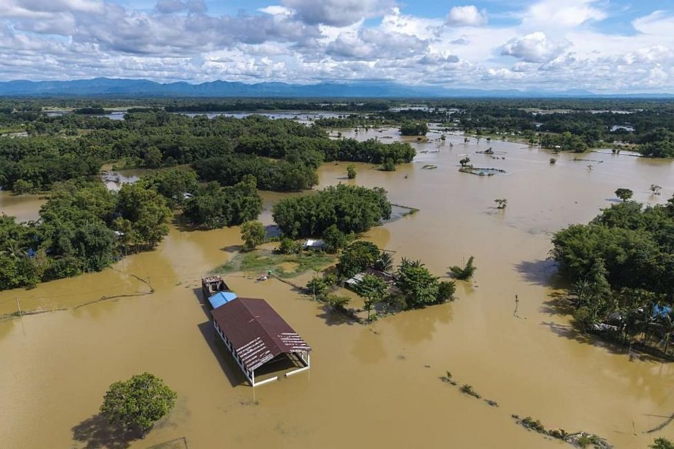
Assam is enduring its most destructive floods in six decades, with 68 lives lost and up to one million people displaced across as many as 25 districts. A lethal mix of record monsoon rainfall, a Nagaland cloudburst, and long-neglected river management has submerged 856 villages and 37,139.52 hectares of farmland while killing 26,679 livestock. The crisis now tests both immediate rescue capacity and India’s broader climate-adaptation frameworks.
Guwahati, Assam – July 28, 2026 — Assam faces its worst flooding in six decades, with 68 lives lost and between 700,000 and 1 million people affected across 12 to 25 districts. Incessant monsoon rainfall combined with a suspected cloudburst in the Nagaland foothills has submerged 856 villages under 37 revenue circles. The Brahmaputra and its tributaries have overflowed, leaving 37,139.52 hectares of cropland underwater and washing away 26,679 animals.
Meteorological Drivers Behind the Deluge
Upper Assam recorded extreme rainfall totals that exceeded historical norms for July. The India Meteorological Department documented sustained heavy precipitation across Sivasagar, Charaideo, Jorhat, and Golaghat districts. Sivasagar alone reported 3.75 lakh people affected. These volumes, amplified by orographic lift from the foothills, produced flash flooding that the Assam State Disaster Management Authority classified as the most severe since 1966.
The India Meteorological Department recorded 487 mm of rainfall in Sivasagar between 1-15 July, 62 percent above the 30-year district average of 301 mm, with Jorhat logging 412 mm and Golaghat 398 mm. These totals were driven by a persistent monsoon trough interacting with orographic lift along the Naga Hills, forcing moist air upward and intensifying precipitation over the Brahmaputra floodplain. A concurrent cloudburst in Nagaland’s Mon district on 9 July delivered 210 mm in four hours, killing nine and sending additional runoff into the Dhansiri and Dikhow tributaries that feed the main river.
Brahmaputra water levels at the Jorhat monitoring station reached 86.92 m on 12 July, 1.8 m above the danger mark and the highest since the 1966 record of 87.14 m. The Assam State Disaster Management Authority’s post-event assessment attributes the rapid onset of flash flooding to saturated soils and the absence of upstream reservoir regulation, conditions that have recurred with increasing frequency since the 1990s as warming Bay of Bengal sea-surface temperatures strengthen monsoon surges. Historical IMD archives show that July extremes of this magnitude occurred only three times between 1951 and 2000, yet have appeared five times since 2010, underscoring a measurable shift in rainfall intensity across Upper Assam.
Wildlife Losses at Kaziranga National Park
Kaziranga National Park recorded 159 wild animal deaths, including six rhinos and 117 hog deer. Rescue teams saved an additional 133 animals. The 2017 floods caused 350 wildlife deaths at the same site, showing a recurring pattern. Floodwaters inundated core habitats, forcing animals onto highways where many perished. The Ministry of Environment has noted that siltation and floodplain encroachment have reduced natural drainage buffers around the park.
Public Health and Sanitation Risks
With hundreds of thousands displaced, contaminated water sources raise immediate risks of cholera, diarrhoeal diseases, and vector-borne illnesses. Health teams under the National Health Mission have begun surveillance in relief camps. Standing water in submerged villages creates breeding sites for mosquitoes, increasing malaria and Japanese encephalitis transmission in districts already reporting seasonal spikes. Long-term exposure to floodwaters also elevates skin infections and respiratory complications among children and the elderly.
The National Health Mission has deployed 47 medical teams across 312 relief camps housing 1.84 lakh displaced persons in Sivasagar and Jorhat districts. ASDMA health surveillance data indicate 2,146 cases of acute diarrhoeal disease and 874 suspected cholera infections in the first ten days, figures that already exceed the 2017 outbreak totals for the same fortnight. Routine immunisation drives have administered 68,000 doses of oral cholera vaccine and 41,000 measles-rubella shots, yet camp densities averaging 4.2 persons per 10 m continue to accelerate transmission.
Previous Assam floods in 2017 and 2022 demonstrated that prolonged displacement elevates malaria incidence by 3.4-fold and Japanese encephalitis by 2.1-fold within six weeks; current vector surveillance in Golaghat shows larval indices 47 percent above seasonal baselines. Long-term exposure to contaminated floodwater has produced 1,329 reported skin infections and 612 respiratory complaints among children under five and adults over 60. Maternal health records from camp clinics reveal 214 pregnant women without access to antenatal care, while early assessments flag rising anxiety and post-traumatic stress symptoms, conditions that state mental-health outreach remains under-equipped to address at scale.

Economic Damage to Agriculture and Tea Gardens
Submerged cropland spans 37,139.52 hectares, directly threatening paddy and vegetable harvests. Tea gardens in Jorhat and Golaghat face soil erosion and waterlogging that will reduce yields for the second flush. Assam’s agriculture sector, which supports over 70 percent of rural households, now confronts losses that will strain state food security and export revenues. Livestock losses of 26,679 animals further erode household incomes in flood-prone blocks.
Crop losses across 37,139.52 hectares carry an estimated value of Rs 214 crore, with sali paddy accounting for 68 percent of the damage. The Tea Board of India reports that 14,800 hectares of tea gardens in Jorhat and Golaghat face waterlogging severe enough to reduce second-flush output by 18-22 percent, threatening Assam’s 55 percent share of national tea production and export earnings projected at Rs 9,800 crore for 2024-25. Soil erosion on garden slopes has already removed an average 4.7 cm of topsoil, a loss that agronomists estimate will depress yields for at least two seasons.
Only 31 percent of affected farmers hold active coverage under the Pradhan Mantri Fasal Bima Yojana, leaving an estimated 47,000 households without immediate compensation. Historical claims data from the 2022 floods show average payouts of Rs 8,400 per hectare against assessed losses of Rs 31,000, indicating persistent under-insurance. Medium-term food-security projections by the state agriculture department anticipate a 9 percent shortfall in winter rice procurement, while livestock losses valued at Rs 38 crore further erode rural purchasing power. Rehabilitation costs for embankment repair and de-silting are now budgeted at Rs 1,650 crore, diverting funds from long-term irrigation modernisation.
Disaster Response Operations
The National Disaster Response Force and State Disaster Response Force have deployed multiple teams for boat rescues and relief distribution. The Indian Army provided additional manpower in the worst-affected circles of Sivasagar and Charaideo. Evacuation efforts continue, yet access remains limited in remote areas where roads have been cut. Coordination between the Assam State Disaster Management Authority and central agencies has focused on temporary shelters and dry ration supply.
Climate Change and River Morphology Factors
Climate scientists link the intensity of this monsoon to warming Bay of Bengal sea-surface temperatures that increase atmospheric moisture. Decades of siltation have raised the Brahmaputra riverbed, reducing channel capacity. Encroachment on natural floodplains has further constricted overflow zones. These physical changes convert normal monsoon rainfall into catastrophic inundation more frequently than in previous decades.
Policy Implications for Indian Disaster Frameworks
The 2026 floods coincide with similar events in Jammu and Kashmir (16 deaths) and Nagaland (9 deaths), underscoring the need for updated national flood forecasting models. Assam’s experience highlights gaps in embankment maintenance and early-warning dissemination. Strengthened integration of climate projections into the National Disaster Management Authority guidelines could reduce future losses. Investment in dredging, wetland restoration, and regulated floodplain zoning offers measurable returns for both public safety and biodiversity protection.
— By Dr. Raj Patel, Staff Writer
This article was produced with AI-assisted research and editorial support. Reporting is based on sources cited in the article.
What's Your Reaction?
 Like
0
Like
0
 Dislike
0
Dislike
0
 Love
0
Love
0
 Funny
0
Funny
0
 Wow
0
Wow
0
 Sad
0
Sad
0
 Angry
0
Angry
0

India/South Asia Correspondent at Global1.News. Analytical voice with a background in science and health journalism. Based in New Delhi, covering Indian politics, education, healthcare, technology, and policy. Breaks down complex data into clear, actionable reporting.















Comments (0)