
Arnab Is Not a Cyclone Yet. By Wednesday It Is Forecast to Hit Andhra Pradesh at 140 kmph
A depression over the Bay of Bengal is forecast to become Cyclone Arnab and cross the Andhra Pradesh coast between Bapatla and Visakhapatnam on 28 October as a very severe cyclonic storm, with winds of 115 to 125 kmph gusting to 140. Red alerts cover 13 districts.

The depression over the eastcentral and adjoining southeast Bay of Bengal is not yet a cyclone, not yet named, and still 860 kilometres east-southeast of Visakhapatnam. But the India Meteorological Department's second bulletin of the season puts it on a straight line to the Andhra Pradesh coast as a very severe cyclonic storm by the morning of 28 October, with maximum sustained winds of 115 to 125 kilometres per hour gusting to 140. Andhra Pradesh has issued a red alert for 13 districts. Odisha has cancelled the leave of government employees in four districts and shut schools in five.
Arnab Is Not a Cyclone Yet. By Wednesday It Is Forecast to Hit Andhra Pradesh at 140 kmph
VISAKHAPATNAM, India — The system lay centred at 2330 hours IST on 24 October near Latitude 15.5 degrees North and Longitude 91.0 degrees East, according to IMD National Bulletin No. 2, signed by Dr. M. T. Bushair, Scientist D, Cyclone Warning. It moved southeastwards at 8 kmph over the previous six hours. Its maximum sustained surface wind was 40 to 50 kmph gusting to 60. That is a depression. The forecast that follows is not. IMD expects a deep depression by the night of 25 October, a cyclonic storm by the morning of 26 October, a severe cyclonic storm by the morning of 27 October, and a very severe cyclonic storm near the Andhra Pradesh coast by the morning of 28 October.
The Coordinates and the Clock
The distances in the bulletin are the story. At 2330 hours IST on 24 October the depression was 470 kilometres north-northwest of Sri Vijaya Puram in the Andaman Islands, 860 kilometres east-southeast of Visakhapatnam, 950 kilometres east-southeast of Kakinada, 1,060 kilometres east of Machilipatnam and 1,130 kilometres east of Bapatla. The Hindu, reporting from Vijayawada, worked from the bulletin issued at 9.30 p.m. on Saturday evening, which put the system about 510 kilometres off the Andaman coast, 820 kilometres off Visakhapatnam, 910 kilometres off Kakinada, 1,020 kilometres off Machilipatnam and 1,100 kilometres off Bapatla. The two sets differ by about 40 kilometres at Visakhapatnam because they are two readings taken two hours apart of a system drifting southeast. It is moving away from the coast before it turns. What is not in dispute is the clock. IMD's next bulletin is due at 0830 hours IST on 25 October. The sea is already building.
Why the Name Comes Later
The storm has no name because it is not yet a cyclone. Arnab is assigned when the system reaches cyclonic-storm status, which IMD forecasts for the morning of 26 October. Telegraph India reports that it will be the Bay's first cyclone of the year, and that the name, meaning ocean or sea, was given by Bangladesh. The Indian Express puts the same point plainly: India's east coast may soon see Arnab, the year's first cyclone. Until the system is upgraded the correct word is depression. Not Arnab. Not a cyclone. The distinction is not pedantry. It is the difference between a weather system and a named storm with a track, an intensity forecast and a landfall window.
The Forecast Track, Step by Step
IMD's intensity table lays out the next four days in twelve-hour steps. At 1130 hours IST on 25 October the system is forecast at 14.8 degrees North, 90.9 degrees East, with winds of 45 to 55 kmph gusting to 65, still a depression. By 2330 hours on 25 October it is forecast at 14.2 degrees North, 90.0 degrees East, with winds of 55 to 65 kmph gusting to 75, a deep depression. At 1130 hours on 26 October it is forecast at 14.3 degrees North, 88.2 degrees East, with winds of 70 to 80 kmph gusting to 90, a cyclonic storm. By 2330 hours on 27 October it is forecast at 16.0 degrees North, 83.3 degrees East, with winds of 100 to 110 kmph gusting to 120, a very severe cyclonic storm. At 1130 hours on 28 October it is forecast at 17.0 degrees North, 82.0 degrees East, with winds of 115 to 125 kmph gusting to 140. That is the landfall window: between Bapatla and Visakhapatnam, by forenoon.
Andhra Pradesh's Thirteen Districts
The Hindu reports a red alert for 13 districts of Andhra Pradesh for 27 and 28 October. Krishna and Bapatla districts are on alert for 27 October. Visakhapatnam, Alluri Sitharama Raju, Anakapalli, Kakinada, Dr. B.R. Ambedkar Konaseema, East Godavari, West Godavari, Eluru, NTR, Krishna, Guntur and Bapatla are on alert for 28 October. Isolated extremely heavy rainfall is expected in these districts. The state may receive light showers on 25 and 26 October, with cyclone-induced rainfall activity expected to increase from there. The Hindu quotes weather experts comparing the wind to Cyclone Montha, when Machilipatnam recorded 65 kmph: this time, the report says, wind speeds may go up to 130 kmph. The Hindu, quoting the weather office, describes the expected intensity as the second highest. The Hindu gives the associated wind range as 118 to 221 kmph. No evacuation figure has been published for coastal Andhra Pradesh.
Odisha's Zero-Casualty Doctrine
Odisha activated its disaster response machinery on Saturday 24 October. Chief Minister Mohan Charan Majhi reviewed preparedness and directed officials to prioritise public safety, evacuation and emergency response, stressing a zero-casualty objective. He said the cyclone could affect Odisha with heavy rainfall in southern and coastal districts and gusty winds of 70 to 90 kmph. Five districts are most likely affected, per the Chief Minister: Ganjam, Gajapati, Rayagada, Koraput and Malkangiri. Educational institutions in five districts will be closed on 28 and 29 October. Leave of all government employees is cancelled in Ganjam, Gajapati, Puri and Khurda. Disaster Management Minister Suresh Pujari said: "We have asked all 30 districts to be on alert. Collectors of 16 coastal and southern districts have been advised to take precautionary measures." Puja committees in Cuttack have been asked to remove decorative bamboo structures. NDRF, ODRAF and Fire and Emergency Services personnel are on standby. The storm has already moved the Presidency: President Droupadi Murmu's two-day Odisha visit from 28 October, which was to take her to Rairangpur and her home district of Mayurbhanj, has been rescheduled to 4 and 5 November.
What the Sea Will Do
IMD's sea-condition forecast is a ladder. Over the westcentral Bay of Bengal, conditions are rough to very rough from the evening of 25 October, high from the morning of 26 October, very high by the morning of 27 October, and "Phenomenal" by the morning of 28 October, lasting till the afternoon. Along and off the Andhra Pradesh and Yanam coasts, the sea is rough to very rough from the morning of 27 October, high to very high by the evening, and phenomenal by the morning of 28 October. Fishermen are warned not to venture into the westcentral and adjoining northwest and southwest Bay from 26 to 28 October, or along and off the Andhra Pradesh-Odisha coasts from 27 to 28 October. The bulletin asks for total suspension of offshore and onshore operations.
The Rain That Arrives First
The wind comes Wednesday. The rain comes Monday. IMD director general Mrutyunjay Mohapatra, quoted by New Indian Express, says rainfall along the east coast, particularly north Andhra Pradesh, Odisha and West Bengal, would begin on Monday, with heavy to very heavy rainfall from Tuesday. He is quoted saying "extremely heavy rainfall exceeding 30 cm could occur at isolated places in north Andhra Pradesh and Odisha on Wednesday and Thursday." The bulletin's rainfall warnings run wider than the two headline states: Telangana's eastern parts on 28 October, and, from 28 to 30 October, Chhattisgarh, Jharkhand, Bihar, Gangetic West Bengal, Sikkim, Vidarbha, East Madhya Pradesh and East Uttar Pradesh. The Andaman Islands get heavy rain at isolated places from 25 to 27 October.
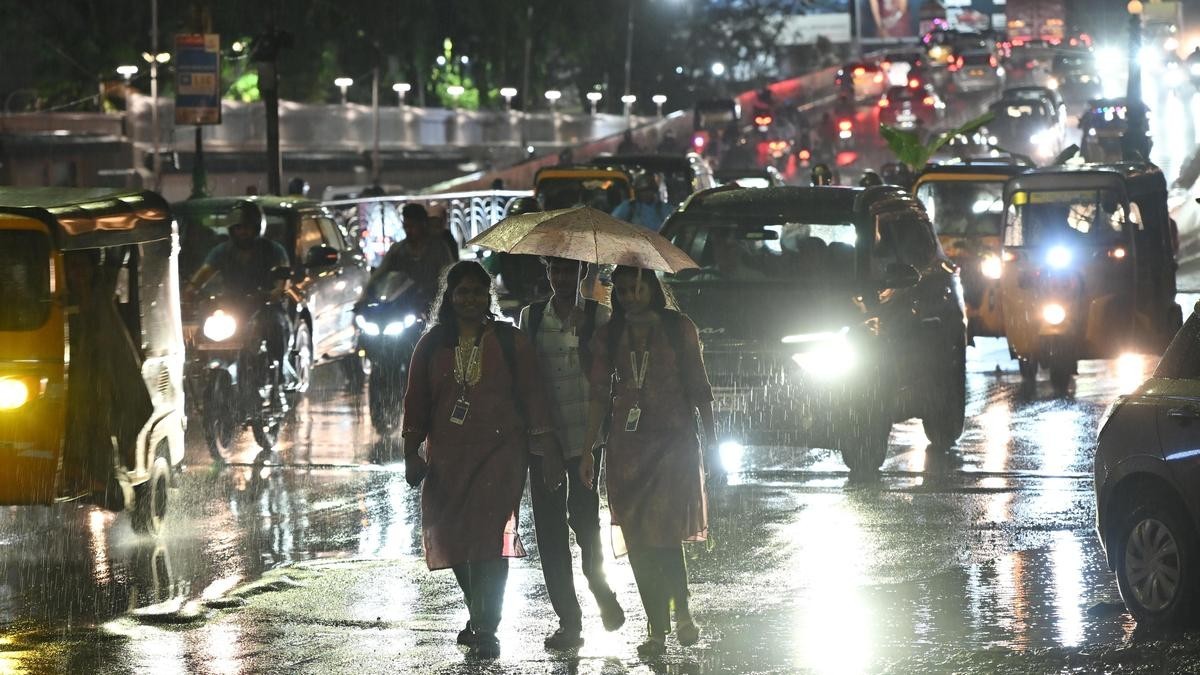
None of that is the rain that has already fallen. A second low-pressure area over the southeast Arabian Sea and adjoining Lakshadweep, which has nothing to do with the Bay system, has been soaking Tamil Nadu since last week. IMD recorded extremely heavy rainfall of 21 centimetres or more over Tamil Nadu in the 24 hours to 0830 hours IST on 24 October, and the Regional Meteorological Centre put heavy to very heavy rain across the delta, western and Nilgiris districts on Sunday, with a red alert for Theni, Dindigul and Madurai. Burliyar in the Nilgiris took 25 centimetres, the highest in the state, and on Friday night a landslide on the Coonoor-Mettupalayam ghat road buried a state transport bus and killed its driver. The conductor was pulled out alive after more than eight hours. The outlets reporting the death give the driver's age as 51 and as 55.

Last Year's Bill
Cyclone Montha made landfall on the Andhra Pradesh coast on the night of Tuesday 28 October 2025. Reuters reported from Hyderabad on 30 October 2025 that damage was estimated at nearly 53 billion rupees, about 603 million dollars, as farms, roads and buildings were flooded. An early assessment indicated the farm sector suffered the highest losses at 8.68 billion rupees, and the storm killed 120 animals. "No human casualties were reported from the cyclone," Chief Minister Chandrababu Naidu said, although local media reported that two women had died. Heavy rain also lashed neighbouring Telangana. Cyclones frequently hit India's east coast between April and December. A super cyclone that killed nearly 10,000 people when it struck Odisha in 1999 remains one of the country's deadliest natural disasters. That is the benchmark against which Odisha's zero-casualty language is measured.
What Is Not Known Yet
There is no confirmed death toll, injury count, evacuation figure or damage estimate for this system. None exists. The system is still officially a depression as of bulletin no. 2 at 0200 hours IST on 25 October. It has not been named and it is not yet a cyclonic storm. IMD's landfall band is "between Bapatla and Visakhapatnam," and that is as specific as the official forecast gets. Forecasters note that an anti-cyclone and a ridge to the north could influence the track and the landfall location. Some models put the crossing nearer Kakinada. The reporting does not agree on the exact track, and no one should pretend otherwise. Odisha has not ordered evacuations. It has cancelled leave, closed schools and put teams on standby. IMD's bulletin says "mobilise evacuation," which is advisory language. No source in the record attributes this storm to climate change.
What to Watch Between Now and Wednesday
Three things. First, the 0830 hours IST bulletin on 25 October, which will show whether the system has begun its forecast recurve west-northwestwards and whether the intensity table holds. Second, the morning of 26 October, when IMD expects cyclonic-storm status and the name Arnab. Third, the morning of 27 October, when the severe-cyclonic-storm forecast lands and the track either tightens toward Bapatla or drifts toward Kakinada. Skymet, the private forecaster, says the system is over open ocean in favourable conditions and puts the potential for cyclogenesis in the next 72 hours as high. The Joint Typhoon Warning Center cites low vertical wind shear of 5 to 10 knots, sea surface temperatures of 29 to 30 degrees Celsius and moderate equatorward outflow aloft. Models agree on gradual development. They do not agree on where it lands.
By Jessica Ali, Staff Writer
This article was produced with AI-assisted research and editorial support. Sources: India Meteorological Department, The Hindu, New Indian Express, Telegraph India, The Indian Express and Reuters. Photographs: Kommuri Srinivas / The Hindu (cover), B. Velankanni Raj / The Hindu (Chennai rain), S Senbagapandiyan / The New Indian Express (Nilgiris).
What's Your Reaction?
 Like
0
 Dislike
0
 Love
0
 Funny
0
 Wow
0
 Sad
0
 Angry
0

Editor-in-Chief at Global1.News. Atlanta-based journalist who cuts through the BS and tells it like it is. Lead anchor, host, and the voice you hear when the spin stops and the truth starts.















Comments (0)